31st Annual Backcountry Benefit - September 12th - Tickets Available Here!

Forecast for the Logan Area Mountains

Toby Weed
Issued by Toby Weed on
Friday morning, December 8, 2023
Heavy snow and drifting from blustery west winds will cause increasing avalanche danger today. Elevated avalanche conditions already exist on many upper-elevation slopes this morning. The danger will be CONSIDERABLE at upper and mid-elevations on drifted slopes steeper than 30 degrees. People are likely to trigger avalanches of wind-drifted snow failing on a persistent weak layer up to 3 feet deep and some could be triggered remotely or from a distance. Less danger exists in sheltered terrain and at low elevations.

Careful snowpack evaluation, cautious route-finding, and conservative decision-making are essential for backcountry travel in the higher terrain today.
Low
Moderate
Considerable
High
Extreme
Learn how to read the forecast here
Special Announcements
The 5th Annual Avalanche Awareness Week is December 3-10. The week's goal is to save lives through activities that promote avalanche awareness, education, and safety. We have a variety of events around the state. Find an event near you.
Join the Utah Avalanche Center and Utah State University for a FREE Avalanche Transceiver Training on Saturday, December 9, from 10 AM - 12 PM at the USU Aggie Legacy Fields in Logan. Register here.
Weather and Snow
Around 6 inches accumulated in the Central Bear River Range yesterday. I'm reading 4" new snow from overnight at the new Card Canyon weather station. About 8" is visible this morning on the lit interval stake on the Beav's webcam. The Tony Grove Snotel at 8400' reports 1.3" SWE from yesterday and overnight, and it's showing a total snow depth of 51 inches. It's 13 F this morning on Paris Peak, and the wind is blowing from the west-northwest at 18 mph, gusting to 33 mph at 5:00 this morning.

Today will be rather stormy in the mountains, with heavy snow and significant drifting expected. 8500' temperatures are expected to drop to around 14 F today, 8 to 12 inches of new snow is expected to accumulate on high slopes, and west-northwest winds will blow around 25 mph with 40 mph gusts. Wind chills will be as low as -10 F tonight, northwest winds will moderate a little, and snowfall should taper off. Expect crisp, sunny weather in the mountains tomorrow, with high temperatures only around 18 F above 8000'.
Recent Avalanches
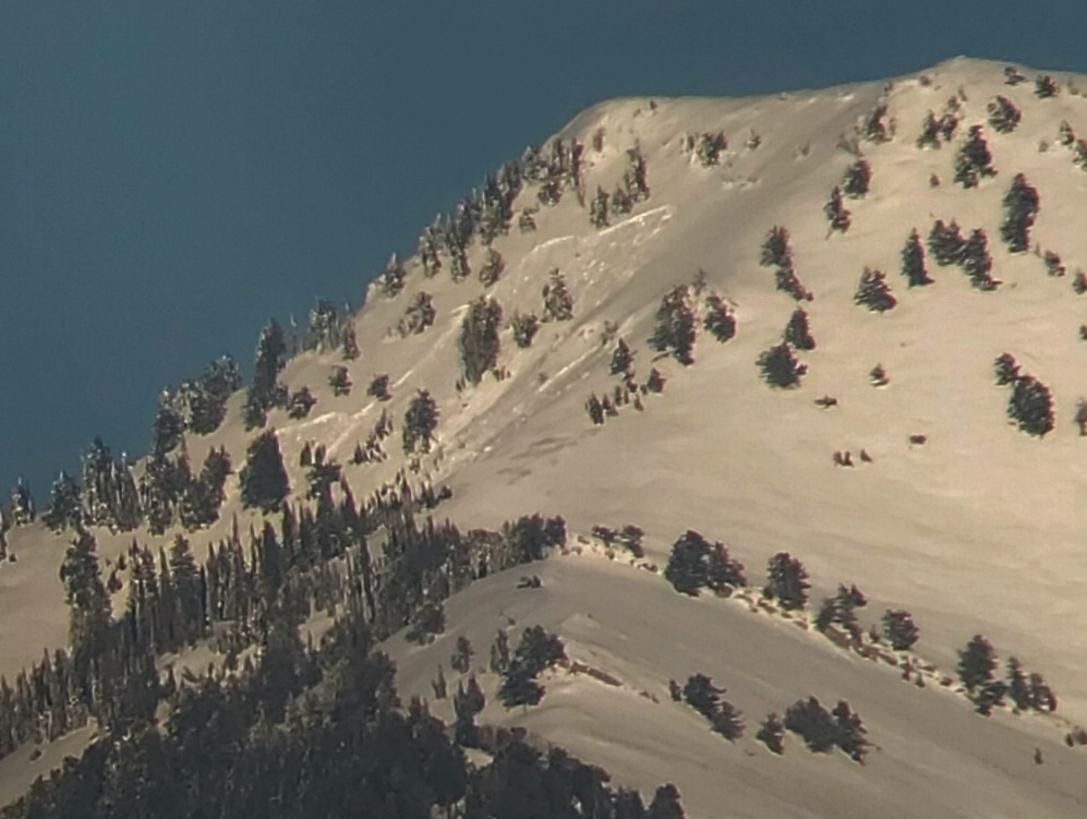
We observed numerous recent natural avalanches in the Central Bear River Range that occurred late on Sunday and overnight Monday. Several more large avalanches were observed from a distance Wednesday in Wood Camp and the Mt. Naomi and Wellsville Mountain Wildernesses. Some were 2 to 3 feet deep and several hundred feet wide.
You can visit our avalanche page to check out the recently reported avalanche activity from the Bear River Mountains and the Wasatch Range.

A large natural avalanche was observed in the Mt. Naomi Wilderness above Richmond. (Eric and Amy Flygare)
Ad
Avalanche Problem #1
Persistent Weak Layer
Type
Location
Likelihood
Size
Description
The November snow in upper elevation avalanche starting zones before the weekend storm is extremely weak and sugary due to its shallowness and sustained cold temperatures. Heavy snow and drifting from last weekend’s storm overloaded this weak faceted snow (now a persistent weak layer), and several large avalanches up to 3 feet deep and several hundred feet wide occurred at the very beginning of the week. We've noted increasing stability in recent days, and avalanches are generally unlikely on slopes bare of snow or that had very shallow snow cover before last weekend's storm.
Unfortunately, we observed a thin, newly developed layer of weak sugary snow on the snow surface in many areas Wednesday. It could easily be the next persistent weak layer after it was buried and preserved by yesterday's snow.
  • Avalanches failing on a persistent weak layer could be triggered remotely, from a distance, or below.
  • Cracking and collapsing (or whumpfs) are definite signs of instability.
Avalanche Problem #2
Wind Drifted Snow
Type
Location
Likelihood
Size
Description
Blustery winds from the west and northwest today will drift plenty of fresh snow into avalanche-starting zones. In some cases, fresh drifts will overload slopes with weak sugary surface snow.
Avoid stiffer, drifted snow on the lee side of major ridges and in and around terrain features like gullies, sub-ridges, scoops, mid-slope rollovers, and rock outcroppings or cliff bands.
Additional Information
We were able to check out a recent natural avalanche in Miller Bowl above Tony Grove Lake Wednesday and this is what we found,

This fall, we installed two new weather stations in the Logan Zone. They are both up and running, producing real-time data available to the public, and they will help us forecast mountain weather and local avalanche danger more accurately.
  • The Paris Peak Weather Station (available HERE) was installed in the northern Bear River Range near the summit of Paris Peak at around 9500 feet in elevation, northwest of Bear Lake. It measures mountain-top winds in a vast area without similar data.
  • We installed the Card Canyon Weather Station (available HERE) near Red Pine Ridge at about 8750 feet in elevation north of Logan Peak in upper Card Canyon. In addition to other weather details, this station will measure the total snow depth and its changes throughout the winter.
General Announcements
Taking time to pull out, check your companion rescue gear, and practice with your transceiver is essential. watch a short video here
The Tony Grove Road is not maintained for winter driving, and you will encounter very deep snow conditions if you venture up there. You will get stuck if you try it.
Our 20th annual Pray For Snow fundraiser party was a huge success. Thanks for coming and showing your support!
This forecast is from the U.S.D.A. Forest Service, which is solely responsible for its content. This forecast describes general avalanche conditions, and local variations always occur.
We will update this forecast tomorrow morning.