31st Annual Backcountry Benefit - September 12th - Tickets Available Here!

Forecast for the Logan Area Mountains

Toby Weed
Issued by Toby Weed on
Saturday morning, December 9, 2023
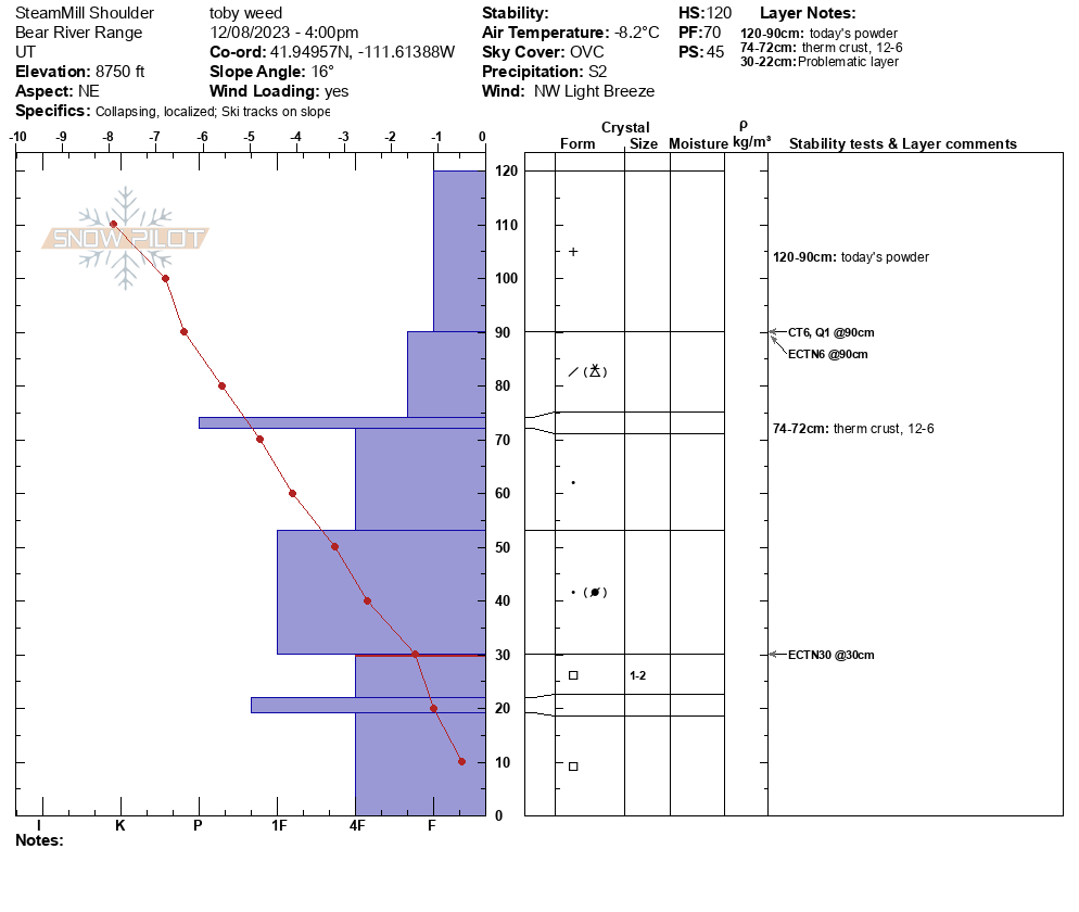
People will find excellent deep powder riding conditions in the backcountry. Elevated avalanche conditions are found on many slopes steeper than about 30 degrees, and the danger is MODERATE. People could trigger slab avalanches of wind-drifted snow in exposed terrain and loose or soft slab avalanches of storm snow on more sheltered slopes with up to two feet of fresh powder.
Dangerous avalanches failing on a persistent weak layer are becoming less likely but are still possible in outlying terrain and upper-elevation areas with shallow snow cover.
Less dangerous conditions exist in sheltered and low-elevation terrain.

Evaluate the snow and terrain carefully.
Low
Moderate
Considerable
High
Extreme
Learn how to read the forecast here
Special Announcements
The 5th Annual Avalanche Awareness Week is December 3-10. The week's goal is to save lives through activities that promote avalanche awareness, education, and safety. We have a variety of events around the state. Find an event near you.
Join the Utah Avalanche Center and Utah State University for a FREE Avalanche Transceiver Training on Saturday, December 9, from 10 AM - 12 PM at the USU Aggie Legacy Fields in Logan. Register here.
Weather and Snow
About two feet of nice powder accumulated on many slopes in the Central Bear River Range. The Tony Grove Snotel at 8400' reports 23" of settled new snow with 2.6" SWE, with a total snow depth of 64 inches. It's 6 F this morning on Paris Peak, and the wind is blowing lightly from the north.

Expect crisp, mostly sunny weather in the mountains today, with 8500' high temperatures only around 18 F and wind chills as low as -9 F.
Snow is likely in the mountains tomorrow, but accumulations will be light.
Cloudy conditions and periods of light snow with little accumulation are expected for the beginning of the week. Cold temperatures and both partly cloudy and sunny conditions are expected later in the week. No significant storms are in the near-term forecast.

Recent Avalanches
On Friday, riders triggered a couple of small, very soft slab avalanches of storm snow in steep terrain near Tony Grove Lake.
You can visit our avalanche page to check out the recently reported avalanche activity from the Bear River Mountains and the Wasatch Range.
Ad
Avalanche Problem #1
Wind Drifted Snow
Type
Location
Likelihood
Size
Description
In exposed terrain, blustery winds from the west and northwest yesterday drifted plenty of fresh powder into avalanche-starting zones. In some cases, fresh drifts overloaded slopes with weak sugary surface snow.
  • Avoid stiffer, drifted snow on the lee side of major ridges and in and around terrain features like gullies, sub-ridges, scoops, mid-slope rollovers, and rock outcroppings or cliff bands.
  • Drifted snow is stiffer than fresh powder, but some wind slabs formed during the storm could be covered and hidden by a few inches of snow that fell overnight in calmer conditions.
Avalanche Problem #2
New Snow
Type
Location
Likelihood
Size
Description
Loose snow avalanches and soft slabs of storm snow are possible for people to trigger on slopes steeper than 30 degrees, especially in areas that picked up significant new snow yesterday (up to around 2' in some areas). Deep new snow accumulated in some lower-elevation areas yesterday. I found around 18" in the Franklin Basin parking lot.
The biggest hazard with small storm snow avalanches is the potential of being pushed off ledges or into terrain traps or trees below you.
Avalanche Problem #3
Persistent Weak Layer
Type
Location
Likelihood
Size
Description
Dangerous avalanches failing on a buried, persistent weak layer are becoming more unlikely as the shallow, sugary snow from November is buried and pushed into terrain anchors by a deep layer of heavy and hardening snow.
  • Avalanches failing on a persistent weak layer could be triggered remotely, from a distance, or below.
  • Cracking and collapsing (or whumpfs) are definite signs of instability.

Additional Information
We were able to check out a recent natural avalanche in Miller Bowl above Tony Grove Lake Wednesday and this is what we found,

This fall, we installed two new weather stations in the Logan Zone. They are both up and running, producing real-time data available to the public, and they will help us forecast mountain weather and local avalanche danger more accurately.
  • The Paris Peak Weather Station (available HERE) was installed in the northern Bear River Range near the summit of Paris Peak at around 9500 feet in elevation, northwest of Bear Lake. It measures mountain-top winds in a vast area without similar data.
  • We installed the Card Canyon Weather Station (available HERE) near Red Pine Ridge at about 8750 feet in elevation north of Logan Peak in upper Card Canyon. In addition to other weather details, this station will measure the total snow depth and its changes throughout the winter.
General Announcements
Taking time to check your companion rescue gear and practice with your transceiver is essential. watch a short video here
The Tony Grove Road is not maintained for winter driving, and you will encounter very deep snow conditions if you venture up there. You will get stuck if you try it.
Our 20th annual Pray For Snow fundraiser party was a huge success. Thanks for coming and showing your support!
This forecast is from the U.S.D.A. Forest Service, which is solely responsible for its content. This forecast describes general avalanche conditions, and local variations always occur.
We will update this forecast tomorrow morning.