Issued by Toby Weed on Saturday morning, December 7, 2019
South winds picked up overnight and have created potential for human triggered avalanches involving wind drifted snow. Heightened avalanche conditions exist, and there is MODERATE danger on drifted slopes and in steep shady terrain at upper elevations. You could trigger a dangerous avalanche failing on a persistent weak layer of loose sugary snow near the ground. You can find safer conditions and LOW danger at lower elevations, in sheltered terrain, and on sunny slopes that were bare before the Thanksgiving storm.
FREE Beacon training clinic at Beaver Mountain today, 10am till noon. The Utah Avalanche Center and Grassroots Powdersurfing will be there to introduce you to avalanche beacons or refresh your skills. Meet in front of the lodge. Powdersurf demo boards available too! Bring the family!
Weather and Snow
It's 31°F at the 8400' Tony Grove Snotel this morning, and I'm reading 30 inches of total snow containing 7" SWE, which is 97% of normal for the date. It's 23°F at the 9700' CSI Logan Peak weather station, and south-southwest winds are blowing about 34 mph, with a 53 mph gust earlier this morning. Drifting snow created elevated potential for human triggered avalanches, and heightened avalanche conditions persist on upper elevation slopes facing northeast, north, and northwest, where a person might trigger a dangerous avalanche failing on a buried persistent weak layer near the ground.
Today will be partly sunny and breezy, with 8500' high temperatures around 33°F and 22 to 25 mph southwest winds. There is a chance of some snow, but little accumulation is expected. Snow showers will be likely in the mountains tonight, with 1 to 3 inches possible. Temperatures will top out around 31°F, and 17 to 21 mph southwest winds are expected. Snow will continue tomorrow, with another 1 to 3 inches possible. Expect high temperatures around 31°F, dropping to around 26°F in the morning, and it will be breezy, with 18 to 25 mph west wind.
Recent Avalanches
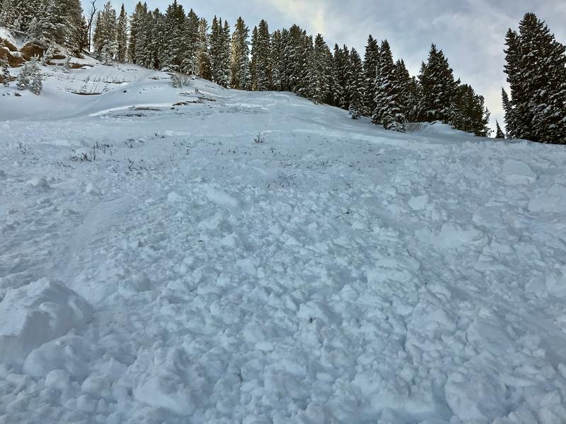
Tuesday, a solo skier unintentionally triggered a good sized avalanche failing on the sugary persistent weak layer near the ground in the west half of Miller Bowl south of Tony Grove Lake. The avalanche on a north facing slope at around 8700' was around 2' deep and at least 150' wide.
A natural avalanche involving wind drifted snow was spotted by observers Sunday (12-1-19) on the west side of Logan Peak in upper Logan Dry Canyon. The fresh avalanche was about 1 foot deep and 300 feet wide..
No other avalanches were reported locally, but folks continue to trigger audible collapses or whumpfs in shady upper and mid elevation terrain.
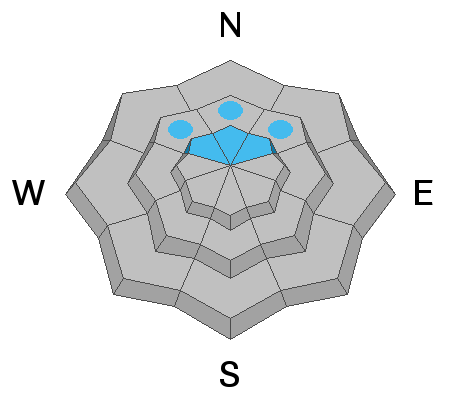
Avalanche Problem #1
Persistent Weak Layer
Type
Location
Likelihood
Size
Description
Most sunny slopes were bare and many others patchy or crusty after the prolonged November dry spell. But on slopes above about 8000' facing northwest, north, and northeast, the old October snow has grown sugary and very weak. Dangerous and destructive avalanches failing near the ground are possible, and the danger on many of these slopes will persist for a while. The snow is gradually becoming more stable, but avalanches on some slopes could still be triggered remotely, from a distance, or below! Tuesday's close call in Miller Bowl near Tony Grove Lake confirms that dangerous human triggered avalanches remain possible in some areas.
Cracking and collapsing are red flags indicating unstable snow conditions.
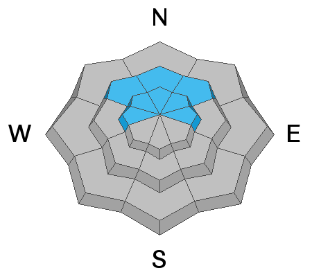
Avalanche Problem #2
Wind Drifted Snow
Type
Location
Likelihood
Size
Description
South winds increased overnight and are sustaining average speeds in the 30's with gusts in the 50s on Logan Peak. The few inches of fresh snow from earlier in the week was easily picked up and drifted into lee slope deposition areas. Stiff drifts may be sensitive to human triggering this weekend, so as usual, avoid steep slopes with recently drifted snow.
Even small avalanches can be very dangerous in shallow snow conditions, because you could be dragged into rocks or stumps.
Additional Information
Thanks to the generous support of our Utah ski resorts and Ski Utah, we have discount lift tickets available. All proceeds from these go towards paying for avalanche forecasting and education! Get your tickets HERE.
Need a Christmas present for your favorite backcountry partner? Get one of these cool t-shirts to support the UAC and other avalanche centers across the U.S. HERE
General Announcements
The Tony Grove Road is not maintained for wheeled vehicles in the winter, and it is snowpacked, narrow, and icy in places. You could easily get stuck in deep snow, and it doesn't look like anyone was able to drive very far up recently. Hikers, cross country skiers, snow bikers, dogs, sleds, and 4x4s share the road this time of year, so be nice and keep your speed down around others.
It's key to head into the early avalanche season with the proper mindset. In this podcast, we talk with UAC program director Bo Torrey. Bo talks about particular risks unique to the early season, tips and tricks for knocking the rust off your early season rescue skills, and charts out the path forward with avalanche education. HERE