Forecast for the Logan Area Mountains

Toby Weed
Issued by Toby Weed for
Sunday, December 30, 2018
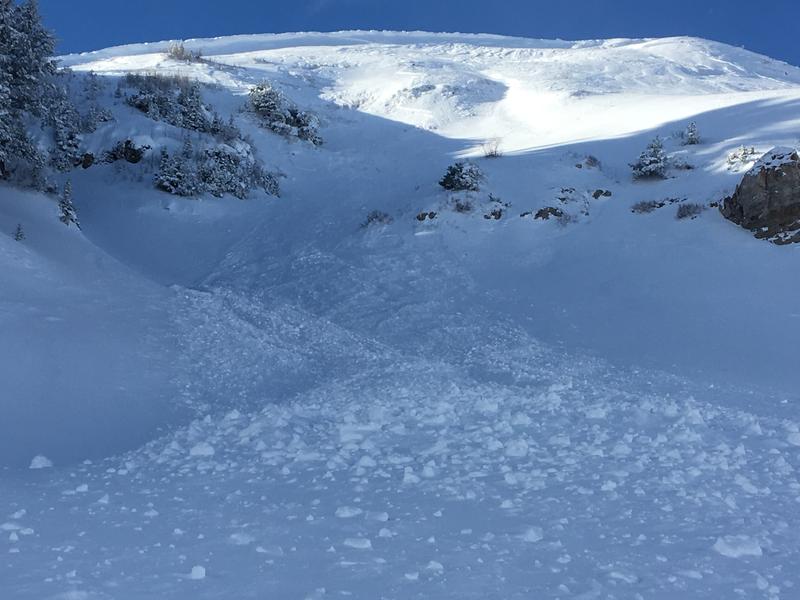
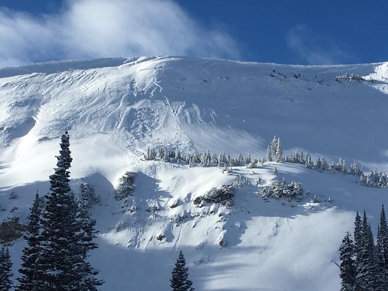
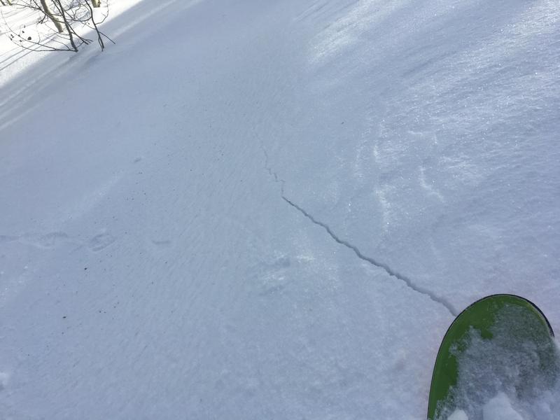
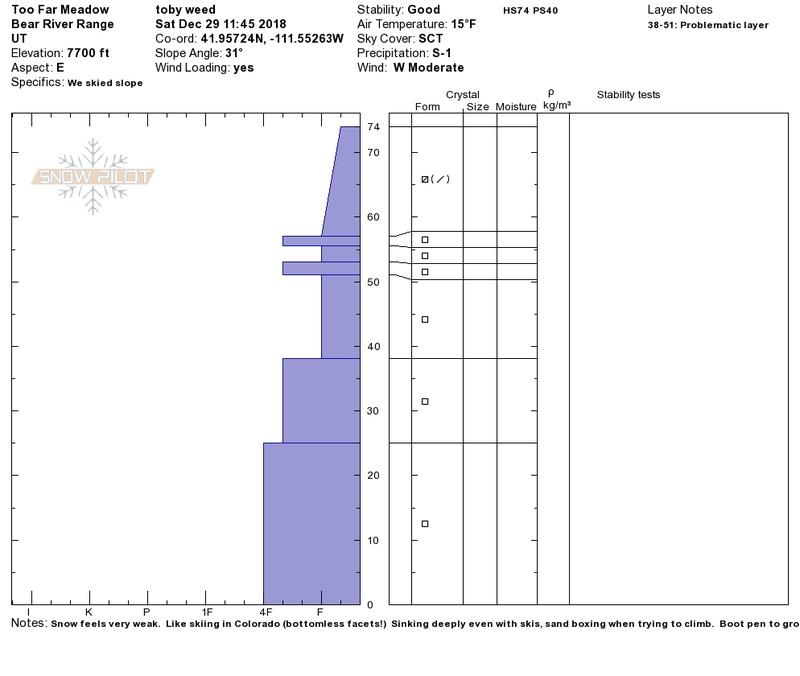
CONSIDERABLE: A cold and windy storm will cause rising avalanche danger in the backcountry today. Dangerous conditions will develop at upper elevations as storm snow rapidly accumulates and is drifted onto steep lee slopes. Human triggered avalanches will become likely and naturals possible on some slopes by mid afternoon. We'll also probably find heightened avalanche conditions on exposed mid and lower elevation slopes due to wind drifted snow.
Use extra caution in the backcountry today. Evaluate snow and terrain carefully, make conservative choices, and avoid steep slopes with wind drifted snow.
Low
Moderate
Considerable
High
Extreme
Learn how to read the forecast here
Weather and Snow
The National Weather Service in Pocatello has issued a Winter Storm Warning for the mountains of Southeast Idaho including the Bear River Range, and the NWS in Salt Lake City issued a Winter Weather Advisory for the mountains of Northern Utah.
The Tony Grove Snotel at 8400' reports 2 inches of light new snow from yesterday. It's 19º F this morning and there's 38"of total snow containing 83% of average SWE. It's 15º F at the 9700' CSI Logan Peak weather station, and west-southwest winds are currently averaging in excess of 30 mph, with gusts close to 60 mph!
A storm system will impact the area today into Monday, bringing the coldest temperatures of the season thus far to end 2018. Expect accumulating snow and fairly strong wind in the mountains today. 5 to 9 inches are forecast, with 25 to 30 mph west-southwest wind and dropping temperatures during the day (from about 22º F to around 12º F). Snowfall will continue into tonight, with 2 to 4 additional inches possible, low temperatures near 0º F, 20 to 25 mph northwest wind, and wind chills around -17º F. It'll be partly sunny tomorrow with high temperatures around 11º F, 7 to 13 mph northeast wind, and wind chills around -17º F. Looks like a high pressure system will take hold of the weather pattern for the upcoming work week, with very cold temperatures, sun in the mountains, and haze and smog building up in the valleys. There is hope of a warmer and moist storm next weekend.
Recent Avalanches
Noticed some natural avalanche activity due to wind drifted snow in upper Providence Canyon, likely from overnight 12/27/18.
Ad
Avalanche Problem #1
Wind Drifted Snow
Type
Location
Likelihood
Size
Description
Dangerous avalanche conditions will develop on upper elevation slopes as storm snow accumulates and is drifted onto steep slopes. You'll also find heightened conditions today on many mid and some lower elevation slopes, and you could trigger avalanches consisting of wind drifted snow.
  • Watch for and avoid drifted snow on the lee sides of major ridges and in and around terrain features like cliff bands, scoops, gullies, stringers, and sub-ridges.
  • Avoid steep slopes that have a smooth, rounded appearance, or that sound hollow like a drum.
  • Hard wind slabs have a nasty tendency to let you get well out on them before releasing.
  • Cracking in the snow is a red flag indicating potential instability.
Avalanche Problem #2
Persistent Weak Layer
Type
Location
Likelihood
Size
Description
Although unlikely, dangerous human triggered hard slab avalanches failing on a persistent weak layer near the ground called depth hoar remain possible on isolated upper elevation slopes. Avoid very steep slopes with poor snow structure, including shallow, shady, or rocky terrain at upper elevations.
The shallow snow on the ground in many areas has become loose, sugary, and faceted in the past couple weeks. I've found particularly weak snow at mid and lower elevations in the backcountry, anywhere where the total snow is fairly shallow. Lacking a slab of stronger snow on top for now, the sugary snow is currently stable despite it's weakness.
Sugary, faceted snow plagues the entire shallow snowpack in many backcountry areas. This from 12/29/18, on a east facing slope at 7700' from the Backside on the east side of Beaver Mountain in Beaver Canyon.
Additional Information
I will update this advisory tomorrow morning.
General Announcements
The new UAC IOS mobile app is now available on the app store. Check out the new "My Weather" feature. HERE
Check out the new free online avalanche course series developed by the Utah Avalanche Center. This is a great way to refresh your skills or prepare you for a Backcountry 101 or Level 1 class. HERE
Now is a great time to practice companion rescue techniques with your backcountry partners. Here is our practice video.
If you would like to get the daily advisory by email you subscribe HERE.
Support the UAC through your daily shopping. When you shop at Smith's, or online at REI, Backcountry.com, Patagonia, NRS, Amazon, eBay by clicking on these links, they donate a portion of your purchase to the UAC. If you sell on eBay, you can have your See our Affiliate Page for more details on how you can support the UAC when you shop
Remember your information can save lives. If you see anything we should know about, please help us out by submitting snow and avalanche observations. HERE You can call us at 801-524-5304, email by clicking HERE, or include #utavy in your Instagram.
This advisory is from the U.S.D.A. Forest Service, which is solely responsible for its content. This advisory describes general avalanche conditions and local variations always occur.