Get Your Ticket to the 32nd Annual Backcountry Benefit on September 11th! Support Forecasting, Awareness, and Education
Ad

Forecast for the Logan Area Mountains

Toby Weed
Issued by Toby Weed on
Wednesday morning, December 23, 2020
Dangerous avalanche conditions and CONSIDERABLE danger exist on drifted upper and mid elevation slopes. People are likely to trigger avalanches of wind drifted snow, 1 to 2 feet deep, failing on a sugary persistent weak layer. Avalanches are possible at all elevations, but you can find safer conditions in lower angled and sheltered terrain, and at lower elevations where only a couple inches of new snow accumulated.
  • Cracking and collapsing indicate unstable snow.
  • Avalanches could be triggered remotely or from a distance.
  • Stay off and out from under drifted slopes steeper than about 30 degrees.
Low
Moderate
Considerable
High
Extreme
Learn how to read the forecast here
Special Announcements
Thanks to the generous support of our local resorts, Ski Utah, and Backcountry, discount lift tickets are now available. Support the UAC while you ski at the resorts this season. Tickets are available here.
Weather and Snow
Looks like 7 or 8 inches of fairly light new snow fell yesterday and overnight on upper elevation slopes, which will refresh shallow powder conditions. Overall snow coverage is still very shallow in the Logan Zone, and the snow that was on the ground in November and early December is loose and sugary. In many places you still sink all the way to the ground when you hop off your sled. Trail breaking is difficult on skis because you sink deeply into the sugary snow, and scary on a sled because you expect to hit rocks and down trees at any moment. Not many people are out riding, especially off trail and there are already a few tales of broken A-arms....
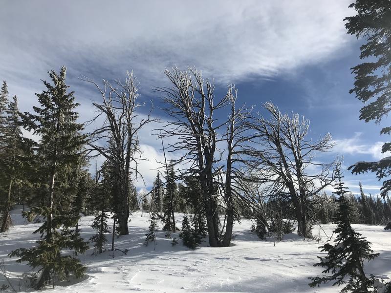
Solstice light and rime ice in the trees at upper elevations in Steep Hollow (12-21-2020...)

Expect sunny and cold conditions in the mountains today, with a chilly northwest breeze, high temperatures in the teens, and wind chill values as low as -10°F. A strong high pressure system will build over Utah in the next couple days, through Christmas. The next chance for snow looks to be over the weekend, as a storm (with some potential) should impact northern Utah. Dangerous avalanche conditions persist on steep drifted slopes at upper and mid elevations, and human triggered avalanches are likely.
Recent Avalanches
Heavy snow accumulated and was drifted onto steep mountain slopes with last Thursday's storm, overloading widespread sugary preexisting weak snow from November. Many natural and remote triggered avalanches were observed Friday in the Logan Zone. The 1' deep soft slab avalanches were fairly forgiving and nobody got caught..

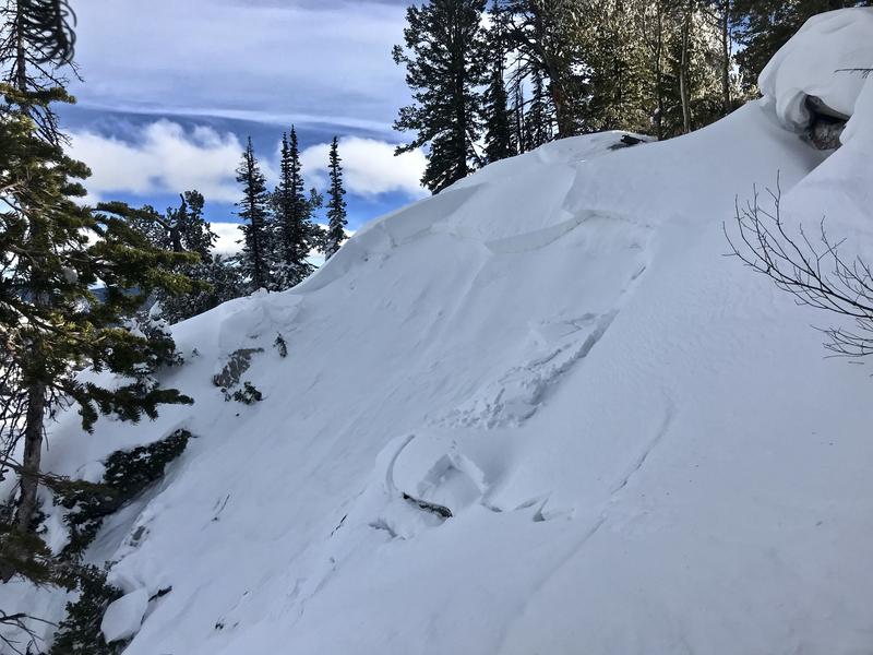
I ran across a fresh natural wind slab avalanche on Monday in Hell's Kitchen at around 9000' in elevation on an east facing slope. It was about 18" deep and about 40' wide, running around 400 vertical feet down into the bowl below
The natural avalanche consisted of recently drifted snow, and a small cornice fall likely triggered it.
Ad
Avalanche Problem #1
Persistent Weak Layer
Type
Location
Likelihood
Size
Description
Many slopes in the region are plagued by layers of weak faceted snow formed during the prolonged November dry spell. Avalanches failing on a persistent weak layer can be very sensitive, and they might be triggered remotely, from a distance, or worse from below!
A thick layer of very weak, sugary, or faceted snow will likely be a problematic persistent weak layer on many slopes, as future snow overloads it.
Avalanche Problem #2
Wind Drifted Snow
Type
Location
Likelihood
Size
Description
Fairly strong west and northwest winds yesterday and overnight drifted the fresh new snow into lee slope starting zones and around terrain features like gullies, cliff bands, and sub ridges. The new snow obscures hard drifts that formed over the weekend from southwest winds. Harder drifts or wind slabs are usually not as sensitive as soft ones, and they may allow people to get out on them and into avalanche paths before releasing.
  • People are likely to trigger dangerous avalanches of wind drifted snow, 1 to 2 feet deep, on steep upper and mid elevation slopes where drifts formed on weak, sugary, or faceted snow.
  • Even a small avalanche could be very dangerous due to shallow early season snow conditions.
Additional Information
Everybody should make time to examine and practice with your avalanche rescue equipment, and convince your backcountry partners to practice with you. Watch our companion rescue video HERE
My tip for avoiding avalanches in the backcountry is to keep your slope angles low. Avoid and stay out from under slopes steeper than about 30 degrees. Get a tool to measure slope angle and practice with it in the backcountry. Watch the video HERE.
Paige shows what we are talking about when we mention faceted snow in our forecasts. Watch the video HERE
General Announcements
Visit this website with information about Responsible Winter Recreation by the Utah Office of Outdoor Recreation.
We've kicked off Season 4 of the UAC podcast with a Conversation with American Avalanche Institute owner Sarah Carpenter. You can stream it HERE or wherever you get your favorite podcasts.
The Tony Grove Road is not maintained for wheeled vehicles in the winter.
EMAIL ADVISORY. If you would like to get the daily advisory by email you subscribe HERE.
Remember your information can save lives. If you see anything we should know about, please help us out by submitting snow and avalanche observations....HERE. You can also call us at 801-524-5304, email by clicking HERE, or include #utavy in your tweet or Instagram.
I will update this forecast by around 7:30 tomorrow morning.
This forecast is from the USDA Forest Service, which is solely responsible for its content. The forecast describes general avalanche conditions and local variations always occur.