Get Your Ticket to the 32nd Annual Backcountry Benefit on September 11th! Support Forecasting, Awareness, and Education
Ad

Forecast: Logan Area Mountains

Forecast for the Logan Area Mountains

Toby Weed
Issued by Toby Weed on
Tuesday morning, December 17, 2019
Areas with CONSIDERABLE danger exist on upper elevation slopes facing northwest, north, and northeast, and large and very dangerous human triggered avalanches failing on a persistent weak layer near the ground remain possible. Despite diminished winds in the mountains, avalanches of stiffer wind drifted snow are possible. You can find safer conditions and LOW danger on slopes less steep than about 30 degrees and in lower elevation, sunny, and sheltered terrain.
  • Evaluate snow and terrain carefully. Use caution while route finding, and make conservative decisions.
Low
Moderate
Considerable
High
Extreme
Learn how to read the forecast here
Special Announcements
Beaver Mountain will be open to the public today! Remember the backside is the backcountry. Buddy up, and everyone venturing beyond the ski area boundary should have beacon, probe, and shovel.
Weather and Snow
It's 7°F at the 8400' Tony Grove Snotel this morning, and I'm reading 52 inches of total snow. The site picked up 4.2" of SWE in last week's productive storm, now 119% of average SWE for the date. It's -13°F at the UDOT Hwy 89 Logan Summit weather station, and winds are calm.

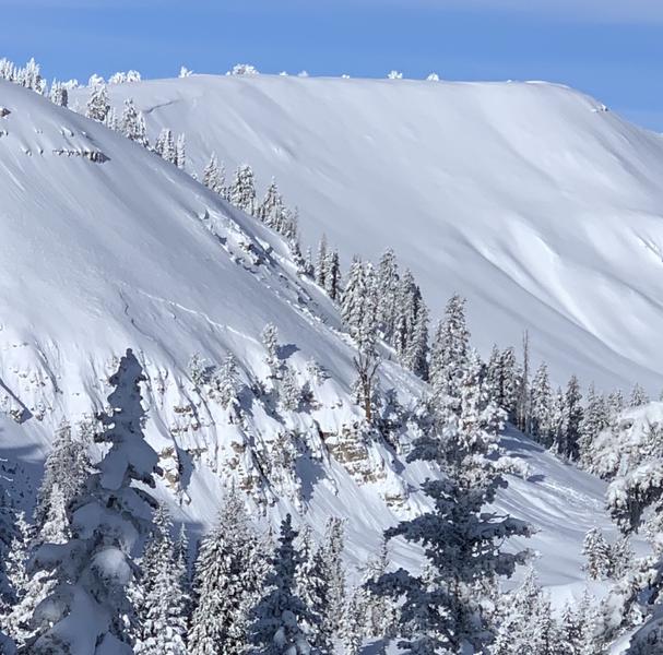
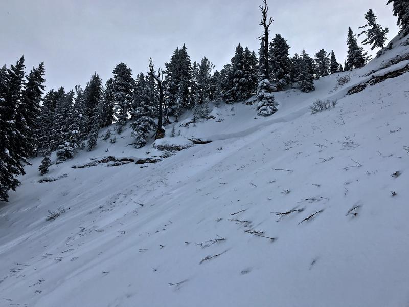
Looking at the crown of a recent natural avalanche in Miller Bowl, East (from Saturday) on a north facing slope at 8700'. The avalanche failed on a persistent weak layer near the ground.
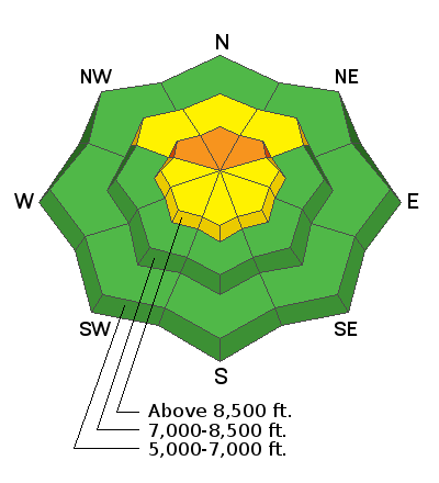
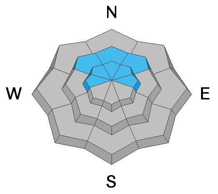
Expect sunny conditions in the mountains today, with 8500' high temperatures around 21°F, 6 mph west-southwest winds, and wind chills as low as -13°F. It will be partly cloudy tonight with low temperatures rising to around 13°F, 6 to 10 mph south winds, and wind chills around -4°F. It will be partly sunny on Wednesday, with high temperatures around 28°F, and south-southeast wind around 9 mph. Looks like a ridge of high pressure will settle in over the area for at least the next few days, with sun in the mountains and developing haze in the valleys. Heightened avalanche conditions exist on drifted slopes, with dangerous and destructive avalanches failing on a persistent weak layer possible on northerly facing upper elevation slopes.
Recent Avalanches
I'm sorry to report Utah's first avalanche fatality this season. On Sunday 12-15-19, a 45 year old male snowboarder was killed in a backcountry avalanche in Dutch Draw in the Wasatch Mountains above Park City. Preliminary Accident Report

Locally:
Natural activity from Saturday became apparent with clearing Sunday. Fairly widespread new snow and wind slab avalanches occurred across the zone and and we could see several large hard slabs releasing on sugary faceted October snow on high north and northeast facing slopes. Generally 3 to 4' deep and a few hundred feet wide, including Miller Bowl, East (above Tony Grove Lake) which took down some trees and ran to the flats. Recent large natural avalanches that failed on the Halloween persistent weak layer were also observed on Providence Peak, Naomi Peak, and Cornice Ridge.
Natural avalanche in "the Nose" on Cornice Ridge.
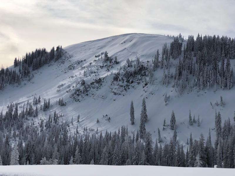
A large natural avalanche on the north face of Providence Peak.
Ad
Avalanche Problem #1
Wind Drifted Snow
Type
Location
Likelihood
Size
Description
Human triggered avalanches involving wind drifted snow are possible on upper elevation slopes.
  • Watch for and avoid stiffer drifted snow in and around terrain features like cliff bands, scoops, gully walls, and sub-ridges.
  • Drifted snow often appears smooth and chalky, and it can be hollow sounding like a drum.
  • Soft, fresh wind slabs are often quite sensitive, while harder wind slabs can be devious, sometimes allowing a person to get out on them before releasing.
  • Even small avalanches can be very dangerous in shallow snow conditions, because you could be dragged into rocks or stumps.
Avalanche Problem #2
Persistent Weak Layer
Type
Location
Likelihood
Size
Description
Very weak sugary, faceted snow from late October lurks near the ground at upper elevations on shady northerly facing slopes. Large, destructive, and very dangerous avalanches are possible where this poor snow structure exists. Dangerous avalanches on some slopes could be triggered remotely, from a distance, or below!
  • Cracking and collapsing are red flags indicating unstable snow conditions.
Large natural avalanches occurred on Saturday on several upper elevation northerly facing slopes. The avalanches failed on weak, sugary or faceted October snow near the ground.
General Announcements
Thanks to the generous support of our Utah ski resorts and Ski Utah, we have discount lift tickets available. All proceeds from these go towards paying for avalanche forecasting and education! Get your tickets HERE.
Consider taking an avalanche class, there are many different options. Click on the Education menu for a full list of classes from the UAC and other providers. Check out the Know Before You Go eLearning program for free, online, avalanche classes.... HERE
Need a Christmas present for your favorite backcountry partner? Get one of these cool t-shirts to support the UAC and other avalanche centers across the U.S. HERE
It's key to head into the early avalanche season with the proper mindset. In this podcast, we talk with UAC program director Bo Torrey. Bo talks about particular risks unique to the early season, tips and tricks for knocking the rust off your early season rescue skills, and charts out the path forward with avalanche education. HERE
EMAIL ADVISORY. If you would like to get the daily advisory by email you subscribe HERE.
Remember your information can save lives. If you see anything we should know about, please help us out by submitting snow and avalanche observations....HERE. You can also call us at 801-524-5304, email by clicking HERE, or include #utavy in your tweet or Instagram.