Get Your Ticket to the 32nd Annual Backcountry Benefit on September 11th! Support Forecasting, Awareness, and Education
Ad

Forecast: Logan Area Mountains

Forecast for the Logan Area Mountains

Toby Weed
Issued by Toby Weed on
Saturday morning, December 14, 2019
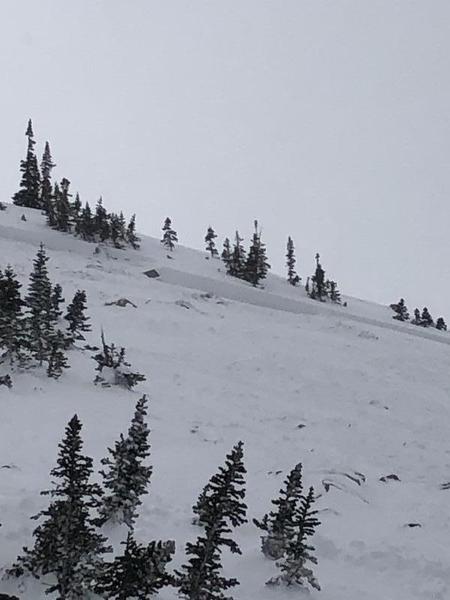
Heavy snow and strong westerly winds created dangerous avalanche conditions and HIGH danger in the backcountry. Avalanches of wind drifted snow and avalanches involving new snow are likely on many slopes. Natural activity is possible, especially during periods of particularly heavy snowfall this morning. Very dangerous conditions exist on drifted upper elevation slopes facing northwest, north, northeast, and east, with large avalanches failing on a persistent weak layer near the ground likely. You can find safer options on slopes less steep than about 30 degrees and in lower elevation and sheltered terrain, but avalanches are possible today on many slopes and at all elevations.
  • Avoid travel in backcountry avalanche terrain, including obvious or historic avalanche paths and run-out zones.
  • Stay off and out from under steep wind-drifted slopes.
Low
Moderate
Considerable
High
Extreme
Learn how to read the forecast here
Special Announcements
Beaver Mountain is closed to uphill traffic and all public use for set-up until opening day on Tuesday.
Weather and Snow
It's 26°F at the 8400' Tony Grove Snotel this morning, and there is about 8 inches of new snow, with .8" SWE in the past 24 hours and 3.4" so far from the storm. I'm reading 50 inches of total snow containing 128% of normal SWE for the date. It's 19°F at the 9700' CSI Logan Peak weather station, and west winds are blowing about 20 mph, with a 45 mph gust earlier this morning.

Expect more snow to fall in the mountains today, with 5 to 9 inches of additional accumulation possible. 8500' high temperatures will fall to around 17°F during the day, and 15 mph west-northwest winds are expected. Snow will taper off by evening, with mostly cloudy skies, low temperatures around 6°F, 7 to 11 mph north winds, and wind chills around -7°F. Snow showers are possible on Sunday, especially in the afternoon. Expect increasing clouds, high temperatures around 14°F, west-northwest winds 7 to 9 mph, and wind chills around -4°F. Dangerous avalanche conditions exist on many slopes this weekend. Avoid travel in upper elevation avalanche terrain.
Recent Avalanches
Yesterday in the Wasatch Mountains above Salt Lake City, a backcountry party had a very close call near Brighton in a backcountry area called Figure 8 Hill. A skier triggered and was caught and carried in a reported 3' deep and 100' avalanche that broke near the ground into the old weak early season snow. The skier came to rest with his head sticking out of the snow, but he had suffered a dislocated shoulder. Report is HERE

Locally:
Two riders were caught and carried, and one of them was partially buried in an avalanche just north of the Idaho State Line last Saturday afternoon 12-7-19. Here's the Report
Ad
Avalanche Problem #1
Wind Drifted Snow
Type
Location
Likelihood
Size
Description
West winds are blowing around 20 mph with a 45 mph gust on Logan Peak this morning. Fresh snow continues to be drifted on steep slopes and into lee slope deposition areas. Natural and human triggered avalanches involving wind drifted snow are likely today and possible at all elevations. Watch for and avoid stiffer drifted snow in and around terrain features like cliff bands, scoops, gully walls, and sub-ridges. Drifted snow often appears smooth and chalky, and it can be hollow sounding like a drum. Soft, fresh wind slabs are often quite sensitive, while harder wind slabs can be devious, sometimes allowing a person to get out on them before releasing.
  • Avoid and stay out from under steep slopes with recently drifted snow.
Avalanche Problem #2
New Snow
Type
Location
Likelihood
Size
Description
Loose snow and soft slab avalanches consisting of storm snow are likely as fresh snow continues to stack up on steep slopes today. Natural avalanches are possible, and they will be most likely during periods of particularly heavy snowfall this morning.
  • Even small avalanches can be very dangerous in shallow snow conditions, because you could be dragged into rocks or stumps.
  • Cracking and collapsing are red flags indicating unstable snow conditions.
Avalanche Problem #3
Persistent Weak Layer
Type
Location
Likelihood
Size
Description
Very weak sugary, faceted snow from late October lurks near the ground at upper elevations on shady northerly facing slopes. Large, destructive, and very dangerous avalanches are possible where this poor snow structure exists. Dangerous avalanches on some slopes could be triggered remotely, from a distance, or below!
General Announcements
The Tony Grove Road is not maintained for wheeled vehicles in the winter.
Thanks to the generous support of our Utah ski resorts and Ski Utah, we have discount lift tickets available. All proceeds from these go towards paying for avalanche forecasting and education! Get your tickets HERE.
Consider taking an avalanche class, there are many different options. Click on the Education menu for a full list of classes from the UAC and other providers. Check out the Know Before You Go eLearning program for free, online, avalanche classes.... HERE
Need a Christmas present for your favorite backcountry partner? Get one of these cool t-shirts to support the UAC and other avalanche centers across the U.S. HERE
It's key to head into the early avalanche season with the proper mindset. In this podcast, we talk with UAC program director Bo Torrey. Bo talks about particular risks unique to the early season, tips and tricks for knocking the rust off your early season rescue skills, and charts out the path forward with avalanche education. HERE
EMAIL ADVISORY. If you would like to get the daily advisory by email you subscribe HERE.
Remember your information can save lives. If you see anything we should know about, please help us out by submitting snow and avalanche observations....HERE. You can also call us at 801-524-5304, email by clicking HERE, or include #utavy in your tweet or Instagram.