Join us at our 2nd Annual Blizzard Ball

Forecast for the Logan Area Mountains

Toby Weed
Issued by Toby Weed on
Tuesday morning, November 19, 2024
There is still not enough snow to cover the rocks in the Bear River Range, but yesterday's heavy snowfall and more today could help. The avalanche danger is rising in the backcountry, and shallow avalanches of drifted new snow are possible on upper-elevation slopes that were snow-covered last weekend.
Low
Moderate
Considerable
High
Extreme
Learn how to read the forecast here
Special Announcements
Know Before You Go! Matt Barry will give a free avalanche awareness talk at the Logan Public Library tonight, November 19 at 7:00.
SAVE THE DATES!
Tuesday, December 3 - 21st Annual Pray for Snow fundraiser/party, Cache, Logan Information and tickets available here.
Wednesday, December 4 - USU KBYG (Know Before You Go) Night, USU ARC
Saturday, December 7 - 17th Annual Utah Snow and Avalanche Workshop (USAW) - Information and tickets available here.
Weather and Snow
  • We found shallow, very loose, sugary snow above 8000' in the Central Bear River Range Sunday. This snow is very weak, and as new snow stacks up, it will create avalanche concerns where it exists on smooth slopes steeper than about 30°.
  • 9" of snow fell at the 8500' Tony Grove Snotel in the last 24 hours, and there is now 19" of total snow. There is 22" at the 8800' UAC Card Canyon weather station.
  • The wind is blowing 13 mph with gusts of 22 from the west at Paris Peak and 18 mph with gusts to 32 mph at 9700' at the CSI Logan Peak weather station.
  • A Pacific Northwest storm system will bring periods of snow to northern Utah and southwest Wyoming through Tuesday. High pressure will return for the remainder of the week,
For more information, visit the UAC weather page here: Weather - Utah Avalanche Center
For Logan-specific weather go here: Logan Mountain Weather - Utah Avalanche Center
Recent Avalanches
No avalanches have been reported recently in the Logan Zone, but remember, avalanches are possible any time snow accumulates on slopes steeper than 30 degrees.
Ad
Avalanche Problem #1
New Snow
Type
Location
Likelihood
Size
Description
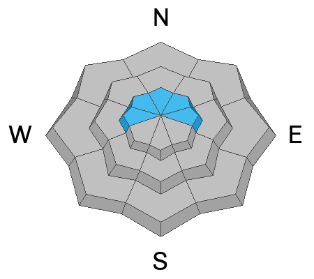
Shallow avalanches of drifted new snow are possible on slopes steeper than 30°.
Additional Information
The video is from last year, but the message is still good for the early season. Take the time now to check your companion rescue equipment and refresh your skills with backcountry partners...
General Announcements
-National Forest Winter Recreation Travel Maps show where it's open to ride: UWCNF Logan, Ogden LRD Tony Grove, Franklin Basin CTNF Montpelier
-Sign up for forecast region-specific text message alerts. You will receive messages about changing avalanche conditions, watches, and warnings...HERE.
-For all questions on forecasts, education, Know Before You Go, events, online purchases, or fundraising, call 801-365-5522.
-To report an avalanche or submit an observation from the backcountry, go HERE.
-Please continue to submit your observations from the backcountry so we can publish them and keep people informed of what you're seeing out there.

This forecast is from the U.S.D.A. Forest Service, which is solely responsible for its content. This forecast describes general avalanche conditions, and local variations always occur.