Join us at our 2nd Annual Blizzard Ball

Forecast for the Logan Area Mountains

Toby Weed
Issued by Toby Weed on
Wednesday morning, January 8, 2025
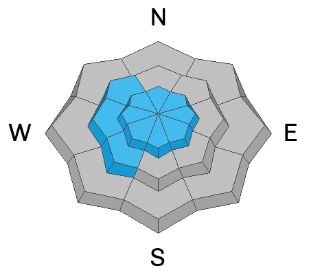
Although the snow is gradually becoming more stable, heightened avalanche conditions are widespread in mid and upper-elevation terrain, and people could trigger dangerous slab avalanches that fail on a persistent weak layer buried 1 to 3 feet deep. Areas with CONSIDERABLE avalanche danger exist on northerly facing upper-elevation slopes steeper than 30°.
Evaluate snow and terrain carefully, make conservative decisions, and continue to avoid drifted slopes with poor snow structure.
Low
Moderate
Considerable
High
Extreme
Learn how to read the forecast here
Special Announcements
Receive forecast region-specific text message alerts to receive messages about changing avalanche conditions, watches, and warnings. Sign up and update your preferences HERE
Weather and Snow
With poor snowpack structure still a major concern, human-triggered avalanches that fail 1 to 3 feet deep on a sugary, persistent weak layer near the ground are possible on many northerly-facing slopes at mid and upper elevations. Yesterday's winds blowing from the east created wind slabs in unusual or unexpected places. Avalanches failing on a persistent weak layer might still be triggered remotely (from a distance) or from below.
Observers reported several inches of very light fresh powder yesterday in the Garden City Canyon area west of Bear Lake. People can find good shallow powder riding and safer conditions in sheltered, low-angle terrain not connected to steep terrain. The danger is generally LOW below about 7000 feet, with very thin snow cover on southerly-facing slopes, which had little or no snow before last weekend.

-The 8400' Tony Grove Snotel reports 14° F, with 60 inches of total snow.
-On Logan Peak at 9700' feet the wind is blowing from the northwest around 10 to 15 mph, it's 12° F and the wind chill value is -2° F.
-It's 13° F at 8800' at our Card Canyon station, with a trace of new snow and 44 inches of total snow.
-On Paris Peak at 9500' in Bloomington Canyon, it is 11° F, and the wind sensor still appears to be rimed (or iced), so it's not working.
It'll be mostly sunny and cold in the mountains today. At 8500 feet, expect a high temperature of 25° F, with winds veering from the west-northwest, blowing 5 to 13 mph and possible wind chill values around -14° F.
Tonight, skies will be partly cloudy, with a low temperature around 7° F. Tomorrow will be sunny, with high temperatures around 25° F. Expect 6 to 10 mph winds from the northeast, and wind chill values as low as -7° F.
We'll see some sun and enjoy more benign weather for much of the work week, with some snow expected Friday night and Saturday.

For more information, visit the UAC weather page here: Weather - Utah Avalanche Center
For Logan-specific weather, go here: Logan Mountain Weather - Utah Avalanche Center
Recent Avalanches
We received a third-person report of a rider caught and carried in a large avalanche on Saturday, 1-4-2025, in Snowslide Canyon, north of the State Line. The rider was caught, deployed his airbag, was carried, and ended up on top of the debris. The sled was mostly buried and took a while to recover. We are still hoping to get more information about this close call. Remember, the information you share about avalanches you see or trigger could save lives.

The Davenport Hill and Porter Fork accident reports are complete. Our condolences go out to the victims' families and friends and all those affected by these tragic accidents.

You can read all recent local observations HERE.
Ad
Avalanche Problem #1
Persistent Weak Layer
Type
Location
Likelihood
Size
Description
Very weak faceted snow exists near the ground on almost all northerly-facing slopes at upper and mid-elevations. While definitive signs of instability like collapsing are waning, the buried, sugary, persistent weak layer and poor snowpack structure haven't gone anywhere. This is our top concern because people could still trigger large and potentially deadly avalanches.
  • Recent avalanches, shooting cracks, and collapsing (whumpfs) are signs of unstable snow, but these obvious signs of instability will not always be present when a large avalanche occurs.
  • Avalanches could be triggered remotely (from a distance) or worse, from below steep slopes in the flats.
Avalanche Problem #2
Wind Drifted Snow
Type
Location
Likelihood
Size
Description
Unusual winds blowing from the east yesterday created wind slabs in unexpected places. Be especially cautious in west-facing terrain loaded by drifted snow for the first time this season. Recent drifting created hard slabs of wind-drifted snow in exposed terrain. Wind slabs may have overloaded slopes with a buried persistent weak layer, and avalanches could be large and destructive. Other wind slab avalanches may break in a newer weak layer or at the old snow surface.
  • Avalanches of wind-drifted snow are most likely on the lee side of major ridges. The concern with yesterday's east wind turns to more westerly facing slopes.
  • Drifting may have formed new wind slabs in exposed terrain in unexpected or unusual places and in and around terrain features like cliff bands, sub-ridges, gullies, and scoops.
  • Soft wind slabs may be quite sensitive, and some may be remotely triggered. Stiffer wind slabs may allow you to get out onto them before releasing, like a giant mouse trap.
Additional Information
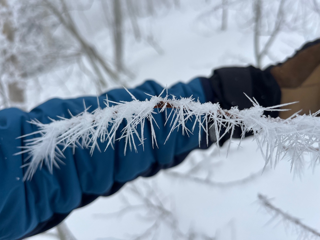
Monday, we found neat rime needle formations above 8000 feet in the foggy Providence Canyon forest. Rime occurs when water vapor freezes on exposed objects. Rime generally grows into the wind, but these needles can form in calmer conditions.
General Announcements
-National Forest Winter Recreation Travel Maps show where it's open to ride: UWCNF Logan, Ogden LRD Tony Grove, Franklin Basin CTNF Montpelier
-For all questions on forecasts, education, Know Before You Go, events, online purchases, or fundraising, call 801-365-5522.
-Remember the information you provide could save lives, especially if you see or trigger an avalanche. To report an avalanche or submit an observation from the backcountry, go HERE.
-The Tony Grove Road is not maintained for winter driving.

This forecast is from the U.S.D.A. Forest Service, which is solely responsible for its content. This forecast describes general avalanche conditions, and local variations always occur.