Join us at our 2nd Annual Blizzard Ball

Forecast for the Logan Area Mountains

Toby Weed
Issued by Toby Weed on
Tuesday morning, January 7, 2025
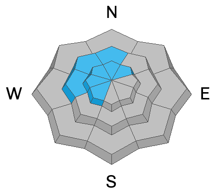
There is CONSIDERABLE avalanche danger on many northerly facing mid and upper-elevation slopes steeper than 30°. Although the snow is gradually becoming more stable, people are still likely to trigger dangerous slab avalanches that fail on a persistent weak layer buried 2 to 3 feet deep.
Good riding and safer conditions are found in the meadows, in sheltered terrain, and on lower angled slopes away from and out from under steep avalanche-prone terrain.
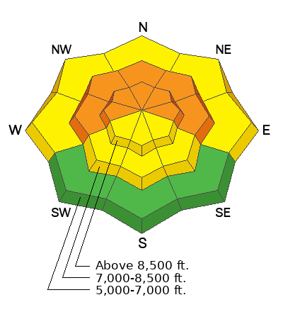
Low
Moderate
Considerable
High
Extreme
Learn how to read the forecast here
Weather and Snow
With poor snowpack structure still a major concern, human-triggered avalanches that fail 2 to 3 feet deep on a sugary persistent weak layer near the ground remain likely on many northerly-facing slopes at mid and upper elevations, especially where the wind recently loaded avalanche starting zones. Avalanches could be triggered remotely (from a distance) or from below.
We found good powder conditions, but not liking the overhead hazard and poor snow structure, we reevaluated our route and retreated from low in the Dog Leg Trees in Providence Canyon. People can find really good shallow powder riding and safer conditions in sheltered, low-angle terrain not connected to steep terrain. The snow is mostly supportable, and rocks, stumps, and downed trees are almost covered above about 8000'. Low-elevation terrain has very thin snow cover, especially on southerly-facing slopes that were bare of snow before the snow over the weekend.

-The 8400' Tony Grove Snotel reports 3" of new snow in the last 24 hours. It's 17° F, with 62 inches of total snow.
-Winds on Logan Peak ( 9700') are blowing from the east around 20 mph, and it's 11° F.
-It's 14° F at 8800' at our Card Canyon station, with 45 inches of total snow.
-On Paris Peak at 9500' in Bloomington Canyon, it is 10° F, and the wind sensor still appears to be rimed (or iced), so it's not working.
It'll be mostly sunny and cold in the mountains today. At 8500 feet, expect a high temperature of 20° F, with winds from the east blowing 11 mph and wind chill values around -11° F.
Tonight, skies will be mostly clear, with a low temperature around 5° F. Tomorrow will be mostly sunny, with high temperatures around 24° F. Expect 6 to 10 mph winds from the north-northeast, veering from the west in the afternoon, and wind chill values will be as low as -7° F.
We'll see some sun and enjoy more benign weather for much of the work week, with snow expected to resume Friday night and Saturday.

For more information, visit the UAC weather page here: Weather - Utah Avalanche Center
For Logan-specific weather, go here: Logan Mountain Weather - Utah Avalanche Center
Recent Avalanches
We've completed the Davenport Hill and Porter Fork accident reports. Our condolences go out to the victims' families and friends and all those affected by these tragic accidents.
We received a third-person report of a rider caught and carried in a large avalanche in Snowslide Canyon, north of the State Line. The rider was caught, deployed his airbag, was carried, and ended up on top of the debris.
The sled was mostly buried and took a while to extricate. We are still hoping to get more information about this close call. Remember, the information you share about avalanches could save lives.
You can read all recent local observations HERE.
Ad
Avalanche Problem #1
Persistent Weak Layer
Type
Location
Likelihood
Size
Description
Very weak faceted snow exists near the ground on almost all northerly-facing slopes at upper and mid-elevations. While definitive signs of instability like collapsing are waning, the poor snowpack structure hasn't gone anywhere. It is still our top concern and not to be trifled with. We need to give slopes with poor snow structure and a buried, persistent weak layer more time to heal.
  • Recent avalanches, shooting cracks, and collapsing (whumpfs) are signs of unstable snow, but these obvious signs of instability will not always be present when a large avalanche occurs.
  • Avalanches could be triggered remotely (from a distance) or worse, from below steep slopes in the flats.
Avalanche Problem #2
Wind Drifted Snow
Type
Location
Likelihood
Size
Description
Unusual winds blowing from the east today may create wind slabs in unexpected places. Be especially cautious in northwest and west-facing terrain that may be getting loaded by drifted snow for the first time this season. Recent drifting has created soft and hard slabs of wind-drifted snow in exposed terrain. Wind slabs may cause deeper avalanches to fail on our buried sugary persistent weak layer, or wind slabs may break in a newer weak layer at the old/new snow interface.
  • Avalanches of wind-drifted snow are most likely on the lee side of major ridges. The concern with today's east wind turns to more westerly facing slopes.
  • Drifting may have formed new wind slabs in exposed terrain in unexpected or unusual places and in and around terrain features like cliff bands, sub-ridges, gullies, and scoops.
  • Soft wind slabs may be quite sensitive, and some may be remotely triggered. Stiffer wind slabs may allow you to get out onto them before releasing, like a giant mouse trap.
Additional Information
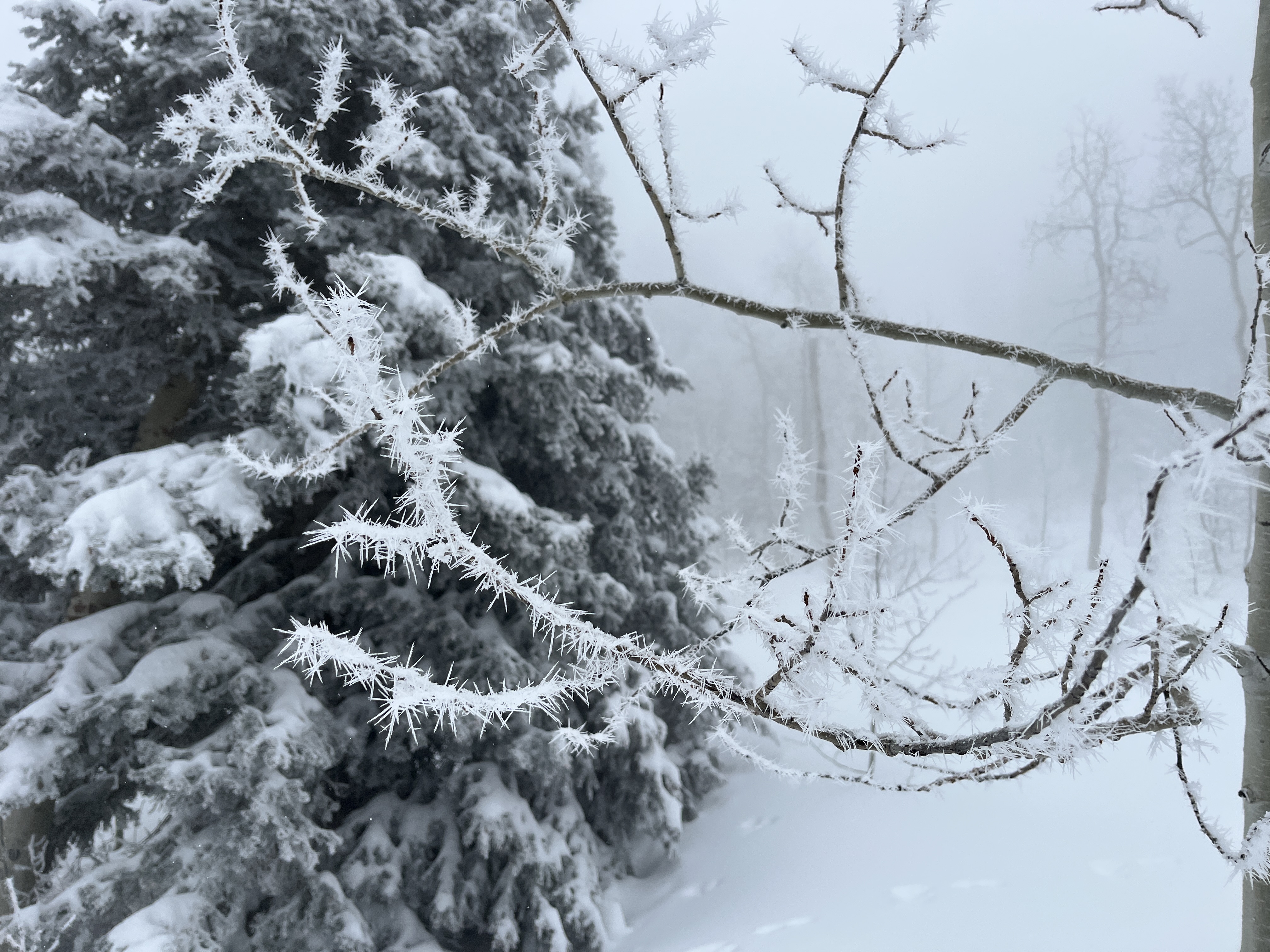
Yesterday, we found neat rime needle formations above 8000 feet in the foggy Providence Canyon forest. Rime occurs when water vapor freezes on exposed objects. Rime generally grows into the wind, but these needles can form in calm conditions.
General Announcements
-National Forest Winter Recreation Travel Maps show where it's open to ride: UWCNF Logan, Ogden LRD Tony Grove, Franklin Basin CTNF Montpelier
-Sign up for forecast region-specific text message alerts. You will receive messages about changing avalanche conditions, watches, and warnings...HERE.
-For all questions on forecasts, education, Know Before You Go, events, online purchases, or fundraising, call 801-365-5522.
-To report an avalanche or submit an observation from the backcountry, go HERE.
-Remember, even though the gate is still open, the Tony Grove Road is not maintained for winter driving.

This forecast is from the U.S.D.A. Forest Service, which is solely responsible for its content. This forecast describes general avalanche conditions, and local variations always occur.