Forecast for the Logan Area Mountains

Toby Weed
Issued by Toby Weed for
Saturday, January 12, 2019
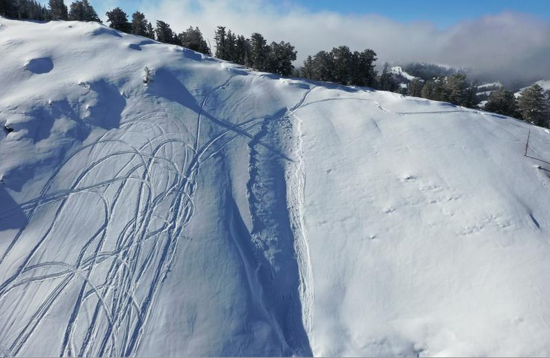
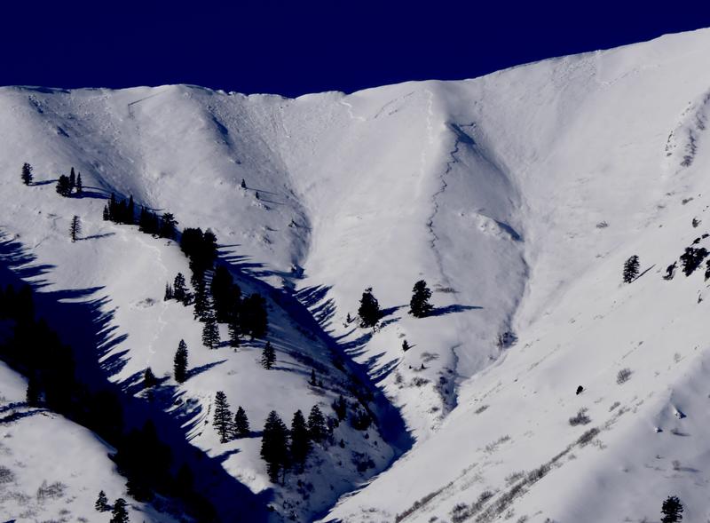
MODERATE: Snow stability is improving, but dangerous human triggered avalanches are still possible at all elevations in the backcountry. Heightened avalanche conditions exist on previously drifted slopes with buried persistent weak layers, and loose wet avalanches are possible in sunny terrain. Avalanches are possible on lower elevation slopes in areas where you might not expect to see one. Be extra careful in foothill areas where you might normally take the kids sledding or the dog for a walk.
  • Evaluate snow and terrain carefully, and continue to avoid steep slopes with previously wind drifted snow.
Low
Moderate
Considerable
High
Extreme
Learn how to read the forecast here
Weather and Snow
The snow is unstable on some lower elevation slopes and human triggered avalanches are possible in areas where they might threaten unsuspecting people.
The Tony Grove Snotel at 8400' reports 23º F and there's 48"of total snow containing 88% of average SWE. I'm reading 26º F at the 9700' CSI Logan Peak weather station, and northeast winds are currently averaging 5 to 10 mph.
High pressure will dominate the weather pattern through the weekend. A series of weather disturbances will finally return to the area toward the middle of the week. Today will be sunny with a light east wind and high temperatures at 8500' near 32º F.
Recent Avalanches
There were several triggered avalanches in the Logan Zone, and they all happened on Tuesday, 1/8/19.
  • 1/8, A skier triggered a good sized avalanche running on a persistent weak layer at low elevations on the North Logan Bench ...See Report HERE
  • 1/8, Deer triggered a couple avalanches in the River Heights Foothills.
  • 1/8, Riders triggered avalanches in the Naomi Peak and Egan Basin areas.


  • 1/8, A rider was caught and carried by a relatively small wind slab avalanche near the warming hut in Providence Canyon.

***Riders triggered a large avalanche in Providence Canyon last Friday, 1/4/19. Video report...... HERE

Natural avalanches were widespread across the zone during the windy storm 1/6 - 1/7. This is a look at Mendon Peak on 1/8/19
Ad
Avalanche Problem #1
Persistent Weak Layer
Type
Location
Likelihood
Size
Description
Earlier in the week, drifts built up on sugary or faceted persistent weak layers, and heightened avalanche conditions exist at all elevations. The shallow snow on the ground in many areas became loose, sugary, and faceted during the New Years cold spell. Slabs of harder snow formed on top of the loose faceted snow, and if you trigger an avalanche today it will likely step down into old snow and could be large and dangerous. Avalanches will most likely be directly triggered on very steep slopes with shallow snow and poor snow structure, but you might trigger one remotely, from a distance, or below. The sugary snow on many low elevation and mid elevation slopes will likely remain weak for a while.

Avalanche Problem #2
Wet Snow
Type
Location
Likelihood
Size
Description
Solar warming is causing the snow on sunny slopes to get moist and sloppy during the middle of the day. When the crust from overnight softens, the wet surface snow can become prone to loose avalanches, and these can entrain large piles of heavy snow on steep slopes. If you notice roller balls or natural sluffs, move off and out from under steep slopes with saturated surface snow.
Additional Information
I will update this forecast Monday morning.
General Announcements
The Beaver Mountain Backside is the backcountry, and it is avalanche terrain. If you cross the ski area boundary, you and your partners should carry and practice with avalanche rescue equipment.
Check out the improved weather links, road conditions, and weather links for each forecast region on the new UAC IOS App. Do you use the NOAA point forecast? If so, now you can bookmark your favorite weather locations in "My Weather" in the App. HERE
Are you new to the backcountry or looking to refresh your skills? The UAC has released a free 5-part avalanche skills eLearning series. HERE
Now is a great time to practice companion rescue techniques with your backcountry partners. Here is our practice video.
If you would like to get the daily advisory by email you subscribe HERE.
Support the UAC through your daily shopping. When you shop at Smith's, or online at REI, Backcountry.com, Patagonia, NRS, Amazon, eBay by clicking on these links, they donate a portion of your purchase to the UAC. If you sell on eBay, you can have your See our Affiliate Page for more details on how you can support the UAC when you shop
Remember your information can save lives. If you see anything we should know about, please help us out by submitting snow and avalanche observations. HERE You can call us at 801-524-5304, email by clicking HERE, or include #utavy in your Instagram.
This forecast is from the U.S.D.A. Forest Service, which is solely responsible for its content. The forecast describes general avalanche conditions and local variations always occur.