Forecast for the Abajos Area Mountains

Dave Garcia
Issued by Dave Garcia for
Tuesday, March 29, 2022
Four inches of snow overnight and strong Southerly winds have created a MODERATE danger for triggering an avalanche in wind drifted snow on slopes that face W-N-E near and above treeline. Backcountry riders should pay close attention to snowfall rates throughout the day. Fresh wind drifts will continue to form as the storm progresses. There is still a MODERATE danger for triggering an avalanche on a buried persistent weak layer of faceted snow on all steep slopes that face NW-N-E. Slopes that face due South have no snow, and adjacent slopes have a LOW danger.
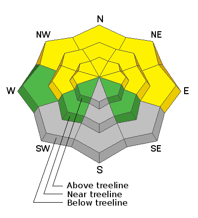
Low
Moderate
Considerable
High
Extreme
Learn how to read the forecast here
Special Announcements
Please help support avalanche forecasting throughout Utah. Donate to the Spring Campaign to help raise the funds to support the forecasting you rely on.
Weather and Snow
Cold temperatures have moved in and the overnight low was 20 degrees F. Winds have been blowing hard over night with gusts up to 40 mph. Today look for the wind to back off slightly and blow out of the S around 20 mph. Four inches of snow has fallen at so far. Snowfall will continue today and tonight. The models are in disagreement, but we should pick up another 4 to 7 inches before it's all said and done.
Snowpack
Four inches of new snow will give the surface a nice refresh. Solar aspects will most likely provide a dust on crust experience today. Northerly facing slopes will offer softer skiing, but there is still a buried persistent weak layer of sugary faceted snow on all slopes facing NW-N-NE-E. South winds will be blowing and drifting the new snow today, and backcountry riders will need to be on the lookout for newly formed wind drifts.
Snow totals and temps at Buckboard SNOTEL (8924')
Snow totals and temps at Camp Jackson SNOTEL (8858')
Recent Avalanches
There are no recent reports of avalanches from the Abajo range.
Avalanche Problem #1
Wind Drifted Snow
Type
Location
Likelihood
Size
Description
This morning you will find newly formed wind drifts near and above treeline on slopes that face West to North to East. South winds will continue to blow and drift snow today as new storm snow piles up. Fresh wind drifts will be developing throughout the day and look for the danger to increase this afternoon. Recently formed wind drifts will be soft and sensitive to triggers. Wind drifted snow is easily recognized by its smooth, rounded appearance.
Avalanche Problem #2
Persistent Weak Layer
Type
Location
Likelihood
Size
Description
A persistent weak layer of faceted snow still exists on NW-N-NE-E aspects beneath a slab that is 2'-3' thick. The weakest snow exists right around treeline and this is the most likely zone for triggering an avalanche. The big question is how did the buried PWL react to the unseasonably warm temperatures over the past few days. In the long term the warm temps should be good for stability, but I'm not ready to get into big terrain without some further investigation. Today you'll want to get out your shovel and see just what happened to the weak layer. There are likely a few areas with some lingering instabilities. I would be suspicious of any slopes that are still holding cold, dry facets.
General Announcements
Who's up for some free avalanche training? Get a refresher, become better prepared for an upcoming avalanche class, or just boost your skills. Go to https://learn.kbyg.org/ and scroll down to Step 2 for a series of interactive online avalanche courses produced by the UAC.
This forecast is from the U.S. Forest Service, which is solely responsible for its content. This forecast describes general avalanche conditions and local variations always occur.