Forecast for the Abajos Area Mountains

Dave Garcia
Issued by Dave Garcia for
Monday, March 28, 2022
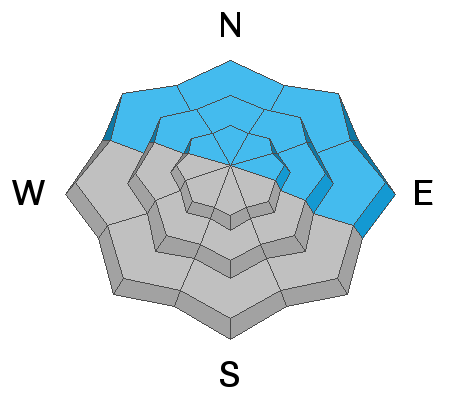
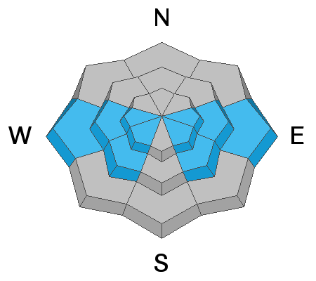
There is a MODERATE danger for triggering an avalanche failing on a buried persistent weak layer in steep terrain that faces NW-N-NE-E. An avalanche triggered on this layer can be 2-3 feet deep. On sunny slopes facing W-S-E the danger will rise to MODERATE for wet loose avalanches as the day warms up. Due south facing slopes are dry and bare of snow, but be on the lookout for signs of wet activity today on adjacent sunny slopes.
Low
Moderate
Considerable
High
Extreme
Learn how to read the forecast here
Special Announcements
Please help support avalanche forecasting throughout Utah. Donate to the Spring Campaign to help raise the funds to support the forecasting you rely on.
Weather and Snow
High clouds will be on the increase today ahead of the upper level system that will bring snowfall starting this evening. South winds will be ramping up ahead of the storm blowing in the 20-25 mph range with gusts up to 35 mph. We will have one more day of above average temperatures with highs in the low 40's. The incoming system will put an end to the heat wave and temperatures should drop to the low 20's tonight. Snow will continue Tuesday into Wednesday and I'm optimistic for an inch of water and maybe a foot of snow by Wednesday.
Snowpack
Over night temps dipped to the low 20's giving the mountains a good refreeze. You will find supportable crusts today on solar aspects. Corn skiing may or may not develop depending on how quickly the clouds build with the incoming storm. If the corn cycle develops we will have to be on the lookout for wet avalanche activity later in the day as temperatures rise. Reports from the alpine yesterday are of grabby, wind affected snow on North facing slopes above treeline. There is still some soft, medium density snow to be had out of the wind zone. On slopes facing NW-N-NE-E, we still have a persistent weak layer of sugary faceted snow that formed during the Jan-Feb dry period. The weakest snow exists right around treeline on slopes with a northeasterly component.
Snow totals and temps at Buckboard SNOTEL (8924')
Snow totals and temps at Camp Jackson SNOTEL (8858')
Recent Avalanches
There are no recent reports of avalanches from the Abajo range.
Avalanche Problem #1
Persistent Weak Layer
Type
Location
Likelihood
Size
Description
A persistent weak layer of dry, sugary faceted snow still exists on NW-N-NE-E aspects beneath a slab that is 2'-3' thick. The weakest snow exists right around treeline and this is the most likely zone for triggering an avalanche. Elsewhere, these avalanches are getting harder to trigger and there is some spatial variability associated with this weak layer. Some parties are still getting failures and propagation in snow pit tests, while others are not. One party even reported several large collapses on Saturday. This is the first report of collapsing in about two weeks and is a sign of our snowpack reacting to the near record warm temperatures over the past few days. We'll see above average temperatures again today and I'm going to continue to give this problem a wide berth for the time being.
Avalanche Problem #2
Wet Snow
Type
Location
Likelihood
Size
Description
South facing slopes are dry and have no snow. Warm temperatures and morning sunshine will create the potential for wet avalanche activity on adjacent sunny slopes. Increasing cloud cover today may keep wet activity in check. If you find yourself enjoying a corn cycle on solar aspects, then you need to be paying attention to signs of wet activity. If the slopes are getting wet, sloppy, and no longer support your weight, it's time to get off steep sunny terrain.
General Announcements
Who's up for some free avalanche training? Get a refresher, become better prepared for an upcoming avalanche class, or just boost your skills. Go to https://learn.kbyg.org/ and scroll down to Step 2 for a series of interactive online avalanche courses produced by the UAC.
This forecast is from the U.S. Forest Service, which is solely responsible for its content. This forecast describes general avalanche conditions and local variations always occur.