Forecast for the Abajos Area Mountains

Dave Garcia
Issued by Dave Garcia on
Wednesday morning, February 18, 2026

Dangerous avalanche conditions exist in the Abajo Range, and the avalanche danger is HIGH. Natural avalanches are likely, and human-triggered avalanches are very likely. Travel in avalanche terrain is not recommended. Avoid being on or beneath steep slopes. You can trigger avalanches from a distance, including slopes that are above you.

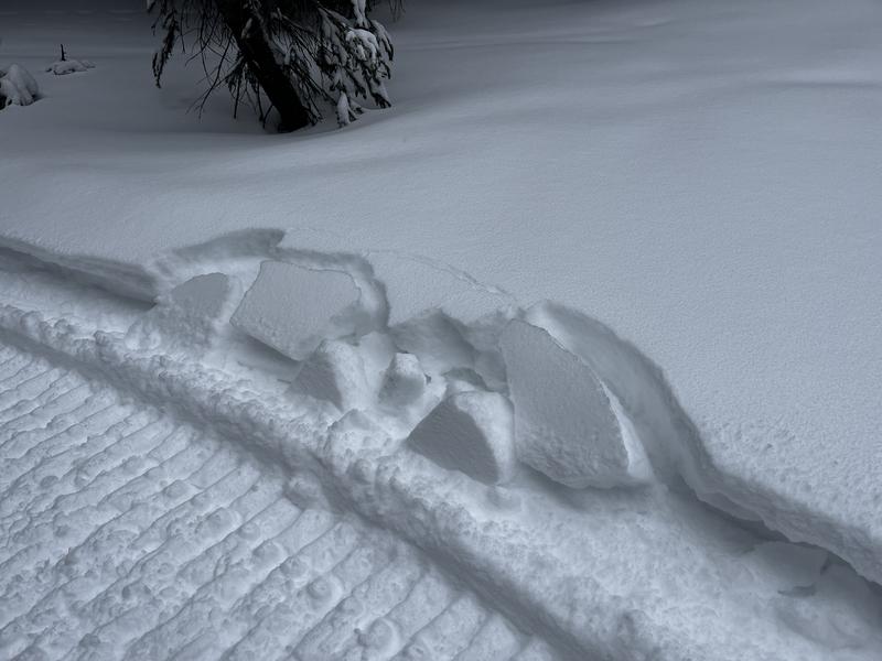
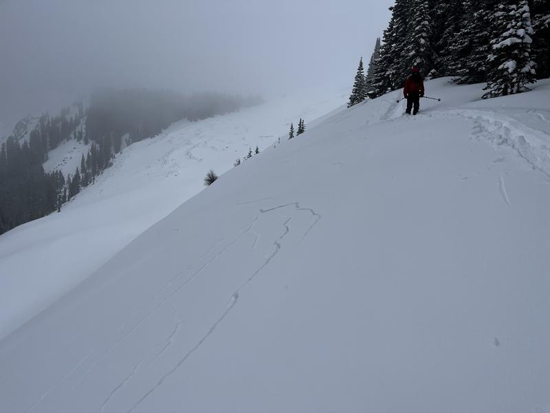
The Abajos have picked up six to eight inches of snow with 1 inch of snow water equivalent (SWE) since Monday. This may not sound like a lot of snow, but 1 inch of SWE is a significant load on what is a very weak and sensitive pre-existing snowpack. Any slope that previously held snow became very weak and faceted during the January dry spell. Slopes that face west to north to east harbor this weak structure. Strong southwest winds are adding to the problem. The same slopes that harbor weak snow are the same slopes that are being wind-loaded. Slabs of wind-drifted snow above weak facets will be sensitive and easy to trigger. The bullseye terrain for this is mid to upper-elevation slopes that face north to east. Today is not a day to try to outsmart any avalanche problems. Keep it simple and avoid avalanche terrain.

Low
Moderate
Considerable
High
Extreme
Learn how to read the forecast here
Special Announcements

SAVE THE DATES!

We are rescheduling our Moab Backcountry 101 Class to Feb 20, 21 in the hopes of more snow. Click here for information and registration. Moab and Monticello locals can use the discount code MOAB-LOCAL for a 10% discount.

Weather and Snow
NWS forecast for the Abajo Mountains.
Wind speed and direction on Abajo Peak.
Snow totals and temps at Buckboard Flat (8924')
Snow totals and temps at Camp Jackson (8858')
To learn more about recent snowfall history, you can read Eric's update from last week below:
It's been a lean year in the Abajos but snow is starting to trickle in with up to a foot of new snow up high since Feb 12. Prior to this storm, 1-2 feet of snow existed on shady aspects and this has become loose, weak, and faceted. South facing slopes were mostly bare. A stormy week ahead will add significant stress to this now buried, weak snow, and human triggered avalanches as well as possibly natural slides will become increasingly more likely over the coming days.
Blocks of snow outside of your sled track indicate slab formation.

Cracking in the snow surface is a sign of instability.

See all Abajo Observations here.
Additional Information
General Announcements
This forecast is from the U.S.D.A. Forest Service, which is solely responsible for its content. This forecast describes general avalanche conditions and local variations always occur.