Forecast for the Abajos Area Mountains

Eric Trenbeath
Issued by Eric Trenbeath for
Thursday, February 17, 2022
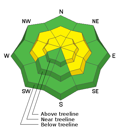
Unstable areas of new and wind drifted snow exist and the avalanche danger is MODERATE today on steep slopes at mid and upper elevations that had pre-existing snow on the ground. Look for unstable, fresh wind drifts on the leeward sides terrain features such as ridge crests, sub ridges, and gully walls. Dry, loose snow avalanches will be possible on steep slopes where 6" or more of fresh, low density snow is sitting on top of weak, sugary, near surface snow.
It's also still very low tide out there. Beware of rocks, stumps, and deadfall lurking beneath the surface.
Low
Moderate
Considerable
High
Extreme
Learn how to read the forecast here
Weather and Snow
Under promise and over deliver! Buckboard Snotel in lower North Creek is reporting 8" of new snow this morning with what looks like only about an inch on the south side of the range at Camp Jackson. Overnight, northerly winds blew in the 25-35 mph range with gusts to 50 for about five hours between 10:00 p.m. and 3:00 a.m. They've backed off a bit but will continue to blow in the 15-25 mph range along ridge tops with gusts to 35. Skies will be sunny and high temps will be in the low to mid 20's. High pressure returns for the weekend with an another storm brewing for early next week.
Snow totals and temps at Buckboard Flat (8924')
Snow totals and temps at Camp Jackson (8858')
Snowpack
Unstable areas of new and wind drifted snow will be found on steep slopes at mid and upper elevations. Look for fresh, unstable wind drifts on the leeward sides of terrain features such as ridge crests, sub ridges, and gully walls. Dry, loose snow avalanches will be possible on steep slopes where 6" or more of fresh, low density snow is sitting on top of weak, sugary, near surface facets.
Over the past several weeks, the snow surface has been subject to the ravages of wind and sun and conditions are variable. Depths across the range average 2'-3' deep above about 9000' on northerly aspects while many south facing slopes are bare. Snow on northerly facing slopes has grown weak and sugary near the surface, and slopes that have held snow since October, also have a weak, sugary, faceted layer at the base of the snowpack. In some areas, the entire snowpack is comprised of weak, sugary, faceted snow. Faceted snow creates weak layers in the snowpack and they are now getting covered up.
Avalanche Problem #1
Wind Drifted Snow
Type
Location
Likelihood
Size
Description
Unstable areas of wind drifted snow will be found on the leeward sides of terrain features such as ridge crests, sub ridges, and gully walls. Fresh drifts are recognizable by their smooth, rounded appearance and cracking is a sign of instability.
Avalanche Problem #2
New Snow
Type
Location
Likelihood
Size
Description
Dry, loose snow avalanches will be possible on steep slopes that received more than about 6" of new snow. This new, low density snow has landed on top of pre-existing sugary, facets. These types of avalanches should be mostly small and inconsequential, but they can entrain a fair amount of snow so beware of terrain traps such as gullys where snow can pile up.
General Announcements
Who's up for some free avalanche training? Get a refresher, become better prepared for an upcoming avalanche class, or just boost your skills. Go to https://learn.kbyg.org/ and scroll down to Step 2 for a series of interactive online avalanche courses produced by the UAC.
This forecast is from the U.S. Forest Service, which is solely responsible for its content. This forecast describes general avalanche conditions and local variations always occur.