Forecast for the Abajos Area Mountains

Eric Trenbeath
Issued by Eric Trenbeath for
Friday, December 21, 2018
Due to overall low snow coverage, the avalanche danger is generally LOW in the Abajo Mountains. There is a very isolated, or MODERATE avalanche danger on steep, upper elevation terrain that faces NW-N-E. In these areas, old snow from October has deteriorated into layers of weak, sugary, faceted snow that is providing an unstable base. There may also be a few stiff wind drifts in upper elevation, wind exposed terrain. Low snow conditions are in effect and backcountry travelers need to exercise caution in avoiding buried obstacles such as rocks and deadfall.
Low
Moderate
Considerable
High
Extreme
Learn how to read the forecast here
Special Announcements
Check out the new free online avalanche course series developed by the Utah Avalanche Center. This is a great way to refresh your skills or prepare you for a Backcountry 101 or Level 1 class.
Weather and Snow
High clouds have begun streaming into the area as the first in a series of weak storm systems moves through the region to the north. We'll see wind, and that's been the story for a few days now. Yesterday, ridge top winds from the WNW averaged 25 mph. They quieted down in the evening before shifting to the SW where they are currently averaging 20 mph with gusts to 30. Today we'll see partly sunny skies and continued breezy SW winds. Daytime highs will be around 30 degrees. We're still holding out hope for a decent storm for Christmas, but at this point the magnitude remains uncertain.
Snow conditions are still quite low for off-trail recreation.
Snow totals at Buckboard Flat (8924')
Snow totals at Camp Jackson (8858')
Wind, temperature, and humidity on Abajo Peak (11,000')
National Weather Service point forecast.
Avalanche Problem #1
Persistent Weak Layer
Type
Location
Likelihood
Size
Description
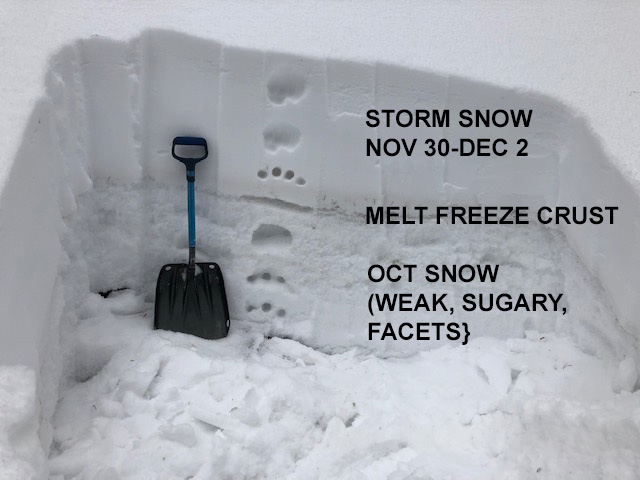
Snow that has sat around since October has deteriorated into a weak base of loose, sugary, faceted snow. You can find this weak snow on mid and upper elevation slopes that face NW-N-W. The photo below illustrates the early December snow, separated from the October snow by a melt freeze crust. Persistent weak layers of loose, sugary, faceted snow exist above, and below the crust. This is an unstable base. Though the danger is growing increasingly unlikely, human triggered avalanches, breaking down into this weak, sugary snow are still possible on steep, upper elevation slopes with a northerly aspect.
General Announcements
This advisory is from the U.S.D.A. Forest Service, which is solely responsible for its content. This advisory describes general avalanche conditions and local variations always occur.