Forecast for the Abajos Area Mountains

Eric Trenbeath
Issued by Eric Trenbeath for
Monday, January 21, 2019
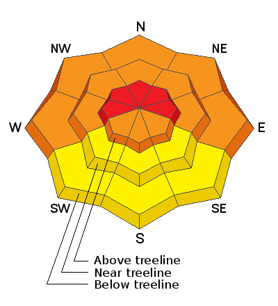
Blowing and drifting snow will cause the avalanche danger to rise to HIGH today in upper elevation, wind exposed terrain, particularly on slopes with a W-N-E aspect. Natural and human triggered avalanches are likely in these areas. At mid, and even lower elevations, the avalanche danger is CONSIDERABLE on steep, wind drifted slopes facing W-N-E, and human triggered avalanches are likely in these areas. Mid, and lower elevation, south facing terrain offers mostly MODERATE danger. Backcountry travelers today need to have excellent route finding skills and know how to stay off of, and out from under, avalanche prone terrain.
Low
Moderate
Considerable
High
Extreme
Learn how to read the forecast here
Special Announcements
We will be offering a Backcountry 101 avalanche course on Feb 8, 9. It's a great way to up your avalanche knowledge with both classroom, and hands on field instruction. Click here for more details and to register.
The new UAC IOS mobile app is now available on the app store. Check out the new "My Weather" feature.
Check out the new free online avalanche course series developed by the Utah Avalanche Center. This is a great way to refresh your skills or prepare you for a Backcountry 101 or Level 1 class.
Weather and Snow
A fast moving storm system will sweep through the region today and into early Tuesday morning. Snow totals for our area don't look particularly impressive, up to around 6", but the real story is the wind. SW winds began ramping up yesterday afternoon blowing in the 15-20 mph range with gusts to 40. Around midnight they swung around to the SE where they have continued to blow in the same range. Strong southerly winds will continue throughout the day with developing periods of snow showers. It looks to me like 2"-4" are possible by late afternoon. High temps today will be in the low 20's. Windy and snowy conditions will continue into tonight with snow tapering off after midnight. Another 2"-4" are possible. Temps will plummet into the single digits overnight, and winds will shift to the NW creating bone chilling conditions, with mostly sunny skies on Tues.
I'm afraid the excellent conditions of the past few days have taken a turn. Winds are hammering the snow surface, and stiff drifts, slabs, and crusts will be forming in all exposed locations. Best bet for soft snow will be found in very sheltered, mid and lower elevations.
Snowpack percentage of normal 115%
Snow totals at Buckboard Flat (8924')
Snow totals at Camp Jackson (8858')
Wind, temperature, and humidity on Abajo Peak (11,000')
National Weather Service point forecast.
Recent Avalanches
A large natural avalanche, 600-800' wide occurred on the big east face above Butler Flat. It occurred during the storm Thursday night.
General Announcements
Your information can save lives. If you see anything we should know about, please help us out by submitting snow and avalanche observations HERE. You can also call me at 801-647-8896, or send me an email: [email protected].
Support the UAC through your daily shopping. When you shop at Smith's, or online at REI, Backcountry.com, Patagonia, NRS, Amazon, eBay by clicking on these links, they donate a portion of your purchase to the UAC. If you sell on eBay, you can have your See our Affiliate Page for more details on how you can support the UAC when you shop
This advisory is from the U.S.D.A. Forest Service, which is solely responsible for its content. This advisory describes general avalanche conditions and local variations always occur.