Forecast for the Abajos Area Mountains

Eric Trenbeath
Issued by Eric Trenbeath for
Monday, January 2, 2023
Avalanche Warning
* WHAT...The avalanche danger is HIGH across northern, central, southeast, and southwest Utah.
* WHERE...For most mountains in Utah and southeast Idaho, including the Wasatch Range, Bear River Range, Uinta Range, Manti-Skyline, Fish Lake Region, La Sal and Abajo Mountains of Southeastern Utah, Pavant Range, Tushar Range, and Cedar City area mountains.
* WHEN...In effect from 6AM MST this morning to 6AM MST Tuesday
* IMPACTS...Very dangerous avalanche conditions exist. Natural and human triggered avalanches are likely on many slopes and may be triggered at a distance. Stay off of and out from under slopes steeper than 30 degrees.
Special Announcements
Heavy snowfall and strong southerly winds have created dangerous avalanche conditions in the Abajo Mountains. Natural and human triggered avalanches are likely. All avalanche terrain should be avoided. Stay off of and out from under slopes steeper than 30 degrees. Avoid avalanche run out zones and terrain traps such as gullies, canyon bottoms, or areas where avalanche debris can pile up.
Weather and Snow
The dump we've been waiting for has fallen on the Abajos with up to 2' of heavy, wet snow falling at upper elevations. Rain on snow has occurred at lower elevations and Camp Jackson is reporting 18" of snow at 4.0" of Snow Water Equivalent. Snowfall will continue through the day and linger into tonight with another 4"-8" possible.
NWS Forecast for the Abajo Mountains
Snow totals and temps at Buckboard Flat (8924')
Snow totals and temps at Camp Jackson (8858')

Snowpack Summary and General Conditions
DANGEROUS AVALANCHE CONDITIONS EXIST IN THE ABAJO MOUNTAINS!
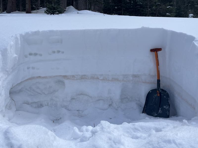
Heavy snowfall combined with wind has overloaded a weak, underlying snowpack creating dangerous avalanche conditions. Natural and human triggered avalanches are likely. A persistent weak layer of loose, sugary, faceted snow is buried in the snowpack. Dense, new and wind drifted snow has built thick, unstable slabs on top stressing this buried weak layer to it's breaking point. Very dangerous avalanche conditions exist. Backcountry travelers should avoid all avalanche terrain. Stay off of and out from under terrain steeper than 30 degrees. Avoid terrain traps such as gully walls, canyon bottoms, and avalanche run out zones.
The photo below illustrates the weak layer of loose, sugary, faceted snow that exists in the snowpack. All of the snow below the dust line is very weak and is incapable of supporting the added snow load from this most recent storm.
Additional Information
If you are getting out in the backcountry, we'd love to hear what you're seeing. Please submit observations here. For the most recent snowpack observations click here. You can also send an email to [email protected] or give me a call with anything noteworthy, especially avalanches! 801-647-8896
General Announcements
This forecast is from the U.S.D.A. Forest Service, which is solely responsible for its content. This forecast describes general avalanche conditions and local variations always occur.