Forecast for the Abajos Area Mountains

Eric Trenbeath
Issued by Eric Trenbeath for
Saturday, January 19, 2019
HEAVY SNOWFALL AND STRONG WINDS THIS WEEK HAVE CREATED DANGEROUS AVALANCHE CONDITIONS! The avalanche danger remains HIGH in upper elevation, wind exposed terrain. Deep and dangerous, human triggered avalanches are likely on steep, wind drifted slopes, especially on those slopes facing W-N-E. Out of the wind zone, the danger remains CONSIDERABLE. Backcountry travelers need to possess excellent route finding skills and know how to stay off of, and out from under, steep, avalanche prone terrain.
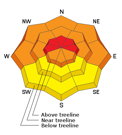
Low
Moderate
Considerable
High
Extreme
Learn how to read the forecast here
Special Announcements
We will be offering a Backcountry 101 avalanche course on Feb 8, 9. It's a great way to up your avalanche knowledge with both classroom, and hands on field instruction. Click here for more details and to register.
The new UAC IOS mobile app is now available on the app store. Check out the new "My Weather" feature.
Check out the new free online avalanche course series developed by the Utah Avalanche Center. This is a great way to refresh your skills or prepare you for a Backcountry 101 or Level 1 class.
Weather and Snow
The mountains picked up another 4"-6" of new snow Thursday bringing totals since Wednesday up to around 18". Skies will clear today. Ridge top winds are currently blowing out of the WNW averaging 10-15 mph, and temps are in the single digits. High temps today at 10,000' will be in the low 20's, but continued breezy, NW winds will keep the chill on. Sundy will be similar but with winds shifting to the SW ahead of the next storm currently on track for Monday.
I had a look around yesterday and observed signs of instabilty such as cracking in the snow surface and wind transported snow. We chose to stick to low angle terrain off the Hart's Draw Road and only ventured a short way up North Creek. The large avalanche above Buckboard Flat, and heavy wind transporting of snow kept our decisions conservative.
Snow totals at Buckboard Flat (8924')
Snow totals at Camp Jackson (8858')
Wind, temperature, and humidity on Abajo Peak (11,000')
National Weather Service point forecast.
Recent Avalanches
A large natural avalanche, 600-800' wide occurred on the big east face above Butler Flat. It occurred during the storm Thursday night.
General Announcements
Your information can save lives. If you see anything we should know about, please help us out by submitting snow and avalanche observations HERE. You can also call me at 801-647-8896, or send me an email: [email protected].
Support the UAC through your daily shopping. When you shop at Smith's, or online at REI, Backcountry.com, Patagonia, NRS, Amazon, eBay by clicking on these links, they donate a portion of your purchase to the UAC. If you sell on eBay, you can have your See our Affiliate Page for more details on how you can support the UAC when you shop
This advisory is from the U.S.D.A. Forest Service, which is solely responsible for its content. This advisory describes general avalanche conditions and local variations always occur.