Forecast for the Abajos Area Mountains

Eric Trenbeath
Issued by Eric Trenbeath for
Saturday, January 13, 2024
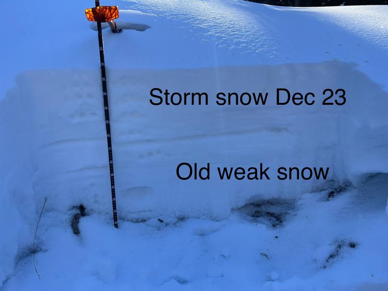
Dangerous conditons exist in the Abajo Mountains and human triggered avalanches, failing on a buried weak layer of sugary, faceted snow are likely on steep, northerly facing slopes. Human triggered avalanches involving unstable slabs of wind drifted snow are possible on all aspects. Wind slabs form on the leeward sides of ridge crests and terrain features such as gully walls and subridges. They are often recognizable by their smooth, rounded appearance, and cracking is a sign of instability. Avoid steep slopes that have recent deposits of wind drifted snow.
Low
Moderate
Considerable
High
Extreme
Learn how to read the forecast here
Special Announcements
Sign up for our Backcountry 101 course in the La Sal Mountains on Jan 19, 20!
Weather and Snow
The Abajo Mountains picked up more than 2' of snow over the past week. The underlying snowpack is very weak consisting of loose, sugary, faceted snow. The most recent storm snow has now settled into a cohesive slab over top of the weak, sugary snow underneath creating the perfect recipe for human triggered avalanches. The danger is greatest on steep, northerly facing slopes and human triggered avalanches are likely in these areas. Shifting strong winds over the past several days have also created unstable slabs of wind drifted snow. Wind slabs form on the leeward sides of ridge crests and terrain features such as gully walls and subridges. They are often recognizable by their smooth, rounded appearance, and cracking is a sign of instability. Avoid steep slopes that have recent deposits of wind drifted snow.
NWS forecast for the Abajo Mountains.
Snow totals and temps at Buckboard Flat (8924')
Snow totals and temps at Camp Jackson (8858')
Additional Information
The snowpit below was dug on a northeast aspect just below North Creek Pass on December 31, it shows a very weak, underlying snowpack of loose, sugary, faceted snow with the storm snow of December 23, on top. For now, all layers are soft. The most recent storm has piled 2' of new snow on top of this weak set up, and this is exactly what we need for avalanches to happen.
The entire snowpack, including the top layer of the most recent storm snow is soft, and is lacking a slab. We call this stable but weak.
This photo illustrates large, non-cohesive, sugary facets from the base of the snowpack.
General Announcements
This forecast is from the U.S.D.A. Forest Service, which is solely responsible for its content. This forecast describes general avalanche conditions and local variations always occur.