

Summary: A powerful atmospheric river event pummeled the Wasatch with a wet, windy, and warm storm last Friday night through early Sunday morning. This led to a widespread natural avalanche cycle of soft slabs failing 1-2 feet deep on our old persistent weak layer (PWL) of October and November facets. The avalanche danger spiked to HIGH on Saturday, with slow stabilization through the week. Unseasonably warm temperatures arrived late week, as wet avalanches made the problem list by Thursday.
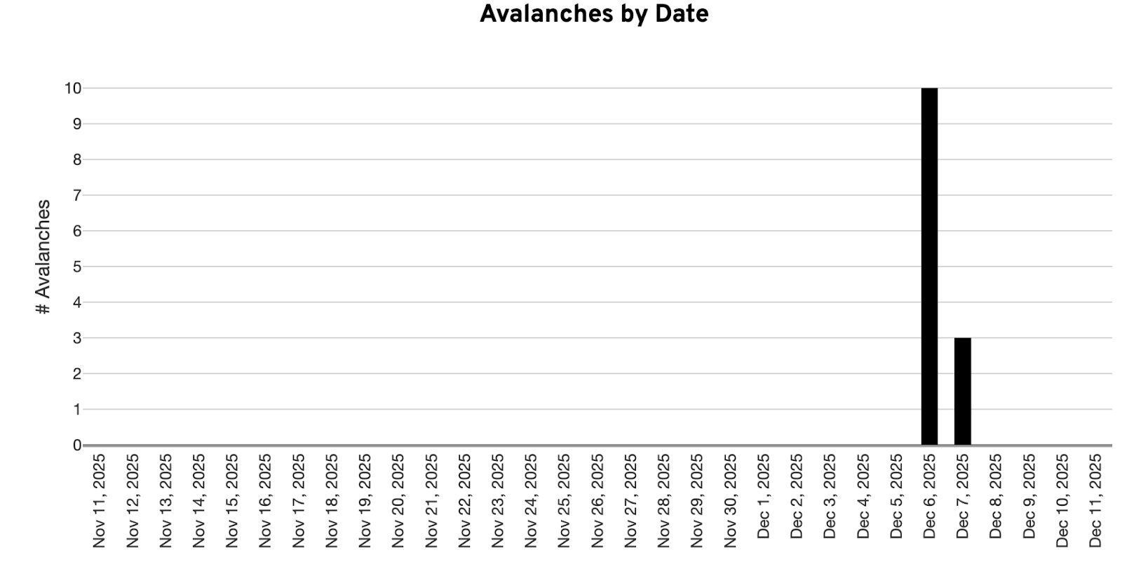
Reported avalanches on the PWL by date
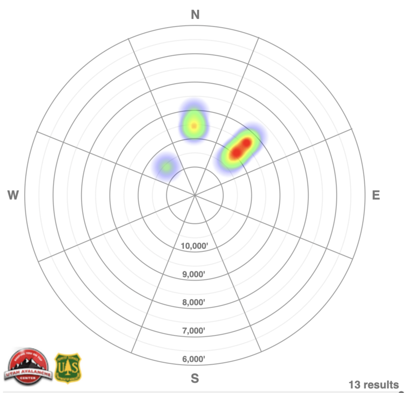
Reported avalanches on the PWL by aspect
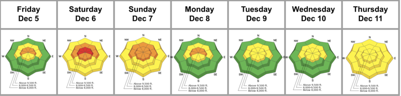
Friday: Strong winds from the northwest accompany the first hint of precipitation associated with a powerful atmospheric river event. By the afternoon, ski areas report a few pockety skier-triggered avalanches - some remotely triggered - in the alpine.
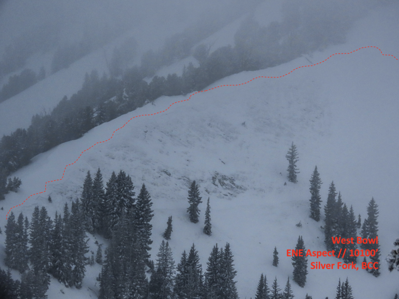
Saturday: Strong northwest winds accompany dense, upside-down Sierra cement. The upper Cottonwoods pick up 12-18 inches of snow with 2-3 inches of snow water equivalent, while the Park City ridgeline picks up about a foot of snow with an inch and a half of snow water equivalent. The danger quickly jumps to HIGH, and the northern, central, and southern Wasatch experience a widespread natural avalanche cycle on our persistent weak layer of facets. Backcountry tourers note cracking and collapsing everywhere the consolidated slab sits over the PWL. Forecaster Brooke Maushund’s photo below of a large natural that ran to the ground on the north headwall of West Bowl of Silver Fork.
Link to Trent’s video from East Bowl https://youtu.be/1EISoFrQxq8
Sunday: The danger drops to CONSIDERABLE. Skies begin to clear, and a couple more avalanches trickle in, but it’s mostly good sightseeing of the wreckage across the landscape. Cracking and collapsing remain the rule and not the exception.
Monday: No new avalanches reported from the backcountry, though there’s more good sightseeing of wreckage from Ogden to Provo. Moderate to strong northwest winds aloft continue to hammer the alpine.
Tuesday: The overall danger drops to MODERATE. Slow stabilization of our PWL problem. No new avalanches reported except for some pockety (“sneaky”) wind slabs triggered at the ski areas. Overcast skies, warm temps and green housing significantly damage all snow surfaces but high north. Those, however, had suffered wind damage over the past several days.
Wednesday: Continued slow stabilization of the PWL as snow tests offer “mixed results” and cracking and collapsing become more the exception and not the rule. The warming trend continues as some low and mid-elevation temps rise into the 40s and low 50s F. Ski areas and backcountry observers note extensive rollerballs, pinwheels, and some minor wet sluffing.
Thursday: The PWL problem is now described as “pockety” and stubborn. The Wet Snow Avalanche problem is added to the forecast as low and mid-elevations struggle to dip below freezing overnight.


