Following the wettest October in 150 years in the Central Wasatch, November has felt more like an extension of fall than a transition to winter. The weather pattern has sent a series of inland-penetrating storms into the Western US, yet many of them seemed to split just enough to skirt around the Wasatch, leaving us begging forgiveness from the jet stream. A small storm on November 17 managed to graze the state, producing six to twelve inches of snow across northern Utah. Since then, the cold temperatures and clear skies have been hard at work transforming the fallen snow into a menacing grain called facets. The danger with faceted snow isn’t immediate; it comes down the road after the layer is buried, and subsequent storms develop a cohesive slab above the layer.
Eventually, a change in the weather will bring storms to the area. When we begin to see strong winds and heavy snowfall, avalanche conditions will change, and the hazard will begin to increase.

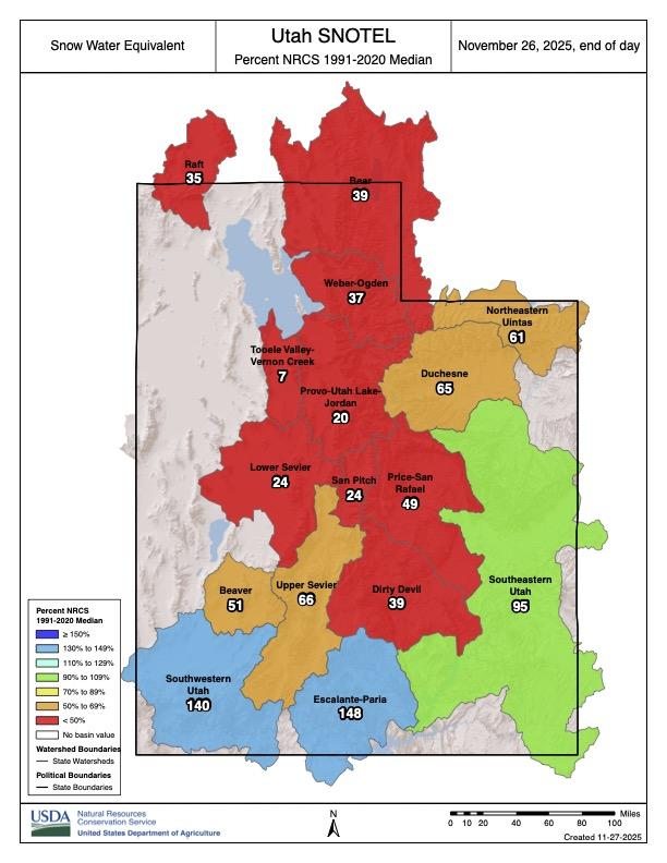
Image 1: Snow Water Equivalent percent of the Median value for this date.

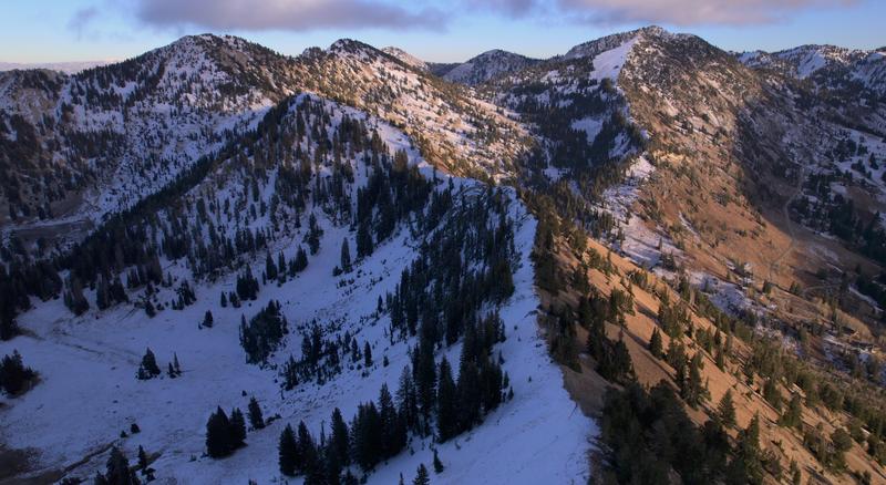
Image 2: An example of coverage confined to shady slopes above 9000 feet.
If the layer of facets was buried today, the greatest concern would be above 9000 feet on slopes facing northwest, north, northeast, and east. Here, snow depths range from six to twenty-four inches, and unless temperatures warm dramatically, this distribution is unlikely to change. The current setup is not unusual for Utah or much of the Intermountain West; we’ve experienced this early-season pattern several years in a row.

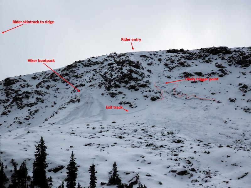
Image 3: A recent human-triggered avalanche from upper Red Pine in Little Cottonwood Canyon.
The layer has already produced an avalanche. The photo above is of an avalanche that was reported to us on 11/23. On Monday, November 24, Utah Avalanche Center Forecaster Brooke Maushund visited the site to investigate. This avalanche was triggered by a rider descending the slope and initially failed on a slab of wind-drifted snow before stepping down to a layer of faceted snow. The avalanche broke more than a foot deep and 150 feet wide. This is a northeast-facing slope at 10,600’. This slope is located just below a high-elevation ridge top, and strong southwest winds drifted additional snow onto this slope, creating the slab. The extremely low snow coverage and rocky ground cover make this an unforgiving slope. We love that folks are eager to get out and make some turns, but let this be a warning to all that avalanches are officially on the menu, and we expect many more.
The UAC is not putting out daily hazard ratings yet, but we are publishing intermittent updates and posting observations as they are submitted. While we await a pattern change, use the time to take note of the slopes that do and do not have snow coverage on them. The slopes that have snow will pose a greater hazard than those that are bare. Take the time to prepare your equipment, make sure your medical and rescue kits are resupplied, your transceiver, probe, and shovel are functioning properly, and that your mindset matches the challenging conditions we anticipate will develop when storms start to produce heavy snowfall.
The Wasatch is a magical range, and one storm can change things very quickly. Need a reminder? Visit Jim Steenburgh’s Blog for a recount of 100 inches in 100 hours.
Another related blog from the previous UAC Director, Mark Staples: Mapping early-season snow coverage


