
Nikki Champion
Forecaster
Week in Review: Avalanche Conditions and Snowpack Developments (February 21 - February 27, 2025)
Each week, we look back at the key snowfall, weather, and avalanche events from the previous week. For archived forecasts, visit the Salt Lake Mountains’ past updates.
Overall Summary:
The week was dominated by CONSIDERABLE avalanche danger, driven by multiple buried weak layers, wind-drifted snow, and increasing wet snow instabilities due to strong sunshine and warm temperatures. A Special Avalanche Bulletin remained in effect for several days following a week of heavy snowfall, which created excellent riding conditions but also heightened avalanche risk.
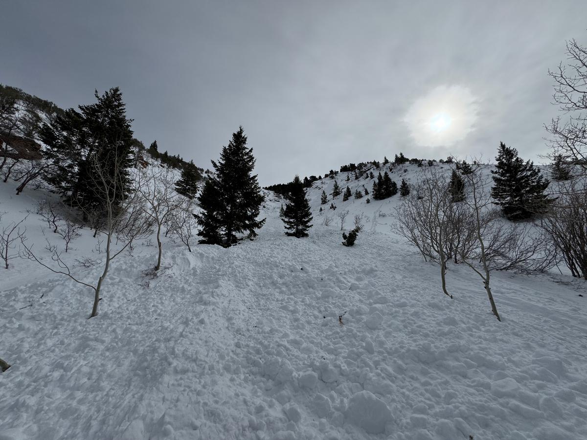
Persistent weak layers were the primary concern, with avalanches breaking several feet deep and over a hundred feet wide, particularly in thin snowpack areas and repeater slopes. Wind-drifted snow contributed to instability at higher elevations, while daily sunshine and warm temperatures fueled wet snow issues at lower elevations. Over the weekend, a large and eye-opening avalanche cycle unfolded, with numerous human-triggered and natural avalanches, including several near misses. A skier at Mt. Aire was caught, carried, and partially buried, sustaining injuries after hitting multiple trees. At Ant Knolls, two snowmobilers triggered a large slide that ran to the flats below. These incidents, along with widespread avalanches failing on different weak layers, underscored the instability and serious consequences of the conditions.
By midweek, increasing cloud cover and slightly cooler temperatures helped reduce wet snow activity, and avalanche danger began to ease. A weak storm system brought a minor drop in temperatures and some overnight wind but no significant snowfall. By Wednesday, avalanche danger dropped to MODERATE and remained there through the end of the week.
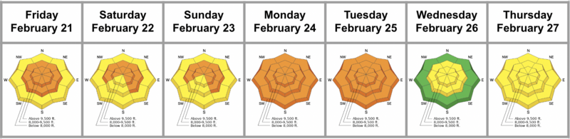
Friday, February 21
Avalanche danger was CONSIDERABLE at mid and upper elevations and MODERATE at lower elevations following a week of heavy snowfall. A Special Avalanche Bulletin was issued due to the combination of challenging avalanche conditions and clear skies. Persistent weak layers remained a concern, with avalanches capable of breaking several feet deep and over a hundred feet wide. Sensitive soft slabs and sluffing were reported across all elevations, along with pockets of wind-drifted snow at upper elevations.
With clear skies, a significant avalanche cycle unfolded, including lingering persistent weak layer failures on shaded, polar aspects and wet-loose avalanches on sun-exposed slopes. Many of these wet-loose slides initially started as dry-loose avalanches at higher elevations before transitioning downslope.
Notably, a skier-triggered soft slab in Little Cottonwood Canyon on the south-facing Goat began as a sluff but quickly picked up volume and force. Larger natural avalanches also occurred in Depth Hoar Bowl on a northeast aspect at 10,000 feet, likely triggered by a cornice drop. This slide appeared to fail on facets, though the exact timing remains uncertain.
Video of Near Miss in Little Cottonwood Canyon - the Goat
Saturday, February 22
Avalanche danger remained CONSIDERABLE, with the Special Avalanche Bulletin still in effect as another day of sunshine was forecast. Another impressive avalanche cycle unfolded, with multiple close calls—fortunately, everyone made it home safely after what could have been a tragic day in the backcountry. Both human-triggered and natural avalanches were observed across the entire range, including a large cycle down south into Provo and North into Ogden.
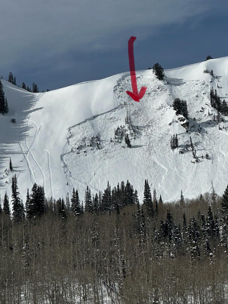
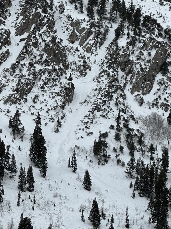
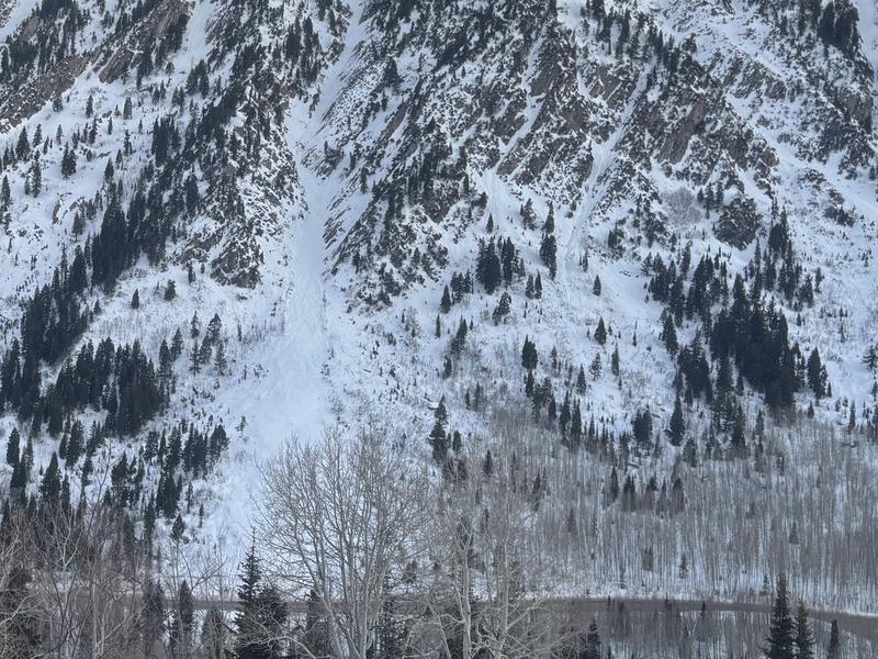
A large glide avalanche occurred in the Diving Board area. At Mt. Aire, a skier unintentionally triggered an 18-inch-deep, 150-foot-wide soft slab avalanche while ascending a north-facing ridge at 8,400 feet. He was carried 1,500 feet, partially buried, and sustained injuries after hitting multiple trees but was able to self-extricate and ski out with his partner.
At Ant Knolls, two snowmobilers triggered a 2–4 foot deep, 600-foot-wide soft slab avalanche on a northeast-facing slope at 9,600 feet. The slide ran 500 vertical feet to the flats below, exposing dirt and grass—evidence of failure on depth hoar near the base, likely on a repeater slope. The Mt. Aire avalanche failed on an unusual layer of precipitation particles, while the Ant Knolls avalanche failed on a persistent weak layer.
Near Miss on Mt. Aire
Near Miss on Ant Knoll - Ant Hill
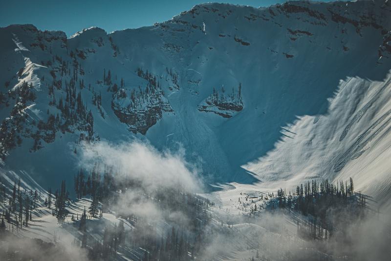
Large avalanche - Cascade Ridgeline
Sunday, February 23
Avalanche danger remained CONSIDERABLE as the Special Avalanche Bulletin stayed in effect for the final day of the weekend. Avalanche reports continued to trickle in from Saturday. Temperatures remained warm, but increased cloud cover and elevated winds led to rollerballing and greenhouse effects across the range, triggering a few additional large avalanches.
Monday, February 24
The Special Avalanche Bulletin was lifted, but strong sunshine led to increased avalanche danger, reaching CONSIDERABLE on all aspects and elevations. The main concerns were persistent weak layers, wind-drifted snow at higher elevations, and growing wet snow instabilities at lower elevations. The strong sun promoted widespread rollerballing and point releases, with small wet slab avalanches observed on Reynolds Peak.
Tuesday, February 25
Another day of full sun kept avalanche danger CONSIDERABLE across all aspects and elevations. The risk of triggering a deep and potentially deadly avalanche on a buried weak layer remained high, alongside lingering wind-drifted snow at higher elevations and wet snow instabilities. However, cooler temperatures and increased cloud cover helped mitigate the wet snow risk.
Wednesday, February 26
Avalanche danger dropped to MODERATE at mid and upper elevations and LOW at lower elevations as a slight low-pressure system moved through Tuesday night into Wednesday morning. This system brought a minor drop in temperatures, elevated overnight winds, and a brief snowfall—though no significant accumulation occurred. The day was quiet in the backcountry, with no major avalanche reports, but after several days of warm temperatures, riding conditions began to deteriorate.
Thursday, February 27
Following the passage of a weak cold front, avalanche danger increased to MODERATE across all aspects and elevations. Warm temperatures led to another round of wet-loose avalanches on solar aspects, with some large debris piles reported at the bottom of Superior.


