
Nikki Champion
Forecaster
Week in Review: Avalanche Conditions and Snowpack Developments (January 17th - January 23rd, 2025)
Each week, we look back at the key snowfall, weather, and avalanche events from the previous week. For archived forecasts, visit the Salt Lake Mountains’ past updates HERE.
Overall Summary:
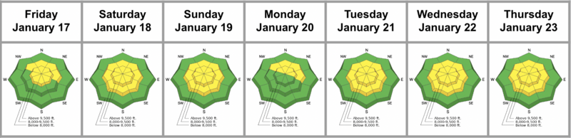
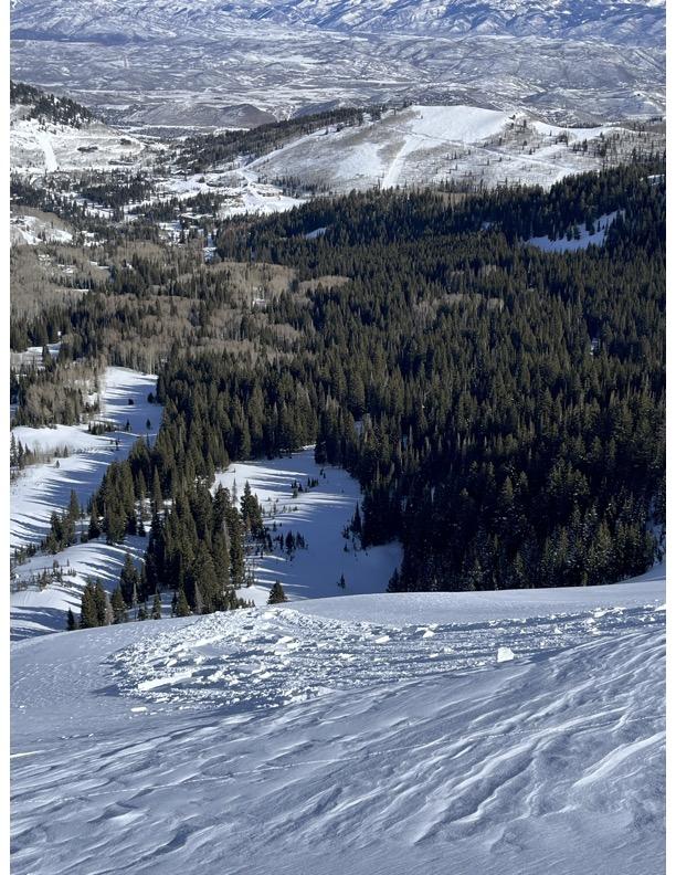
This week brought a mix of storms, strong winds, and frigid temperatures, with avalanche danger holding at MODERATE for mid and upper elevations. A sleeper storm on Saturday delivered 24 inches of low-density snow to the Upper Cottonwoods, leading to wind-drifted soft slabs and dry-loose avalanche potential in steep terrain. Persistent weak layers (PWLs) buried 2 to 4 feet deep on northwest through east aspects remained a lingering concern throughout the week.
This week brought a mix of storms, strong winds, and frigid temperatures, with avalanche danger holding at MODERATE for mid and upper elevations. A sleeper storm on Saturday delivered 24 inches of low-density snow to the Upper Cottonwoods, leading to wind-drifted soft slabs and dry-loose avalanche potential in steep terrain. Persistent weak layers (PWLs) buried 2 to 4 feet deep on northwest through east aspects remained a lingering concern throughout the week.
Reports included three intentionally triggered soft slabs on a north-facing slope at 8,700 feet, each approximately 2 feet deep and 40 feet wide. On Tuesday, a shallow wind-drifted slab was observed on a northeast aspect at 9,900 feet in West Monitor. On Wednesday, avalanche control work in Little Cottonwood Canyon produced a 2-foot-deep, 125-foot-wide slide in a heavily wind-loaded, northeast-facing starting zone, with additional natural wind slabs reported in upper Cardiac Bowl. The likelihood continues to drop for the persistent weak layer.
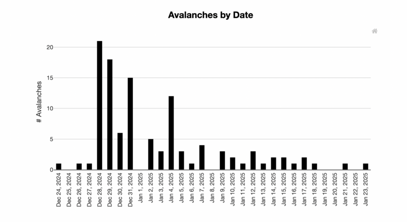
See the last month of avalanches in the Salt Lake Area.
Friday, January 17
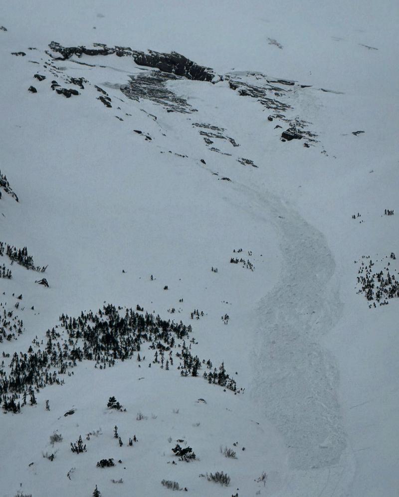
A generally quiet, overcast prefrontal day. Winds increased throughout the day, with gusts near 50 mph along ridgelines. Avalanche danger was rated MODERATE at mid and upper elevations due to the persistent weak layer (PWL) on west, north, and east-facing aspects and shallow slabs at the upper elevations. No new human-triggered avalanches were reported, though Mark White observed a glide avalanche in Broads Fork.
Glide avalanche from Broads Fork - M. White
Saturday, January 18
Another sleeper storm delivered 24 inches of snow, favoring the Upper Cottonwoods with the aid of Lake Effect. A cold snap began to move across the state, with temperatures hovering near zero and wind chills well below zero. Avalanche danger remained MODERATE, driven by fresh wind-drifted soft slabs and the potential for dry-loose avalanches in steep terrain with the new low-density snow. Additionally, buried persistent weak layers 2 to 4 feet deep on northwest through east aspects at mid and upper elevations could still be triggered. A group reported intentionally triggering three soft slabs of wind-drifted snow on a north-facing slope in West Scotties at 8,700 feet. These slabs were roughly 2 feet deep and 40 feet wide.
Soft slabs of Wind drifted snow of West Scotties
Sunday, January 19
Temperatures remained very cold, with mainly cloudy skies and occasional flurries. Avalanche danger continued at MODERATE due to wind-drifted snow and the lingering PWL.
Monday, January 20
The sun emerged though temperatures remained very cold. Solar radiation contributed to a slight melt-freeze crust on some aspects, while a wind crust formed on others. The likelihood of triggering the persistent weak layer continued to decrease. Avalanche danger remained MODERATE, driven by wind-drifted snow and the PWL.
Tuesday, January 21
Another very cold day, with high winds sweeping the range. Peak gusts reached up to 100 mph along the highest ridgelines. Avalanche danger stayed at MODERATE for mid and upper elevations. One report detailed a shallow slab of wind-drifted snow in West Monitor on a northeast aspect at 9,900 feet along the Park City Ridgeline.
Shallow wind drift in West Monitor
Wednesday, January 22
A cold but beautiful day unfolded. Avalanche danger stayed at MODERATE due to elevated winds and the lingering PWL. Avalanche control work in upper Little Cottonwood Canyon (LCC) produced a 2-foot-deep, 125-foot-wide avalanche in a heavily wind-loaded, northeast-facing starting zone. Ski guides also observed fresh, natural wind slabs in upper Cardiac Bowl.
Thursday, January 23
Temperatures began to rise toward seasonal averages, and winds finally decreased after an impressive 72-hour period. Avalanche danger remained MODERATE at mid and upper elevations for wind-drifted snow and the persistent weak layer. Although the likelihood of triggering the PWL has significantly decreased over the past week, the snow surface is also beginning to weaken.
A skier unintentionally triggered a hard slab avalanche on a north-facing slope at 9,800' in South Monitor Bowl, Park City Ridgeline, measuring 2' deep and 200' wide, caused by wind-drifted snow over a density change, resulting in one person being caught, carried, lost gear and sustained injuries but able to self-evacuate. UAC staff will visit the site on Friday and more details will be provided.


