Nikki Champion
Forecaster
Week in Review: Avalanche Conditions and Snowpack Developments (January 3rd - January 9th, 2025)
Each week, we look back at the key snowfall, weather, and avalanche events from the previous week. For archived forecasts, visit the Salt Lake Mountains’ past updates HERE.

Overall Summary: Over the week of January 3–9, the Wasatch saw constantly shifting avalanche conditions driven by storms, wind, and a fragile snowpack. Danger dropped briefly to CONSIDERABLE on the 3rd as skies cleared, but a fast-hitting storm on the 4th brought nearly 20 inches of snow and bumped danger back to HIGH at upper elevations. Widespread cracking, collapsing, and large avalanches highlighted how touchy the snowpack remained. As snowfall tapered off, instability lingered, with continued reports of red flags like collapsing and both natural and human-triggered avalanches. Winds, including pesky easterlies, kept things tricky by forming sensitive wind slabs in areas we rarely see in the Wasatch. By the 9th, fewer obvious signs of instability were seen in the backcountry, and the snowpack had begun showing some signs of slow stabilization and strengthening, though the consequences of triggering an avalanche were still significant.
Friday, January 3rd
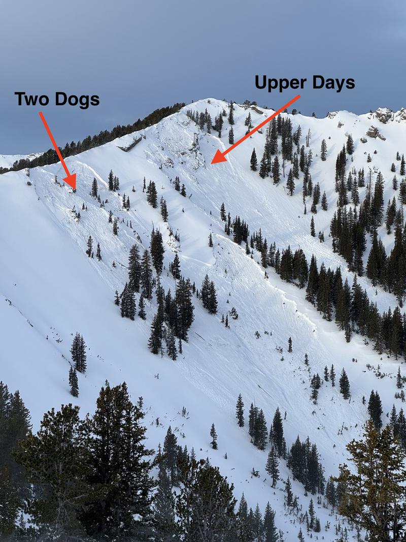
As stormy weather cleared, the avalanche danger eased from nearly a week at HIGH to CONSIDERABLE across mid and upper elevations. Sunshine returned, offering a reprieve and setting the stage for another weekend storm. The Upper Days Fork avalanches were likely triggered remotely from the ridge or by a cornice fall. Overnight, a natural avalanche occurred on a southeast aspect of Mt. Superior, triggered by a cornice fall from above due to wind.
As stormy weather cleared, the avalanche danger eased from nearly a week at HIGH to CONSIDERABLE across mid and upper elevations. Sunshine returned, offering a reprieve and setting the stage for another weekend storm. The Upper Days Fork avalanches were likely triggered remotely from the ridge or by a cornice fall. Overnight, a natural avalanche occurred on a southeast aspect of Mt. Superior, triggered by a cornice fall from above due to wind.
The Upper Days & Two Dogs avalanches reported on January 3rd - NE Aspect - 10,400' - Gagne
Saturday, January 4th
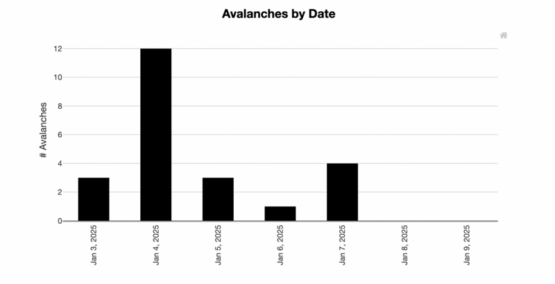
An impressive, fast-moving storm swept into the Wasatch, delivering nearly 20 inches of snow and 1.32 inches of water in less than five hours, with the Upper Cottonwoods receiving the brunt of the snowfall. Avalanche danger spiked to HIGH at upper elevations and remained CONSIDERABLE at mid-elevations due to the fresh snow and significant wind drifting. Early reports indicated widespread cracking and collapsing during the storm's peak. As skies cleared later in the weekend, close to 12 large avalanches—such as the initial Caradiac Ridge slide—were documented across the range, likely occurring during Saturday's peak instability. Find the whole list of recent avalanches HERE.
An impressive, fast-moving storm swept into the Wasatch, delivering nearly 20 inches of snow and 1.32 inches of water in less than five hours, with the Upper Cottonwoods receiving the brunt of the snowfall. Avalanche danger spiked to HIGH at upper elevations and remained CONSIDERABLE at mid-elevations due to the fresh snow and significant wind drifting. Early reports indicated widespread cracking and collapsing during the storm's peak. As skies cleared later in the weekend, close to 12 large avalanches—such as the initial Caradiac Ridge slide—were documented across the range, likely occurring during Saturday's peak instability. Find the whole list of recent avalanches HERE.
Avalanches for the Salt Lake Area mountains January 3rd-9th, 2025 - Avalanche Explorer

Sunday, January 5th
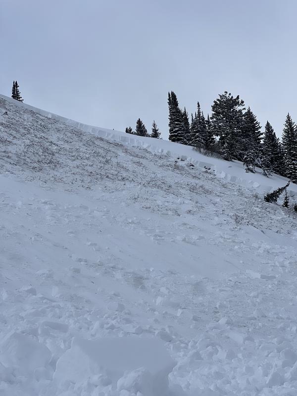
An additional inch of snow fell overnight, with a few more inches during the day under cloudy skies. Many parties in the backcountry still observed widespread cracking and collapsing. Avalanche danger remained HIGH at upper elevations. On the Wasatch back near the Ant Knolls, a party of snowmobilers triggered a large avalanche from below that ripped to the ground.
An additional inch of snow fell overnight, with a few more inches during the day under cloudy skies. Many parties in the backcountry still observed widespread cracking and collapsing. Avalanche danger remained HIGH at upper elevations. On the Wasatch back near the Ant Knolls, a party of snowmobilers triggered a large avalanche from below that ripped to the ground.
The Ant Knolls Avalanche that ripped to the ground - 9300' - NE Aspect - Pressman/Basham & Dell

Monday, January 6th
With the storm cycle tapering off, avalanche danger began to ease, dropping to CONSIDERABLE, though the consequences of triggering an avalanche remained significant. Reports of recent avalanches and other red flags, such as cracking and collapsing, continued across the range. Overcast skies helped preserve cooler temperatures.
With the storm cycle tapering off, avalanche danger began to ease, dropping to CONSIDERABLE, though the consequences of triggering an avalanche remained significant. Reports of recent avalanches and other red flags, such as cracking and collapsing, continued across the range. Overcast skies helped preserve cooler temperatures.
Tuesday, January 7th
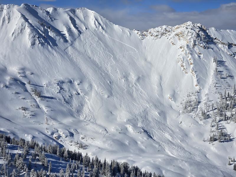
Avalanche danger held steady at CONSIDERABLE under sunny skies and cool temperatures. However, the Wasatch’s least-favorite wind direction—easterly—made an appearance. While not overly destructive, these winds contributed to localized instabilities, including sensitive soft slabs of wind-drifted snow. A notable natural avalanche was observed in Cardiac Ridge, highlighting the persistent weak layer problem.
Avalanche danger held steady at CONSIDERABLE under sunny skies and cool temperatures. However, the Wasatch’s least-favorite wind direction—easterly—made an appearance. While not overly destructive, these winds contributed to localized instabilities, including sensitive soft slabs of wind-drifted snow. A notable natural avalanche was observed in Cardiac Ridge, highlighting the persistent weak layer problem.
The secondary large avalanche on Cardiac Ridge - running close to 1000' wide - naturally triggered sometime before the morning of the 7th - Fullmer

Wednesday, January 8th
Winds shifted to the northwest and intensified throughout the day, reaching speeds of up to 70 mph at upper elevations by evening. The avalanche danger remained at CONSIDERABLE, though reports of new avalanches and instabilities (such as collapsing/cracking) became less frequent.
Winds shifted to the northwest and intensified throughout the day, reaching speeds of up to 70 mph at upper elevations by evening. The avalanche danger remained at CONSIDERABLE, though reports of new avalanches and instabilities (such as collapsing/cracking) became less frequent.
Thursday, January 9th
Easterly winds returned, producing a few unusual wind slabs on west-facing slopes. Although fewer signs of instability were reported during backcountry travel and snowpit assessments, the snowpack remains in a transitional phase. It's important to remember we are just days removed from a significant loading event. While the likelihood of triggering an avalanche has decreased, the consequences remain just as severe. Avalanche danger stayed at CONSIDERABLE, edging toward a tenuous MODERATE rating.
Easterly winds returned, producing a few unusual wind slabs on west-facing slopes. Although fewer signs of instability were reported during backcountry travel and snowpit assessments, the snowpack remains in a transitional phase. It's important to remember we are just days removed from a significant loading event. While the likelihood of triggering an avalanche has decreased, the consequences remain just as severe. Avalanche danger stayed at CONSIDERABLE, edging toward a tenuous MODERATE rating.


