Forecast for the Salt Lake Area Mountains

Greg Gagne
Issued by Greg Gagne for
Friday, December 22, 2017

The avalanche danger is MODERATE today - human triggered avalanches are possible on steep upper elevation slopes with recent wind drifts. These drifts may be found on a variety of aspects, but will be most common on those with a westerly component. Outside of wind-affected terrain the hazard is LOW.

Due to the shallow snowpack, being caught and carried by even a small avalanche could be very dangerous, as you will be dragged through shallowly buried rocks or downed trees.

Low
Moderate
Considerable
High
Extreme
Learn how to read the forecast here
Special Announcements

For the 2017/2018 winter, we're excited to introduce the Utah Avalanche Center podcast, hosted by forecaster Drew Hardesty and produced by KUER's Benjamin Bombard. On the podcast, you'll find engaging stories, interviews, and lessons learned - all things avalanche, all to help keep people on top of the greatest snow on earth instead of buried beneath it - and easily found on ITunes, Stitcher, the UAC blog, or wherever you get your podcasts. You can find the first podcast, released this week here.

Drew also has written a blog entry "Those Who Cannot Remember the Past ....". This important discussion highlights the relationship between years with lean snowpack and an increase in avalanche fatalities. You can read it here.

Don’t know what to buy your favorite skier for Christmas? Discount lift tickets for Alta, Snowbird, Brighton, Solitude, Deer Valley, Snowbasin,and Beaver Mountain are now available, donated by the resorts to benefit the Utah Avalanche Center. Details and order information here. These make a great holiday gift and all proceeds go towards paying for avalanche forecasting and education!

Weather and Snow

As of 5 am, temperatures are currently in the low teens, with some colder air pooling at low elevation trailheads where the temperatures remain stuck in the single digits. Winds are out of the northwest, and are generally light at the low and mid elevations. Above 10,000' winds are gusting into the teens and low 20's mph, with 11,000' winds gusting into the 30's and low 40's mph.

The fresh snow from Wednesday will have hidden the numerous rocks and stumps that accompany our shallow snowpack – which is only 1 to 2 feet deep on the shady, mid and upper elevation slopes. Most southerly facing slopes were bare before the Wednesday night storm.

Week in Review

> Saturday Dec 16 the Wasatch mountains picked up a trace to 2" of very low-density snow.

> Quiet weather Sunday through Tuesday.

> Strong south and southwest winds on Wednesday ushered in a cold front that arrived late Wednesday afternoon. Storm and water totals by Thursday included:

  • Provo mountains : 3" / 0.3"
  • Central Wasatch : 4-9" / 0.3 - 0.4"
  • Ogden mountains : 2-5" / 0.05 - 0.25"
Recent Avalanches

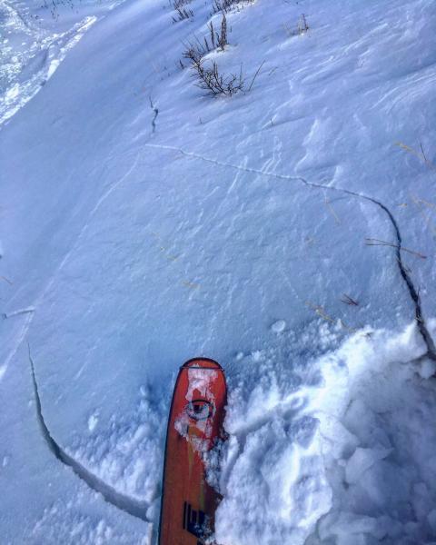
No new avalanche activity has been reported from Thursday. However, we did receive a report from mid elevations in Little Cottonwood Canyon of collapsing at the deeper weak layers in our snowpack.

Ad
Avalanche Problem #1
Wind Drifted Snow
Type
Location
Likelihood
Size
Description

Winds out of the north and northeast blew along the upper elevation ridges on Thursday, creating dense wind drifts up to 18". (See Mark White's observation and his photo below.) Although the winds may have cross-loaded and drifted any aspect, these fresh drifts are most likely to be found on slopes with a westerly aspect. In addition, the strong pre-frontal winds out of the southwest on Wednesday created pockets of wind drifts along the upper ridges as well as some mid-slope.

Any recent wind drifts will be most dangerous on northwest through southeasterly facing slopes, where they landed on weak, faceted snow.

The northwest winds are forecasted to increase later this afternoon, and the low-density snow will easily be drifted into fresh wind drifts that will most likely be found at the upper elevations.

Avalanche Problem #2
Persistent Weak Layer
Type
Location
Likelihood
Size
Description

This Autumn was characterized by a handful of small storms sandwiched between extended periods of high pressure, with cold, clear weather that created a very weak and shallow snowpack comprising loose, sugary ("faceted") crystals. This is a very dangerous setup for avalanching once there is enough of a load on top, and at some point we will have a load that tips the wagon. The Wednesday storm wasn't enough of a load, but the collapsing reported from mid elevations in Little Cottonwood Canyon on Thursday may indicate that some slopes are closer to the tipping point than others.

With additional snow and wind forecasted over the holiday weekend, as well as unsettled weather expected over this coming week, we may begin to see avalanche activity on these buried weaker layers.

Additional Information

Increasing clouds with temperatures rising into the mid 20's at mid elevations with light to moderate winds. Along the ridges above 10,000' you will enjoy temperatures in the teens with northwest winds gusting into the 20's, with stronger gusts into the 30's mph at higher elevations. Snowfall is expected overnight, with 3-6" of dense snow by later Saturday. After a short break, another shot of snow on Sunday Christmas eve, and into Christmas Day. Although no large storms are currently forecasted, fortunately the pattern looks favorable with unsettled weather through much of this coming week.

General Announcements

FOR MORE GENERAL INFORMATION CLICK HERE

Benefit the Utah Avalanche Center when you buy or sell on ebay - set the Utah Avalanche Center as a favorite non-profit in your ebay account here and click on ebay gives when you buy or sell. You can choose to have your seller fees donated to the UAC, which doesn't cost you a penny.

This information does not apply to developed ski areas or highways where avalanche control is normally done. This advisory is from the U.S.D.A. Forest Service, which is solely responsible for its content. This advisory describes general avalanche conditions and local variations always occur.