25th Annual Black Diamond Fall Fundraising Party
Thursday, September 13; 6:00-10:00 PM; Black Diamond Parking Lot
25th Annual Black Diamond Fall Fundraising Party
Thursday, September 13; 6:00-10:00 PM; Black Diamond Parking Lot
| Advisory: Uintas Area Mountains | Issued by Craig Gordon for Monday - January 9, 2017 - 3:46am |
|---|


|
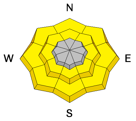
bottom line In the wind zone, at and above treeline, the avalanche danger is HIGH today. Dangerous, human triggered and natural avalanches are VERY LIKELY on steep, wind drifted slopes, especially those facing the north half of the compass, and particularly those with an easterly component to their aspect. Once triggered, today's avalanches have the potential to break deep and wide and can get out of hand quickly, resulting in a dangerous avalanche. You'll find a CONSIDERABLE avalanche danger on steep wind drifted slopes at mid elevations and human triggered avalanches are PROBABLE. At lower elevations a MODERATE avalanche danger exists and human triggered slides are POSSIBLE on steep, water soaked slopes. Big, open meadows, with no steep slopes above or adjacent to where you're riding offer LOW avalanche danger.
|
 |
avalanche warning THE FOREST SERVICE UTAH AVALANCHE CENTER IN SALT LAKE CITY HAS CONTINUED THE BACKCOUNTRY AVALANCHE WARNING. * TIMING...THROUGH 6PM WEDNESDAY * AFFECTED AREA...THE MOUNTAINS OF NORTHERN UTAH, TO INCLUDE THE WASATCH RANGE, THE BEAR RIVER RANGE AND THE MOUNTAINS OF SOUTHEAST IDAHO, THE WESTERN UINTAS, AND THE MANTI-SKYLINE PLATEAU. * AVALANCHE DANGER...THE DANGER IS HIGH * REASON/IMPACTS...HEAVY SNOWFALL AND STRONG WINDS, COMBINED WITH AIN ON SNOW AT THE LOWER ELEVATIONS WILL CREATE WIDESPREAD DANGEROUS AVALANCHE CONDITIONS. AVOID BEING ON OR BENEATH STEEP SLOPES. AVALANCHES RELEASING OFF STEEP ROOFS MAY BE DANGEROUS IN THE URBAN AND MOUNTAIN VALLEYS. THIS WARNING DOES NOT APPLY TO SKI AREAS WHERE AVALANCHE HAZARD REDUCTION MEASURES ARE PERFORMED. |
 |
special announcement TONIGHT: The Salt Lake City premier of The Fourth Phase from the creators of The Art of Flight will at Brewvies at 7 pm on Monday, Jan 9 as a fundraiser for the Utah Avalanche Center. For tickets and details click HERE. Tomorrow night: On Tuesday, January 10th in Park City, I'll talk about current avalanche conditions and the state of our snow pack. Click HERE for more details. |
 |
current conditions What a way to run a desert... or something to that effect. The past 24 hours have been a mess and it's balmy with a low elevation rain/snow mix. Currently, temperatures are in the upper 20's to almost 40 degrees at the trailheads. The good news is our upper elevation terrain picked up about 6" of dense heavy glop that would make Seattle proud. The bad news... southwest winds began ramping up around lunchtime yesterday and are currently blasting into the 70's and 80's along the high ridges. In the past 48 hours our five star riding conditions took a turn for the worse and it might be a good day to get your taxes done. But if you are headed into the mountains you can still find patches of soft, settled snow on mid elevation wind sheltered, shady slopes.
Above is a 24 hour timeline of Lofty Lake Peak Real time wind, snow, and temperatures for the Uinta's are found here. Snowpack observations and trip reports are found here. |
 |
recent activity No new avalanche activity to report. A full list of recent Uinta avalanche activity is found here. |
| type | aspect/elevation | characteristics |
|---|

|

|
LIKELIHOOD
 LIKELY
UNLIKELY
SIZE
 LARGE
SMALL
TREND
 INCREASING DANGER
SAME
DECREASING DANGER
|
|
description
A warm, wet, windy system is slamming into our region and it's gonna get pretty dicey the next few days. Due to the strong winds and now snow avaialble to blow around, I suspect drifting is occurring in unusual locations and lower downslope than we normally see. As the storm continues to materialize, avalanches will begin breaking much deeper and wider than you might expect. In addition they'll be packing a punch. It doesn't mean I can't ride... it does mean I'll want to steer clear of steep, wind drifted terrain and be on the look out for and avoid any rounded, fat, pillows of snow, especially if they feel or sound hollow like a drum.
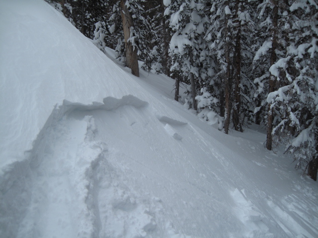
Even without much fresh snow to work with, Ted found shallow wind drifts in Gold Hill, sensitive to his additional weight Saturday. His trip report is found here. |
| type | aspect/elevation | characteristics |
|---|

|

|
LIKELIHOOD
LIKELY
UNLIKELY
SIZE
 LARGE
SMALL
TREND
INCREASING DANGER
SAME
DECREASING DANGER
|
|
description
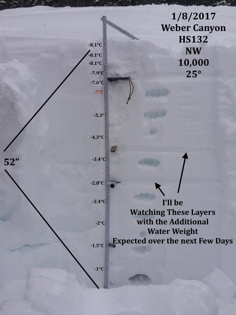
In general, I'm really psyched with our snowpack structure and it's looking very promising. However, we've got a couple of buried weak layers in our pack and this storm is going to stress these fragile crystals and really put 'em to the test. Sure, many slopes are getting comfortable in their own skin, but I think I'll avoid any steep, rocky, upper elevation slope facing the north half of the compass. To me they're guilty until proven otherwise.
|
| type | aspect/elevation | characteristics |
|---|

|
|
LIKELIHOOD
 LIKELY
UNLIKELY
SIZE
 LARGE
SMALL
TREND
 INCREASING DANGER
SAME
DECREASING DANGER
|
|
description
Rain fell on cold snow yesterday and of course, that's never a good scenario. While this problem will be short-lived, be aware of steep, lower elevation slopes and avoid terrain traps like road cuts and gullies where damp, water laden snow can stack up very deeply. |
 |
weather Skies will be mostly cloudy and southwest winds crank into the 40's and 50's with gusts in the 80's along the high ridges. Temperatures cool into the 30's with overnight lows dipping into the teens after midnight. Snow re-develops today ahead of an approaching cold front. Snow becomes less dense late today and tonight as colder air filters into the region and we can expect a foot by Tuesday morning. An active pattern is on tap for this week. |
| general announcements Remember your information can save lives. If you see anything we should know about, please participate in the creation of our own community avalanche advisory by submitting snow and avalanche conditions. You can call me directly at 801-231-2170, email [email protected] The information in this advisory is from the US Forest Service which is solely responsible for its content. This advisory describes general avalanche conditions and local variations always occur. The information in this advisory expires 24 hours after the date and time posted, but will be updated by 7:00 AM on Tuesday January 10th. |