| Please join us at the 23rd annual Black Diamond Fall Fundraiser Party Thursday Sept 15. Tickets are on sale now here, at the Black Diamond store & at REI. Special bonus raffle for online ticket purchasers! |
| Please join us at the 23rd annual Black Diamond Fall Fundraiser Party Thursday Sept 15. Tickets are on sale now here, at the Black Diamond store & at REI. Special bonus raffle for online ticket purchasers! |
| Advisory: Uintas Area Mountains | Issued by Craig Gordon for Tuesday - December 22, 2015 - 3:50am |
|---|


|
bottom line At mid and upper elevations at and above treeline, a HIGH avalanche danger exists on steep, wind drifted terrain facing the north half of the compass. Both natural and human triggered avalanches are very likely, particularly on slopes with an easterly component to their aspect. Any slide triggered today will be deep, dangerous, and quite possibly, unsurvivable. A CONSIDERABLE danger is found at low elevations facing the north half of the compass and human triggered avalanches are likely on steep wind drifted slopes. Low elevation south facing terrain had no weak old snow prior to the big Solstice storm and these slopes offer a LOW avalanche danger.
|
 |
avalanche warning THE FOREST SERVICE UTAH AVALANCHE CENTER IN SALT LAKE CITY HAS ISSUED A BACKCOUNTRY AVALANCHE WARNING. * TIMING...IN EFFECT FROM 3:30 PM MST MONDAY TO 6 AM MST WEDNESDAY * AFFECTED AREA...ALL THE MOUNTAINS OF NORTHERN AND CENTRAL UTAH AND SOUTHEASTERN IDAHO TO INCLUDE THE WASATCH RANGE, THE BEAR RIVER RANGE, THE WESTERN UINTAS AND THE MANTI-SKYLINE PLATEAU. OTHER MOUNTAIN RANGES WILL LIKELY BE AFFECTED AS WELL * AVALANCHE DANGER...THE AVALANCHE DANGER FOR THE WARNING AREA IS HIGH * IMPACTS...HEAVY SNOWFALL COMBINED WITH STRONG WINDS IS CREATING WIDESPREAD AREAS OF UNSTABLE SNOW. BOTH HUMAN TRIGGERED AND NATURAL AVALANCHES ARE LIKELY AND WILL OCCUR IN MANY AREAS. STAY OFF OF AND OUT FROM UNDER SLOPES STEEPER THAN 30 DEGREES. |
 |
special announcement This is the real deal and there's no reason to pull on the dogs tail. Very dangerous avalanche conditions exist and slides can be triggered not only on steep wind drifted slopes, but also low on the slope and from adjacent terrain. Once triggered, today's avalanches will break deep and wide, taking out the entire seasons snowpack. This is the exact type of setup that leads to avalanche accidents that always have a sad, devastating ending. |
 |
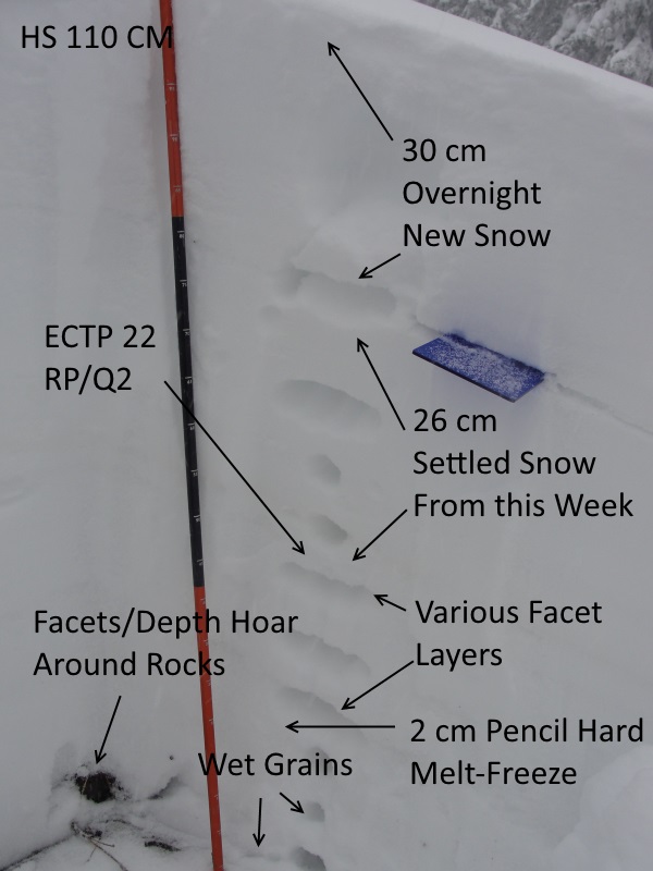
current conditions Wow.... the Uinta's got pounded overnight with 14" of dense, heavy, water laden snow. In addition, southwest winds cranked in the 40's and 50's all day yesterday and haven't subsided this morning. Temperatures are in the mid to upper 20's. Trip reports and observations are found here.
|
 |
recent activity
Michael J was able to collapse low angle slopes yesterday and trigger this slide above while in a safe location along a ridgeline. Recent avalanche observations are found here and a viddy recap of last weeks avalanche cycle is found here See or trigger an avalanche? Shooting cracks? Hear a collapse? It's simple. Go here to fill out an observation. |
| type | aspect/elevation | characteristics |
|---|

|

|
LIKELIHOOD
 LIKELY
UNLIKELY
SIZE
 LARGE
SMALL
TREND
 INCREASING DANGER
SAME
DECREASING DANGER
|
|
description
There's no reason to spend a lot of time spinning creative yarns and using metaphors about how dangerous the avalanche conditions are today. Guess I'll have to use the Rousey/Holm MMA smackdown analogy another time. The fact is.... we've put a ton of heavy, wet, wind driven snow on top of a shaky, weak snowpack. It's kindergarden science (thanks Mark) strong blocks stacked on weak blocks. The result if you trigger a slide today will be devastating. It'll be crazy out there the next couple of days, but it doesn't mean you can't ride. Simply tone it down and stick with low angle terrain, or carve deep trenches in big, open meadows with no steep slopes above our adjacent to where you're rding.
Michael J was in Weber Canyon yesterday and found the snowpack quite reactive. His informative trip report is found here.
|
 |
weather A west-northwest flow remains over the region this morning, producing a round of heavy snow through early afternoon. Temperatures remain mild, in the mid 20's and low 30's. Winds veer to the west and northwest later today and lighter density snow moves into the area. Temperatures dip into the teens overnight and another wave of snow passes by this evening. A break is expected late Wednesday into the day Thursday before another storm brings accumulating snowfall for Christmas.
|
| general announcements Remember your information can save lives. If you see anything we should know about, please participate in the creation of our own community avalanche advisory by submitting snow and avalanche conditions. You can call me directly at 801-231-2170, email [email protected], or email by clicking HERE This is a great time of year to schedule a free avalanche awareness presentation for your group or club. You can contact me at 801-231-2170 or email [email protected]. To register for the first in our series of on-the-snow sled specific classes you can register here. The information in this advisory is from the US Forest Service which is solely responsible for its content. This advisory describes general avalanche conditions and local variations always occur. The information in this advisory expires 24 hours after the date and time posted, but be will be updated by 7:00 AM on Wednesday, December 23rd.
|