25th Annual Black Diamond Fall Fundraising Party
Thursday, September 13; 6:00-10:00 PM; Black Diamond Parking Lot
25th Annual Black Diamond Fall Fundraising Party
Thursday, September 13; 6:00-10:00 PM; Black Diamond Parking Lot
| Advisory: Logan Area Mountains | Issued by Toby Weed for Wednesday - February 1, 2017 - 7:11am |
|---|


|
bottom line Pockets of heightened avalanche conditions exist, with triggered persistent slab, wind slab, and loose wet avalanches possible. Triggered persistent slab avalanches, 2' deep, are possible at mid and lower elevations on slopes with buried surface hoar or facets capping sun-crust. Wind slab avalanches are possible in drifted terrain, as are wet avalanches on steep slopes with moist snow. Evaluate snow and terrain carefully, avoid slopes with poor snow structure, steep drifted terrain, and areas with saturated snow.
|
 |
special announcement Do you buy groceries at Smiths? When you register your Smith’s rewards card with their Community Rewards program, they will donate to the Utah Avalanche Center whenever you make a purchase. It's easy, only takes a minute, and doesn't cost you anything. Details here. |
 |
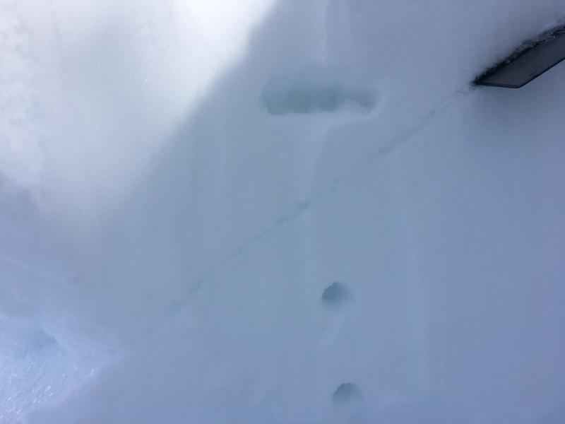
current conditions The 8400' Tony Grove Snotel reports 29 F and 95" of total snow containing 151% of average SWE (Snow Water Equivalent.) It's 23 F at the CSI Logan Peak weather station at 9700', and the wind is blowing from the southwest at 25 mph, with a gusts of 47 mph early this morning. Fine re-crystallized powder still exists on many sheltered, shady slopes in the area, but wind and sun have taken toll. Sustained southwest winds in the past couple days stripped snow off of windward slopes and drifted it into upper elevation deposition zones. Most exposed slopes now sport wind-crust, sastrugi, or stiff wind slabs. South facing and low elevation slopes are sun or warmth affected, and the snow is crusty or saturated. Lots of people got out this weekend and no significant avalanches were reported. The snow is stable in most places, but areas with unstable snow exist. Triggered avalanches, 2' deep, on buried surface hoar are possible on mid elevation slopes. Another triggered avalanche on surface hoar yesterday near Park City, and collapses, cut-bank activity, and snowpit tests locally indicate continuing avalanche potential. Over the weekend, I found poor snow structure with buried surface hoar and weak facets capping a sun-crust in sunnier areas at mid and lower elevations on west and southwest facing slopes in East Wood Camp in the the southern Bear River Range.
Poor snow structure and triggered avalanche potential exist on slopes with buried surface hoar or sugary facets capping a sun-crust. (1/29/17) |
 |
recent activity
|
| type | aspect/elevation | characteristics |
|---|

|

|
LIKELIHOOD
 LIKELY
UNLIKELY
SIZE
 LARGE
SMALL
TREND
 INCREASING DANGER
SAME
DECREASING DANGER
|
description
|
| type | aspect/elevation | characteristics |
|---|

|

|
LIKELIHOOD
LIKELY
UNLIKELY
SIZE
LARGE
SMALL
TREND
INCREASING DANGER
SAME
DECREASING DANGER
|
|
description
Heightened wind slab avalanche conditions exist in drifted upper and mid elevation terrain.
|
| type | aspect/elevation | characteristics |
|---|

|
|
LIKELIHOOD
LIKELY
UNLIKELY
SIZE
LARGE
SMALL
TREND
 INCREASING DANGER
SAME
DECREASING DANGER
|
|
description
Warm temperatures will cause a heightened danger of wet avalanches during the middle of the day in sheltered terrain at mid and low elevations. Cloud cover will probably keep sunny slopes from getting too warm, but if the sun peeks out for a little while, clouds may trap the heat. Green-housing could cause the soft snow on shady slopes to become saturated and prone to wet avalanche activity. |
 |
weather A ridge of high pressure will remain in place across the region through Friday. However a series of weak weather systems will begin to cross the northern portions of the area tonight through the weekend gradually weakening the ridge. It'll be mostly cloudy today, with a high temperature at 8500' of 42 F, west winds 20 to 25 mph and gusts in the mid thirties. Tonight will be mostly cloudy, with a low temperature of 22 F and 15 mph west-southwest winds. Snow is possible tomorrow afternoon (1 to 2 inches), with a high temperature of 32 F and 15 to 20 mph west-southwest winds. 1 to 2 inches of snow is possible Thursday night, with a low temperature of 22 F and 15 mph west wind. |
| general announcements Any time is a great time to practice companion rescue techniques with your partners. Companion Rescue Practice Video If you sign up for AmazonSmile and designate the Utah Avalanche Center as your favorite charity, they will donate a portion of everything you spend to the UAC. It doesn't cost you a penny and we'd really appreciate the help. Discount lift tickets for Beaver Mountain, Snowbasin, Powder Mountain, and the Central Wasatch resorts are donated by the resorts to benefit the Utah Avalanche Center. Details and order information here. Your information can save lives. If you see anything we should know please help us out by submitting snow and avalanche observations. You can call us at 801-524-5304, email by clicking HERE, or include @utavy in your Instagram. In the Logan Area you can reach me at 435-757-7578 We will update this advisory regularly on Monday, Wednesday, Friday, and Saturday mornings by about 7:30. This advisory is from the U.S.D.A. Forest Service, which is solely responsible for its content. This advisory describes general avalanche conditions and local variations always exist. |