| Please join us at the 23rd annual Black Diamond Fall Fundraiser Party Thursday Sept 15. Tickets are on sale now here, at the Black Diamond store & at REI. Special bonus raffle for online ticket purchasers! |
| Please join us at the 23rd annual Black Diamond Fall Fundraiser Party Thursday Sept 15. Tickets are on sale now here, at the Black Diamond store & at REI. Special bonus raffle for online ticket purchasers! |
| Advisory: Logan Area Mountains | Issued by Toby Weed for Tuesday - April 5, 2016 - 7:04am |
|---|


|
bottom line LOW (Level 1): Freezing overnight temperatures, clouds this morning, and northerly winds should keep the saturated snow fairly solid today in the backcountry. Even so, heightened wet avalanche conditions may develop in some steep sheltered terrain as the surface snow softens up again with daytime seasonal and solar warming. Use normal caution and retreat from steep slopes if you start sinking into melt-softened wet snow.
|
 |
current conditions The Tony Grove Snotel at 8400' reports 87 inches of total snow containing 102% of average water for the date. Temperatures dropped overnight and I'm reading 18 degrees at the 9700' CSI Logan Peak weather station, with north winds currently averaging around 20 mph. Looks like a good refreeze of the wet snow surface at least at upper elevations. Most slopes will be crusty this morning and I don't think there's much in the way of powder after the recent warmth, but you might find areas with nice supportable and softening spring snow on sunny upper elevation slopes. Be willing to turn around if the wet snow you are in gets soft and sloppy.
|
 |
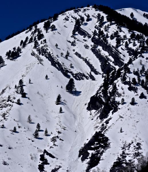
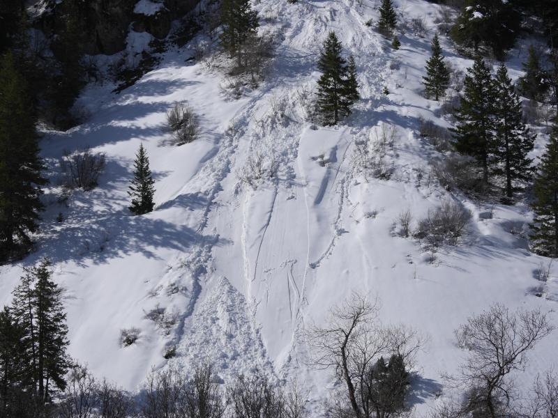
recent activity Natural wet avalanches during the heat of the day and involving late March snow were common across the Logan Zone in the first few days of April.
An example of natural loose wet activity in lower Providence Canyon (4-1-16) ***To view our updated list of backcountry observations and avalanche activity from around Utah, go to our observations page |
| type | aspect/elevation | characteristics |
|---|

|

|
LIKELIHOOD
 LIKELY
UNLIKELY
SIZE
 LARGE
SMALL
TREND
 INCREASING DANGER
SAME
DECREASING DANGER
|
|
description
Moist sluffs entraining melt-saturated surface snow are possible again today, perhaps on sunny sheltered slopes that become softened by solar warming.
|
 |
weather An upper level through will cross the region today bringing cooler and dryer air. Isolated snow showers are possible before noon. Expect mostly sunny conditions this afternoon, with 9000' high temperatures around 36... It'll be breezy at upper elevations, with west northwest winds in the 20 to 25 mph range and gusts nearing 40 mph on the ridges. It'll be mostly clear tonight with a low temperature around 24 degrees and moderating west winds. Looks like a nice spring day in the mountains tomorrow, with sunny skies, a high temperature around 46 degrees and moderate westerly winds.
|
| general announcements The National Avalanche Center recently completed an animated tutorial on the North American Avalanche Danger Scale. HERE Please submit snow and avalanche observations from your ventures in the backcountry HERE. You can call us at 801-524-5304 or email HERE, or include #utavy in your Instagram or Tweet us @UAClogan. To report avalanche activity in the Logan Area or to contact the local avalanche forecaster call me, Toby, at 435-757-7578. We'll update this advisory throughout the season on Monday, Wednesday, Friday, and Saturday mornings by about 7:30 This advisory is produced by the U.S.D.A. Forest Service, which is solely responsible for its content. It describes only general avalanche conditions and local variations always exist.
|