| Please join us at the 23rd annual Black Diamond Fall Fundraiser Party Thursday Sept 15. Tickets are on sale now here, at the Black Diamond store & at REI. Special bonus raffle for online ticket purchasers! |
| Please join us at the 23rd annual Black Diamond Fall Fundraiser Party Thursday Sept 15. Tickets are on sale now here, at the Black Diamond store & at REI. Special bonus raffle for online ticket purchasers! |
| Advisory: Logan Area Mountains | Issued by Toby Weed for Monday - February 1, 2016 - 7:00am |
|---|

|
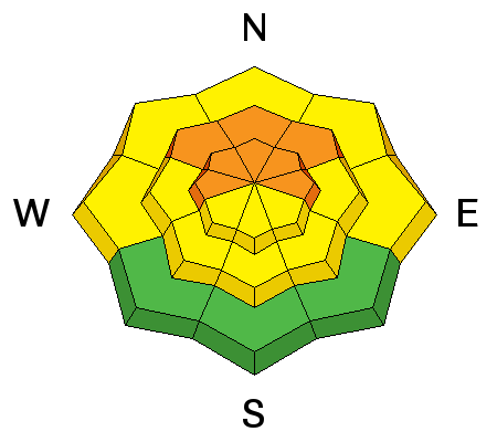
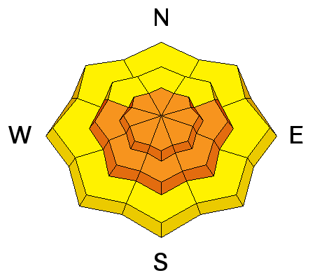
bottom line CONSIDERABLE (level 3): Dangerous avalanche conditions exist on drifted slopes in the backcountry. Careful snowpack evaluation, cautious routefinding, and conservative decision-making will be essential today. You are likely to trigger wind slab avalanches on drifted upper elevation slopes, and large and dangerous triggered avalanches remain possible on slopes with poor snow structure steeper than about 30 degrees.
|
 |
current conditions The temperature is 11 degrees at the 8400' Tony Grove Snotel. There's 77 inches of total snow, containing 108% of average water content for the date. The 9700' CSI Logan Peak weather station reports 3 degrees and the wind sensor appears rimed. The UDOT Hwy 89 summit weather station reports 6 degrees and light to moderate wind from the east overnight, veering from the north with speeds in the single digits this morning.
|
 |
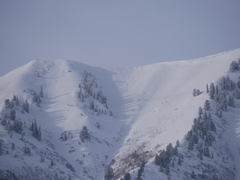
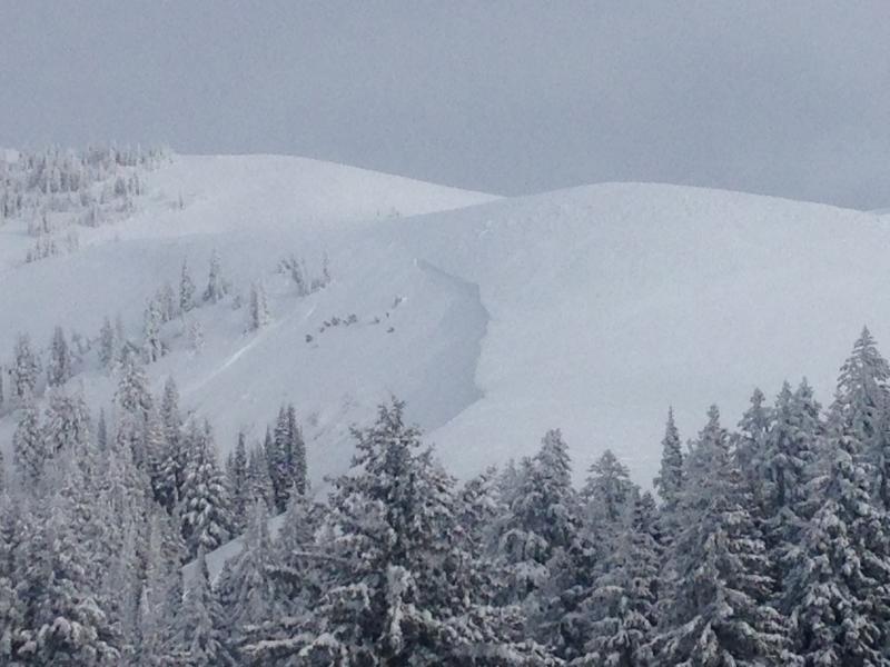
recent activity Looks like a fairly widespread natural avalanche cycle over the weekend, with numerous large and long running avalanches visible in the generally east facing avalanche paths of the Wellsville Range above the towns of Mendon and Wellsville, and south, above Hwy 89/91 (Sardine) A hiker on snow-shoes triggered and may have been caught in a loose (wet?) avalanche at the mouth of Logan Dry Canyon Saturday. There were several (apparently manageable) human triggered avalanches last week. These on north through east facing upper and mid elevation slopes were around a foot deep and up to about 50' wide. A video posted on Facebook from a large sled triggered avalanche (1-19-16) in Christmas Tree Bowl is .....HERE ***To view our updated list of backcountry observations and avalanche activity from around Utah, go to our observations page
|
| type | aspect/elevation | characteristics |
|---|

|
|
LIKELIHOOD
 LIKELY
UNLIKELY
SIZE
 LARGE
SMALL
TREND
 INCREASING DANGER
SAME
DECREASING DANGER
|
|
description
Wind slab avalanches including drifted fresh snow and failing within the storm snow or on preexisting weak surface snow are likely in steep wind exposed terrain today.
|
| type | aspect/elevation | characteristics |
|---|

|
|
LIKELIHOOD
 LIKELY
UNLIKELY
SIZE
 LARGE
SMALL
TREND
 INCREASING DANGER
SAME
DECREASING DANGER
|
|
description
Heavy snow over the weekend overloaded a complex snowpack, with existing buried persistent weak layers in some areas and still weak basal layer depth hoar in others.
***Pay close attention to signs of unstable snow like recent avalanches, whumpfing, and shooting cracks, and be willing to reevaluate your plans. In these conditions you could trigger avalanches remotely, from a distance or worse, from below!
|
| type | aspect/elevation | characteristics |
|---|

|
|
LIKELIHOOD
LIKELY
UNLIKELY
SIZE
LARGE
SMALL
TREND
 INCREASING DANGER
SAME
DECREASING DANGER
|
|
description
In some areas the weekend snow fell on and preserved weak surface snow consisting of small sugary or faceted grains or feathery frost crystals called surface hoar. On sunnier slopes, weak snow formed at the interface of a warm sun-crust from last week and the colder new snow from Saturday, and yesterday my snowpit tests showed fairly easy and consistent failures with propagation. In any of these areas where weak snow exists, persistent slab avalanches are possible. You'll have to dig into the snow to find these weaknesses, but red flags of instability like cracking and whumpfing could also be present... |
 |
weather A significant storm is moving through southern and central Utah, but it'll stay mostly south of the Logan Zone. Snow is likely and it'll be blustery and cloudy today in the mountains, with a steady temperature around 13 degrees, and northeast winds in the 20 mph hour range with higher gusts along the ridges. An inch or so of accumulation is possible. Snow showers are likely tonight, with low temperatures in the single digits and north winds. Another inch or so of accumulation is possible. Looks like it'll be partly sunny tomorrow, with a chance of snow showers, north-northwest winds, and high temperatures at 8500' around 13 degrees. A cold northerly flow will persist through the middle of the week. |
| general announcements Please submit snow and avalanche observations from your ventures in the backcountry HERE. You can call us at 801-524-5304 or email HERE, or include #utavy in your Instagram or Tweet us @UAClogan. To report avalanche activity in the Logan Area or to contact the local avalanche forecaster call me, Toby, at 435-757-7578. I'll update this advisory throughout the season on Monday, Wednesday, Friday, and Saturday mornings by about 7:30 This advisory is produced by the U.S.D.A. Forest Service, which is solely responsible for its content. It describes only general avalanche conditions and local variations always exist. |