| Please join us at the 23rd annual Black Diamond Fall Fundraiser Party Thursday Sept 15. Tickets are on sale now here, at the Black Diamond store & at REI. Special bonus raffle for online ticket purchasers! |
| Please join us at the 23rd annual Black Diamond Fall Fundraiser Party Thursday Sept 15. Tickets are on sale now here, at the Black Diamond store & at REI. Special bonus raffle for online ticket purchasers! |
| Advisory: Abajo Area Mountains | Issued by Eric Trenbeath for Saturday - February 20, 2016 - 6:46am |
|---|


|
bottom line The avalanche danger is generally LOW on most slopes in the Abajo Mountains. An isolated, or MODERATE danger exists on very steep, upper elevation slopes with a N-NE-E aspect where it may still be possible to trigger an avalanche down to weak, sugary, faceted snow on the ground. The danger for wet slide activity will increase to MODERATE on steep, sun exposed slopes as the day heats up.
|
 |
current conditions
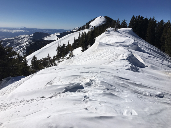
Skies are clear this morning and ridge top winds are in the 10-20 mph range from the southwest. It's a mixed bag of spring like conditions out there and wind, sun, and warm temperatures have taken their toll on the snow surface in most areas.Snow cover ranges from 3-4' deep in sheltered locations, with some sun and wind exposed slopes showing bare ground. It's currently 25 degrees on Abajo Peak and 38 at Buckboard Flat.
Winds have hammered the snow from all directions. Note cornices formed on both sides of the ridge. Winds, temperature and humidity on Abajo Peak. Snow totals at Buckboard Flat. Snow totals at Camp Jackson.
|
 |
recent activity
|
| type | aspect/elevation | characteristics |
|---|

|

|
LIKELIHOOD
 LIKELY
UNLIKELY
SIZE
 LARGE
SMALL
TREND
 INCREASING DANGER
SAME
DECREASING DANGER
|
|
description
A few isolated areas remain where a strong slab sits on top of weak, sugary faceted snow near the ground. The scenario is low probability but high consequence. Areas where you are most likely to encounter this problem are on upper elevation slopes steeper than about 40 degrees that have N-NE-E aspect.
|
| type | aspect/elevation | characteristics |
|---|

|

|
LIKELIHOOD
LIKELY
UNLIKELY
SIZE
 LARGE
SMALL
TREND
 INCREASING DANGER
SAME
DECREASING DANGER
|
|
description
As the sun heats up the snow surface, be alert to an increasing danger for loose, wet avalanches on steep, sun exposed slopes. |
 |
weather No new snow on the horizon for us. Look for mostly sunny skies through Monday. By Monday night, a storm system tracking through to the north will bring us clouds and blustery winds, with a prolonged period of dry and clear weather returning by Wednesday Today Sunny, with a high near 39. West southwest wind 10 to 15 mph. Tonight Mostly clear, with a low around 27. Northwest wind 10 to 15 mph. Sunday Sunny, with a high near 38. Breezy, with a west northwest wind 15 to 20 mph. Sunday Night Mostly clear, with a low around 25. Blustery, with a north wind 15 to 20 mph, with gusts as high as 30 mph. Monday Mostly sunny, with a high near 35. Breezy, with a south southwest wind 20 to 25 mph becoming north northwest in the morning. Winds could gust as high as 35 mph. Monday Night A 10 percent chance of snow. Mostly cloudy, with a low around 22. Blustery. Tuesday A 20 percent chance of snow. Mostly sunny, with a high near 28. Blustery. |
| general announcements Let me know what you are seeing down there by posting an observation here. You can also call me on my cell phone at 801-647-8896 To receive this advisory by email go here. This information does not apply to developed ski areas or highways where avalanche control is normally done. This advisory is from the U.S.D.A. Forest Service, which is solely responsible for its content. This advisory describes general avalanche conditions and local variations always exist. |