| Please join us at the 23rd annual Black Diamond Fall Fundraiser Party Thursday Sept 15. Tickets are on sale now here, at the Black Diamond store & at REI. Special bonus raffle for online ticket purchasers! |
| Please join us at the 23rd annual Black Diamond Fall Fundraiser Party Thursday Sept 15. Tickets are on sale now here, at the Black Diamond store & at REI. Special bonus raffle for online ticket purchasers! |
| Advisory: Abajo Area Mountains | Issued by Eric Trenbeath for Saturday - January 2, 2016 - 7:37am |
|---|

|
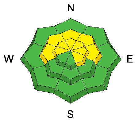
bottom line The avalanche danger is MODERATE today on slopes steeper than 35 degrees that face W-N-E. We are currently in a low probability - high consequence phase for triggering a dangerous avalanche in these areas. Stick to slopes less steep than 35 degrees or choose a southerly facing aspect for safer riding conditions today.
|
 |
special announcement This advisory will provide detailed snow, avalanche and mountain weather information on weekends. During the week, general information and an overall danger rating will be provided. |
 |
current conditions The snowpack is still relatively thin but there is enough snow to ride around on. Base depth varies from around 2' at lower elevations to around 3' up high. Winds have affected the snow surface in exposed areas, but settled powder remains in sheltered locations. East-southeast winds yesteraday averaged 20-25 mph along ridge tops. This morning they have backed off slightly and shifted to the southwest. It's currently 16 degrees on Abajo Peak. Winds, temperature and humidity on Abajo Peak. Snow totals at Buckboard Flat.
|
 |
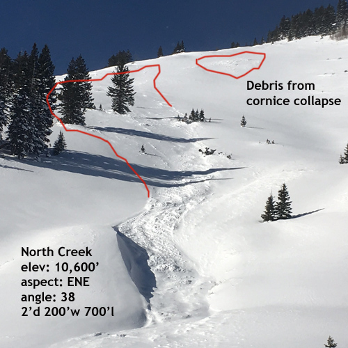
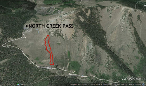
recent activity In my travels yesterday I ran into this avalanche in North Creek that probably ran during the wind event of Dec 26, though it could also could have been sled triggered due to it's proximity to a popular hill climbing area. Winds and time erased much of the evidence. If anyone has any information, please send me an email to [email protected].
|
| type | aspect/elevation | characteristics |
|---|

|
|
LIKELIHOOD
 LIKELY
UNLIKELY
SIZE
 LARGE
SMALL
TREND
 INCREASING DANGER
SAME
DECREASING DANGER
|
|
description
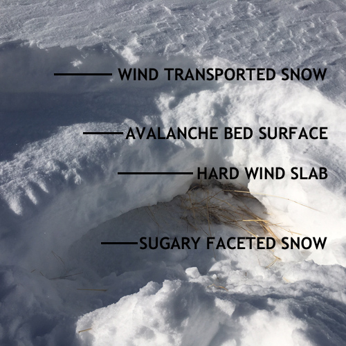
The snowpack is shallow and weak and in many cases, old hard wind slabs are sitting on top of the underlying weak, sugary, faceted snow. The slide in North Creek ran down to the surface of an old hard wind slab, but in some cases it may be possible to trigger an avalanche more than 3' deep to the ground. Suspect slopes steeper than 35 degrees that face W-N-E. When more snow comes, additional stress will be added to these buried weak layers creating a more dangerous situation.
I climbed up to where the slide released and dug into the snow. The newly deposited, wind transported snow is sitting on top of the bed surface, which is the surface the avalanche ran on. The bed surface is the top of an old, hard wind slab which is sitting on top of very weak, sugary, faceted snow. It may still be possible to trigger an avalanche that will take out this buried wind slab and release to the ground.
|
| type | aspect/elevation | characteristics |
|---|

|
|
LIKELIHOOD
LIKELY
UNLIKELY
SIZE
 LARGE
SMALL
TREND
 INCREASING DANGER
SAME
DECREASING DANGER
|
|
description
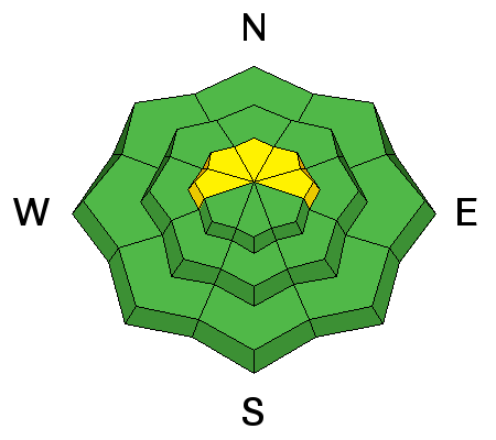
Moderate southeast winds yesterday were moving snow around, and I observed shallow wind slabs forming on the lee sides of ridge crests and terrain features in upper elevation, wind exposed terrain. These shouldn't pose much of a problem for riders but there is a chance that one triggered could step down into deeper layers causing a deeper and more dangerous persistent slab avalanche. Look for smooth rounded pillows of recently deposited, wind drifted snow, and look for cracking in the snow surface. |
 |
weather A short lived ridge will build over the region for the next 48 hours ushering in slightly warmer temperatures. By Monday, the first in a series of troughs moves into the area bringing yet another week of moist, unstable weather with the first shot at significant snow coming on Wednesday. Today Partly sunny, with a high near 21. South southwest wind around 10 mph. Tonight Mostly cloudy, with a low around 13. South wind around 10 mph. Sunday Mostly cloudy, with a high near 27. South southwest wind 10 to 15 mph. Sunday Night Mostly cloudy, with a low around 15. South southwest wind around 15 mph becoming southeast in the evening. Monday A 20 percent chance of snow. Mostly cloudy, with a high near 21. South wind around 15 mph. |
| general announcements This advisory is from the U.S.D.A. Forest Service, which is solely responsible for its content. This advisory describes general avalanche conditions and local variations always exist. |