25th Annual Black Diamond Fall Fundraising Party
Thursday, September 13; 6:00-10:00 PM; Black Diamond Parking Lot
25th Annual Black Diamond Fall Fundraising Party
Thursday, September 13; 6:00-10:00 PM; Black Diamond Parking Lot
| Advisory: Uintas Area Mountains | Issued by Craig Gordon for Sunday - April 1, 2018 - 4:38am |
|---|

|
bottom line The avalanche danger increases to MODERATE and human triggered avalanches are possible on steep, sun exposed slopes as temperatures rise and strong sun bakes the snow surface. In addition, there's an isolated, or MODERATE danger of triggering a deep, dangerous dry snow avalanche in steep, rocky terrain with a thin, weak snowpack.
|
 |
special announcement Next Sunday April 8th will be the last of the regularly scheduled advisories for the western Uinta Mountains. |
 |
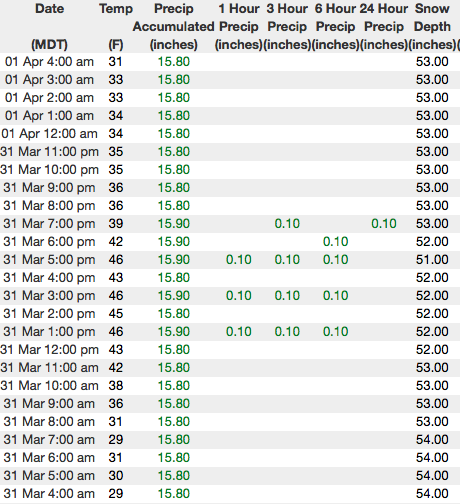
current conditions Happy Easter! A weak cold front slid through the region overnight and temperatures are dipping into the high 20's and low 30's this morning. In addition, clearing skies reveal a beautiful moon. Along the high ridges, west and southwest winds blow 35-50 mph. Riding and turning conditions are aspect dependant. Sunny slopes offer smooth, suportable, corn-like conditions that soften with strong springtime sun. Whilst on the other half of the compass, a few patches of soft shallow snow are found on upper elevation wind sheltered, shady slopes.
Above are 24 hour temperatures and snow depth near Trial Lake along with winds and temperatures from Windy Peak. More remote Uinta weather stations are found here A great body of recent trip reports, observations, and snow data here. |
 |
recent activity No significant avalanche activity to report from yesterday. A full list of recent avalanches is found here. |
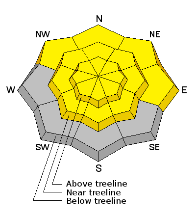
| type | aspect/elevation | characteristics |
|---|

|
|
LIKELIHOOD
 LIKELY
UNLIKELY
SIZE
 LARGE
SMALL
TREND
 INCREASING DANGER
SAME
DECREASING DANGER
|
|
description
Strong sunshine will bake all steep, sun exposed slopes at all elevations. Winds may temper some of the heating, but that's merely a superficial cooling and the snowpack is still taking on heat. So... if the snow you're riding on becomes damp, manky, or the bottom starts falling out, simply change aspect and head to a cooler slope which isn't getting baked. As the day wares on and temperatures soar, you'll want to get off of and out from under steep, sun-exposed slopes. |
| type | aspect/elevation | characteristics |
|---|

|
|
LIKELIHOOD
LIKELY
UNLIKELY
SIZE
 LARGE
SMALL
TREND
INCREASING DANGER
SAME
DECREASING DANGER
|
|
description
We haven't heard of any avalanche activity breaking to deeply buried weak layers since last Saturday and that's good news. Of course, last weekends cold snap helped weld the snowpack in place and where the pack is deep, it's happy in its own skin. For the most part, I think these instabilities have gone dormant for the moment. However, I'm not ready to let my guard down where the pack has remained thin and weak all year. Prime suspects include steep, rocky, mid and upper elevation terrain facing the north half of the compass, along with slopes that already avalanched this season. |
 |
weather
Expect mostly sunny skies this morning with high temperatures climbing into the 40's. West and southwest winds blow in the 50's along the high peaks. A quick hitting storm for Monday has some promise to deliver a shallow coat of white paint. |
| general announcements The information in this advisory expires 24 hours after the date and time posted, but will be updated by 7:00 AM Monday April 2nd, 2018. If you're getting out and about, please let me know what you're seeing especially if you see or trigger and avalanche. I can be reached at [email protected] or 801-231-2170 It's also a good time to set up one of our very popular avalanche awareness classes. Reach out to me and I'll make it happen. This information does not apply to developed ski areas or highways where avalanche control is normally done. This advisory is from the U.S.D.A. Forest Service, which is solely responsible for its content. This advisory describes general avalanche conditions and local variations always occur. |