25th Annual Black Diamond Fall Fundraising Party
Thursday, September 13; 6:00-10:00 PM; Black Diamond Parking Lot
25th Annual Black Diamond Fall Fundraising Party
Thursday, September 13; 6:00-10:00 PM; Black Diamond Parking Lot
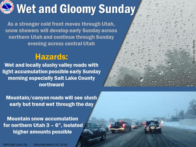
| Advisory: Uintas Area Mountains | Issued by Craig Gordon for Sunday - March 25, 2018 - 4:06am |
|---|

|
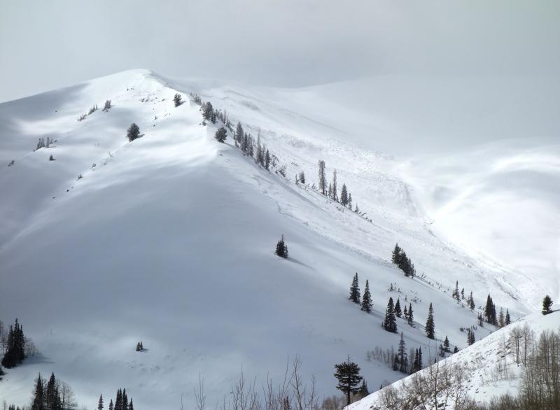
bottom line HEADS UP- MAKE NO MISTAKE... THE AVALANCHE DANGER IS OUT OF THE ORDINARY FOR THIS LATE IN THE SEASON. BREAKING DEEP AND WIDE AND GENERATING HUGE AMOUNTS OF BODY BREAKING DEBRIS, THESE ARE THE TYPE OF AVALANCHES THAT KILL MOST SLEDDERS. A CONSIDERABLE avalanche danger exists in upper elevation terrain, particularly in the wind zone, above treeline. Human triggered dry snow avalanches are LIKELY on all steep wind drifted slopes, especially those facing the north half of the compass, and particularly those with an easterly component to their aspect. At mid elevations, the avalanche danger is MODERATE. Human triggered avalanches are POSSIBLE on steep wind drifted slopes. LOW avalanche danger is found on most south facing terrain and wind sheltered slopes.
|
 |
special announcement We couldn't get out on the snow without the great support from Polaris, Ski Doo, and Arctic Cat as well as KTM and Timbersled. Our local dealers make it happen. Tri-City Performance, Weller Recreation, Northstar's Ultimate Outdoors, Big Pine and Morgan Valley Polaris. We use these machines to monitor the snowpack across the state of Utah. We also use these machines to teach life-saving classes. |
 |
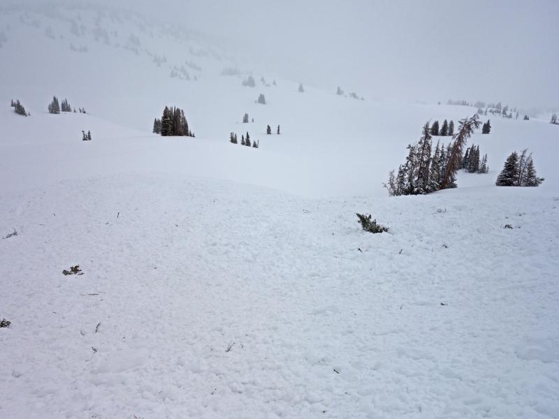
current conditions Snow showers yesterday afternoon brushed the mountains with a fresh coat of white paint and delivered a couple inches of light density snow. Skies are clear this morning and temperatures in the mid teens. Along the high peaks, southerly winds are blowing 40-60 mph. There's some soft, creamy snow out there in wind sheltered terrain, but by far, most slopes offer dust on a mostly supportable crust
Above are 24 hour temperatures and snow depth near Trial Lake along with winds and temperatures from Windy Peak. More remote Uinta weather stations are found here A great body of recent trip reports, observations, and snow data here. |
 |
recent activity
Yesterday on Double Hill, a man riding with his family triggered a wind slab which then pulled out a deeper avalanche that broke to the ground. He was able to get off the moving piece of snow, but the debris ran farther than could have been imagined, coming within 5 feet of where his son was parked. A very close call indeed and this was a bullet dodged that fortunately, had a happy ending.
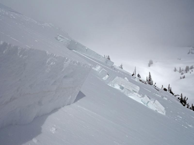
Friday in Upper Moffit Basin, Dave and Jason triggered this, tree snapping monster. I'll let them describe- "Large slide triggered by kicking a large cornice. Cornice triggered a wind slab when it hit the slope below, which then triggered a persistent slab in an area that had previously slide. Slide then propagated out across the slope. Total width ended up being approximately 800 feet wide, with an average crown depth of 4 feet. Ran approximately 500 vertical, taking out several trees on the way. This is an area that had shown a relatively strong, but highly variable snowpack. Up to this point, there has not been a connected slab. However, warming and wind loading created a more connected slab." More details along with a full list of recent avalanches is found here. |
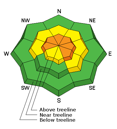
| type | aspect/elevation | characteristics |
|---|

|
|
LIKELIHOOD
 LIKELY
UNLIKELY
SIZE
 LARGE
SMALL
TREND
 INCREASING DANGER
SAME
DECREASING DANGER
|
|
description
Southerly winds have been cranking for the past three days and the most obvious, in your face, avalanche problem today are newly formed slabs. Found mostly on the leeward side of upper elevation ridges, there's also cross-loaded pockets around terrain features like chutes and gullies. In any case, today you'll want to look for and avoid fat, rounded pieces of snow, especially if they sound and feel hollow like a drum. Todays wind slabs are gonna be connected and once triggered have the potential to break deeper and wider than you might expect. |
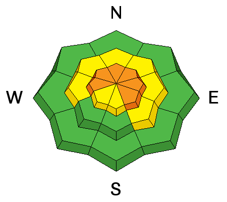
| type | aspect/elevation | characteristics |
|---|

|

|
LIKELIHOOD
LIKELY
UNLIKELY
SIZE
 LARGE
SMALL
TREND
 INCREASING DANGER
SAME
DECREASING DANGER
|
|
description
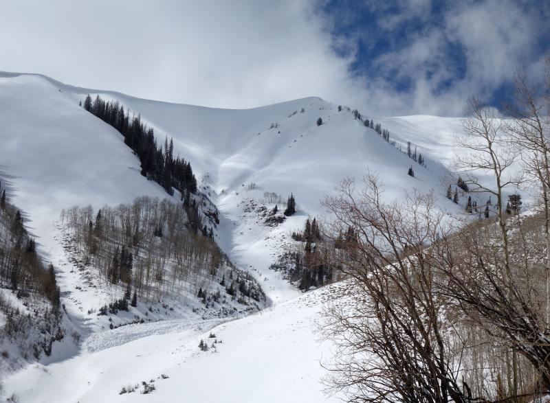
Deep slabs... they're tricky, they're dangerous, they're unpredictable, and now this notoriously deceptive avalanche dragon has come alive on the eastern front. Here's what I know about this type of avalanche problem- Our usual observations regarding snow stability often give us false stability or green light feedback. That means tracks on the slope, cornice drops, or slope cuts are unreliable methods of testing the slope. In fact, this strong, cohesive slab often allows us to get well out onto the slope before it fails and now the snow is breaking to the ground taking out the entire seasons snowpack. These avalanches are killers and as we've seen in the past few days, recently triggered slides are stacking up huge piles of body breaking debris. So how do you manage an unmanageable avalanche problem? Well... we simply avoid it. Steep, mid and upper elevation terrain facing the north half of the compass are prime suspects as are slopes that already avalanched this season. So here's the exit strategy... if you're looking for soft snow and safe riding, simply tone down your slope angles and avoid terrain with steep slopes hanging above you.
The natural slide in the images above is similar to what Dave and Jason triggered Friday morning. This extremely connected piece of snow broke to the dirt early Friday morning and stacked up a huge piles of body snapping debris... unsurviveable if you were on the receiving end. |
 |
weather
The image above looks pretty uninspiring. Snow develops by mid morning and continues through the day with 2"-4" stacking up. South and southwest winds blow in the 50's this morning, before decreasing by midday. High temperatures climb into the mid 20's with overnight lows dipping into the low teens. Snow showers linger into Monday with high pressure building for midweek. |
| general announcements The information in this advisory expires 24 hours after the date and time posted, but will be updated by 7:00 AM Monday March 26th, 2018. If you're getting out and about, please let me know what you're seeing especially if you see or trigger and avalanche. I can be reached at [email protected] or 801-231-2170 It's also a good time to set up one of our very popular avalanche awareness classes. Reach out to me and I'll make it happen. This information does not apply to developed ski areas or highways where avalanche control is normally done. This advisory is from the U.S.D.A. Forest Service, which is solely responsible for its content. This advisory describes general avalanche conditions and local variations always occur. |