25th Annual Black Diamond Fall Fundraising Party
Thursday, September 13; 6:00-10:00 PM; Black Diamond Parking Lot
25th Annual Black Diamond Fall Fundraising Party
Thursday, September 13; 6:00-10:00 PM; Black Diamond Parking Lot
| Advisory: Uintas Area Mountains | Issued by Craig Gordon for Thursday - March 15, 2018 - 3:03am |
|---|

|
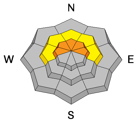
bottom line In upper elevation terrain, especially in the wind zone at and above treeline, the avalanche danger is CONSIDERABLE. Human triggered avalanches are LIKELY on steep wind drifted slopes facing the north half of the compass, particularly those with an easterly component to their aspect. An avalanche triggered today can quickly get out of hand if it breaks into weak layers of snow, now buried deeper in our snowpack. MODERATE avalanche danger exists at mid elevations and human triggered avalanches are possible on steep slopes with recent deposits of wind drifted snow. Lose some elevation or switch aspect and you'll find LOW avalanche danger on lower elevation, wind sheltered terrain and on most slopes facing the south half of the compass.
|
 |
special announcement We couldn't get out on the snow without the great support from Polaris, Ski Doo, and Arctic Cat as well as KTM and Timbersled. Our local dealers make it happen. Tri-City Performance, Weller Recreation, Northstar's Ultimate Outdoors, Big Pine and Morgan Valley Polaris. We use these machines to monitor the snowpack across the state of Utah. We also use these machines to teach life-saving classes. |
 |
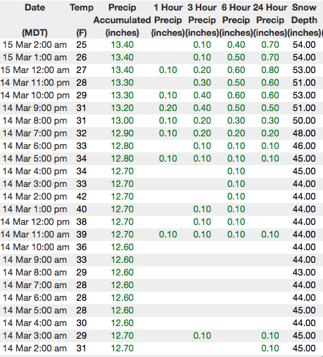
current conditions Last nights storm rolled through the valley like a cross-fire hurricane... delivering a healthy dose of rain, lightening, and yes... even thunder snow! Trial Lake was the big winner with nearly 10" of dense, spongy snow stacking up. Elsewhere across the range storm totals are pretty uniform and register in the 6"-8" range. Southerly winds peaked into the 60's last night right around 8:00 but have decreased and are currently blowing 25-35 mph along the high ridges. Temperatures have fallen into the teens and low 20's. Riding and turning conditions are a complete 180 from yesterday and mid elevation wind sheltered slopes offer soft, surfy snow.
Above are 24 hour temperatures and snow depth near Trial Lake along with winds and temperatures from Windy Peak. More remote Uinta weather stations are found here A great body of recent trip reports, observations, and snow data here.
|
 |
recent activity No new avalanche activity to report A list of recent avalanches is found here. |
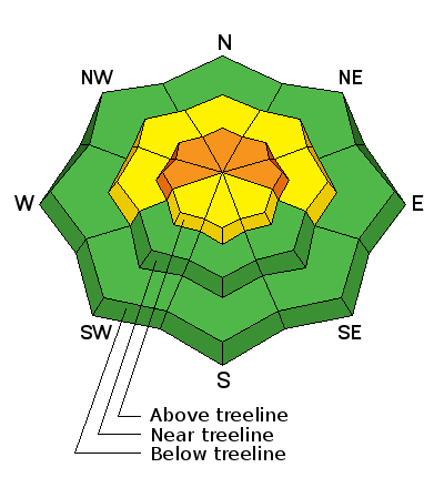
| type | aspect/elevation | characteristics |
|---|

|
|
LIKELIHOOD
 LIKELY
UNLIKELY
SIZE
 LARGE
SMALL
TREND
 INCREASING DANGER
SAME
DECREASING DANGER
|
|
description
Winds finally have some fresh snow to work with this morning and they're forming dense drifts along the leeward side of mid and upper elevation ridges. I think today's drifts have the potential to break a bit deeper and wider than you might expect. However, it's an easy problem to avoid. Simply lose some elevation and steer clear of fat looking, rounded pieces of snow especially if they feel or sound hollow like a drum. |
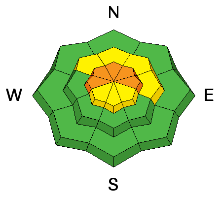
| type | aspect/elevation | characteristics |
|---|

|
|
LIKELIHOOD
 LIKELY
UNLIKELY
SIZE
 LARGE
SMALL
TREND
 INCREASING DANGER
SAME
DECREASING DANGER
|
|
description
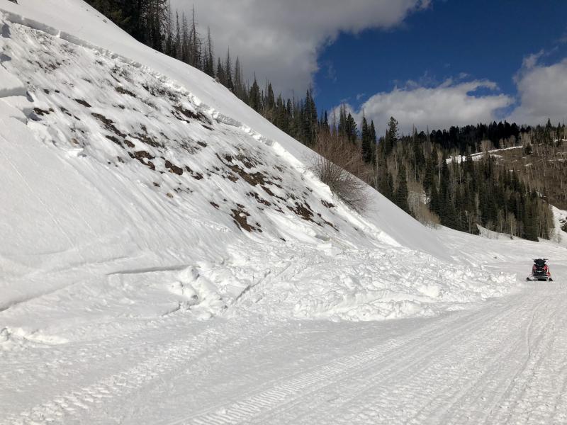
A trickier and more deceptive avalanche problem is our on going relationship with our problem child.... the persitent slab and the buried weaknesses in the mid and lower portions of the snowpack. Persitent slabs are complicated because not every slope is gonna be reactive to our additional weight. This is the kind of snowpack setup that allows us to put tracks on some slopes and feel good about stability, while other slopes break above us. When unpredictable and unmanageable avalanche conditions exist, we avoid where they live. Steep, mid and upper elevation terrain facing the north half of the compass are prime suspects as are slopes that already avalanched this season. So here's your exit strategy... if you're looking for soft snow and safe riding, simply tone down your slope angles and avoid terrian with steep slopes hanging above you.
Breaking to weak layers of snow in the midpack or near the ground, the image above is the type of avalanche dragon we're dealing with today. |
 |
weather A pacific trough continues to bring snow showers through this evening with an additional 2"-4" stacking up. West and southwest winds blow in the 20's and 30's with an occasional gust in the 40's along the high peaks. High temperatures climb into the upper 20's with overnight lows in the teens. Isolated thunderstorms are possible this afternoon. A break in snowfall is expected late tonight through Friday, before another system arrives for the weekend. |
| general announcements The information in this advisory expires 24 hours after the date and time posted, but will be updated by 7:00 AM Friday March 16th, 2018. If you're getting out and about, please let me know what you're seeing especially if you see or trigger and avalanche. I can be reached at [email protected] or 801-231-2170 It's also a good time to set up one of our very popular avalanche awareness classes. Reach out to me and I'll make it happen. This information does not apply to developed ski areas or highways where avalanche control is normally done. This advisory is from the U.S.D.A. Forest Service, which is solely responsible for its content. This advisory describes general avalanche conditions and local variations always occur. |