25th Annual Black Diamond Fall Fundraising Party
Thursday, September 13; 6:00-10:00 PM; Black Diamond Parking Lot
25th Annual Black Diamond Fall Fundraising Party
Thursday, September 13; 6:00-10:00 PM; Black Diamond Parking Lot
| Advisory: Uintas Area Mountains | Issued by Craig Gordon for Thursday - February 22, 2018 - 3:03am |
|---|

|
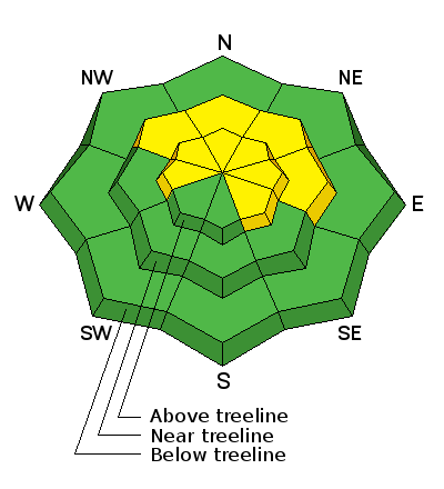
bottom line Heads up- the avalanche danger might be slightly more pronounced from about Trial Lake to Strawberry. In mid and upper elevation terrain, especially in the wind zone at and above treeline, the avalanche danger is MODERATE. Human triggered avalanches are possible on steep wind drifted slopes, facing the north half of the compass, particularly those with an easterly component to their aspect. An avalanche triggered today can quickly get out of hand if it breaks into weak layers of snow, now buried deeper in our snowpack. Lose some elevation or switch aspect and you'll find LOW avalanche danger at lower elevation wind sheltered terrain and on most slopes facing the south half of the compass.
|
 |
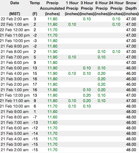
current conditions Skies are partly cloudy and temperatures near zero... about 10 degrees warmer than yesterday morning at this time. However, with southerly winds blowing 10-20 mph along the high ridges, it's not exactly balmy and when you factor in wind chill, it's right around -20 degrees. Sunday's storm snow has settled somewhat and riding conditions remain excellent, especially on wind sheltered, shady slopes. Above are 24 hour temperatures and snow depth from upper Trial Lake along with winds and temperatures from Windy Peak. More remote Uinta weather stations are found here You can find a great body of recent trip reports, observations, and snow data here.
|
 |
recent activity
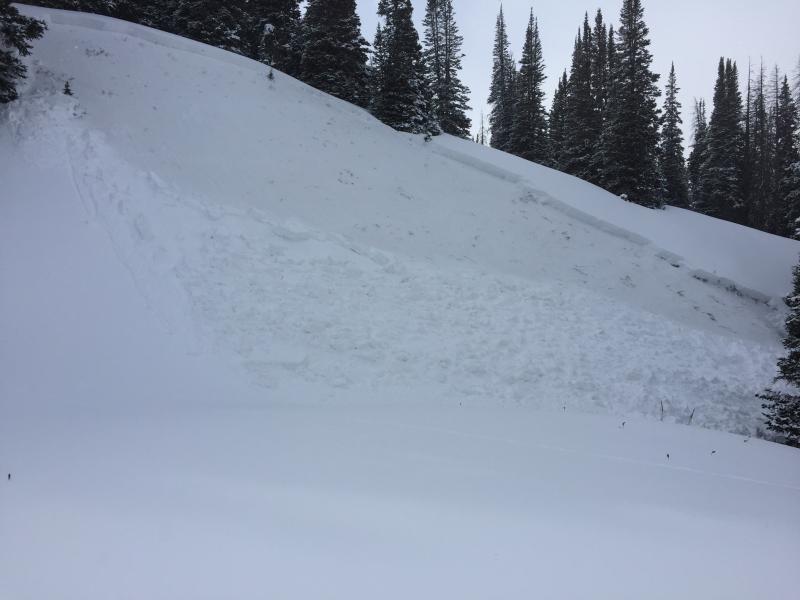
Michael J was near Duke Bowl yesterday and triggered this slab on a steep, northerly facing slope. Breaking 16" deep, this pocket failed on facets below last weeks storm snow. More on his travels here. |
| type | aspect/elevation | characteristics |
|---|

|

|
LIKELIHOOD
 LIKELY
UNLIKELY
SIZE
 LARGE
SMALL
TREND
 INCREASING DANGER
SAME
DECREASING DANGER
|
|
description
Where the pack is deep, it's comfortable in its own skin and can take a good thump. However, where the pack is shallow, (like the slide above near Currant Creek Pass) the jury is still out. Suspect areas include terrain that has already avalanched this year along with a vast majority of steep, shady slopes on the south half of the range... from about Trial Lake through Strawberry. As always in this case, the best offense is a good defense. Simply avoid steep, rocky, wind drifted slopes, especially if they've got a "trapdoor" or punchy feeling. |
| type | aspect/elevation | characteristics |
|---|

|

|
LIKELIHOOD
LIKELY
UNLIKELY
SIZE
 LARGE
SMALL
TREND
INCREASING DANGER
SAME
DECREASING DANGER
|
|
description
Today's drifts may be a little more stubborn, but could none-the-less surprise you on steep leeward slopes or near the entrances of steep chutes and on the sides of gully walls. While not widespread, it's not completely straiight-forward and today you'll want to gather as much information as possible. Be on the lookout for clues to unstable snow such as shooting cracks and tweak small test slopes like road banks and see how they're reacting before getting into steep, commiting terrain. |
 |
weather
Look for increasing clouds and southwest winds bumping into the 30's and 40's late in the day. Daytime high temperatures barely crack into the mid teens with overnight lows dipping into the single digits. The next storm system crosses the region late today through Friday. The greatest accumulation is expected Friday morning with 4"-8" of snow stacking up. An active pattern continues into next week with the next storm on track for late Saturday through Saturday night. |
| general announcements The information in this advisory expires 24 hours after the date and time posted, but will be updated by 7:00 AM Friday February 23rd, 2018. If you're getting out and about, please let me know what you're seeing especially if you see or trigger and avalanche. I can be reached at [email protected] or 801-231-2170 It's also a good time to set up one of our very popular avalanche awareness classes. Reach out to me and I'll make it happen. This information does not apply to developed ski areas or highways where avalanche control is normally done. This advisory is from the U.S.D.A. Forest Service, which is solely responsible for its content. This advisory describes general avalanche conditions and local variations always occur. |