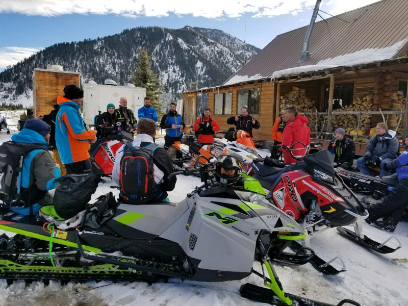
25th Annual Black Diamond Fall Fundraising Party
Thursday, September 13; 6:00-10:00 PM; Black Diamond Parking Lot
25th Annual Black Diamond Fall Fundraising Party
Thursday, September 13; 6:00-10:00 PM; Black Diamond Parking Lot
| Advisory: Uintas Area Mountains | Issued by Craig Gordon for Monday - February 19, 2018 - 3:13am |
|---|

|
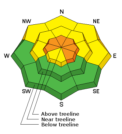
bottom line In upper elevation terrain, especially in the wind zone at and above treeline, the avalanche danger is CONSIDERABLE. Human triggered avalanches are likely on steep wind drifted slopes, facing the north half of the compass, particularly those with an easterly component to their aspect. An avalanche triggered today can quickly get out of hand if it breaks into weak layers of snow, now buried deeper in our snowpack. Yesterday's winds got into lower elevations as well. Expect MODERATE avalanche danger in mid elevation terrain and human triggered avalanches are possible on steep wind drifted slopes. LOW avalanche danger is found at mid and lower elevations on slopes facing the south half of the compass.
|
 |
special announcement
Our Sled 101 Avy Class was a brilliant success due in large part to all the support from The Edge Power Sports for sponsoring, Park City Powder Cats for hosting, and the Backcountry Institute for providing the talent. |
 |
current conditions Yesterday's cow tipping southerly winds blew in the 60's and 70's and finally pushed a solid storm our way with snow beginning to fall right around 7:00 last night. This is a North Slope favored flow with that zone quickly stacking up 10" of fresh snow. Terrain south of Trial Lake didn't get the memo and received about half that amount. In either case, northerly winds are blowing 15-25 mph along the high ridges, temperatures are in the single digits, and the storm snow is about as light as it gets. Above are 24 hour temperatures and snow depth from upper Moffit basin along with winds and temperatures from Windy Peak. More remote Uinta weather stations are found here You can find a great body of recent trip reports, observations, and snow data here.
|
 |
recent activity Sluffing and shallow soft slabs were reported on steep, wind drifted slopes. |
| type | aspect/elevation | characteristics |
|---|

|
|
LIKELIHOOD
 LIKELY
UNLIKELY
SIZE
 LARGE
SMALL
TREND
 INCREASING DANGER
SAME
DECREASING DANGER
|
|
description
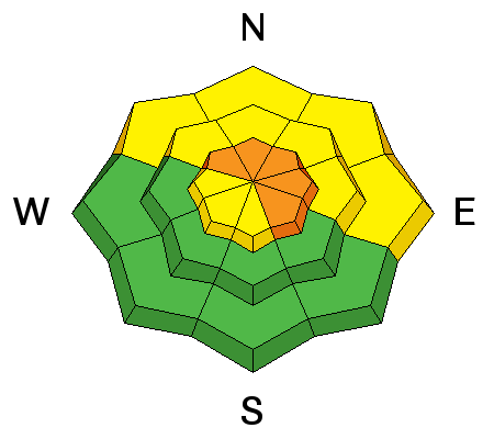
Yesterday's winds raged in the high terain, forming thick, stiff drifts along the leeward side of ridges and around terrain features like chutes and gullies. Sunday's drifts are now covered over with Monday's fresh snow, making them harder to detect. What i look for and avoid in this case is any fat rounded piece of snow, especially if it sounds hollow like a drum. In addition, yesterday's winds were all over the place and I wouldn't be surprised to find stiff slabs further downslope than we usually expect. It'll be a little tricky out there but It's not a hide under the beds kind of day. However, you'll want to be on your "A game" and gather as much information as possible. Be on the lookout for clues to unstable snow like shooting cracks out in front of your skis, board, or sled. In addition, tweak small test slopes like road banks and see how they're reacting before getting into steep, commiting terrain. |
| type | aspect/elevation | characteristics |
|---|

|
|
LIKELIHOOD
 LIKELY
UNLIKELY
SIZE
 LARGE
SMALL
TREND
INCREASING DANGER
SAME
DECREASING DANGER
|
|
description
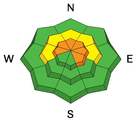
Across the range it's a tale of two snowpacks and I don't think yesterday's storm is enough water weight to tip the balance particularly where the snowpack is deep. As a matter of fact, our deeper snow zones, especially on the North Slope are comfortable in their own skin and quite resiliant... that's the good news. However, where the pack is shallow, the jury is still out. Suspect areas include terrain that has already avalanched this year along with a vast majority of steep, shady slopes on the south half of the range... from about Trial Lake through Strawberry. As always in this case, the best offense is a good defense. Simply avoid steep, rocky, wind drifted slopes, especially if they've got a "trapdoor" or punchy feeling.
Note to self.... terrain that avalanched big earlier this seaon like the south end of Double Hill pictured above, have a shallower and therfore weaker snowpack. This is the type of terrain that will light up with this weekends snow, water, and wind. |
 |
weather Round one of the big storm pushed through overnight, but another wave should work into the region later this morning with a couple inches of additional snow expected. It'll be cold with high temperatures barely cracking into the teens and overnight lows crashing well below zero. Northerly winds blow in the 20's and 30's along the high ridges. A few scattered snow showers linger on Tuesday with sunny skies on tap for Wednesday. |
| general announcements The information in this advisory expires 24 hours after the date and time posted, but will be updated by 7:00 AM Tuesday February 20th, 2018. If you're getting out and about, please let me know what you're seeing especially if you see or trigger and avalanche. I can be reached at [email protected] or 801-231-2170 It's also a good time to set up one of our very popular avalanche awareness classes. Reach out to me and I'll make it happen. This information does not apply to developed ski areas or highways where avalanche control is normally done. This advisory is from the U.S.D.A. Forest Service, which is solely responsible for its content. This advisory describes general avalanche conditions and local variations always occur. |