25th Annual Black Diamond Fall Fundraising Party
Thursday, September 13; 6:00-10:00 PM; Black Diamond Parking Lot
25th Annual Black Diamond Fall Fundraising Party
Thursday, September 13; 6:00-10:00 PM; Black Diamond Parking Lot
| Advisory: Uintas Area Mountains | Issued by Craig Gordon for Monday - January 22, 2018 - 3:44am |
|---|

|
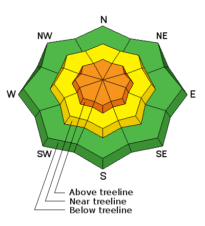
bottom line In the wind zone at and above treeline the avalanche danger is CONSIDERABLE. Human triggered avalanches are likely on steep, wind drifted slopes, especially those facing the north half of the compass. Once triggered, today's avalanches can quickly get out of hand if they break into weak layers of snow now buried several feet deep in our snowpack. Mid elevation terrain offers MODERATE avalanche danger and human triggered slides are possible on steep slopes with recent deposits of wind drifted snow Most mid and low elevation south facing slopes offer generally LOW avalanche danger.
|
 |
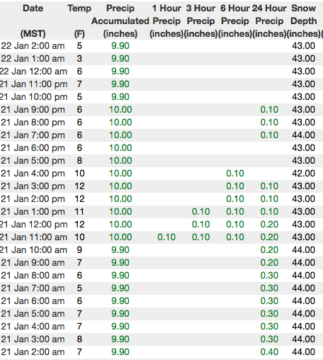
current conditions Currently, skies are partly cloudy and it's crisp with temperatures in the single digits. West and northwest winds calmed down around 2:00 yesterday and are blowing 10-15 mph even along the high peaks this morning. The weekend storm was good to the eastern front, delivering 18" of Utah, uber-fluff. Today's continued hot ticket- avoid the big, open bowls which are a bit wind jacked and hit low angle, wind sheltered terrain instead... it's over-the-hood and over-the-head :)
Above are 24 hour temperatures and snow depth from Trial Lake along with winds and temperatures from Lofty Lake Peak. More remote Uinta weather stations are found here
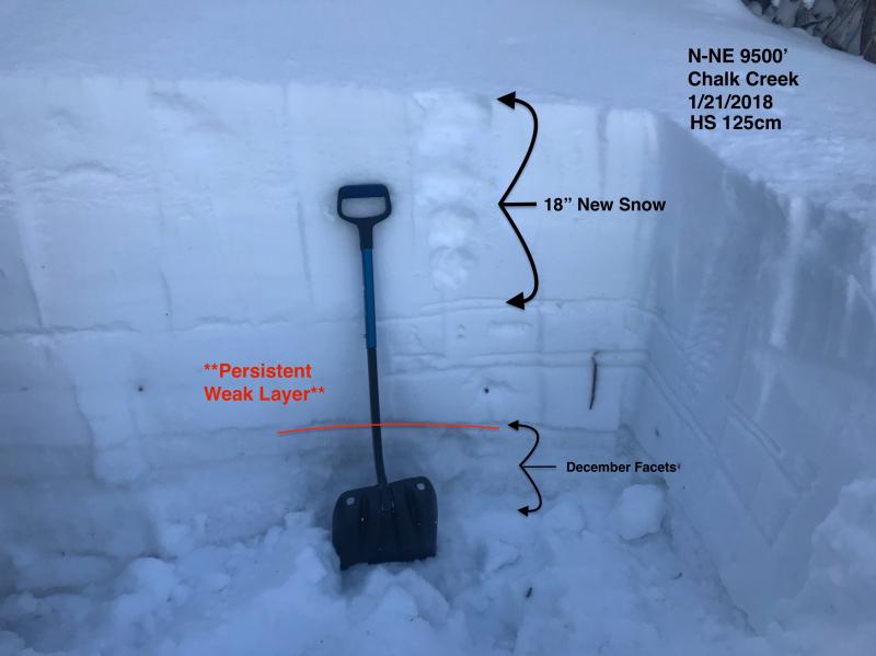
Bo and Andrew were in Chalk Creek yesterday and reported 5 star riding conditions. They posted a most excellent observation. More on their travels and insights along with a string of recent trip reports can be seen here. (Torrey/Nassetta photo)
|
 |
recent activity
|
| type | aspect/elevation | characteristics |
|---|

|
|
LIKELIHOOD
 LIKELY
UNLIKELY
SIZE
 LARGE
SMALL
TREND
 INCREASING DANGER
SAME
DECREASING DANGER
|
|
description
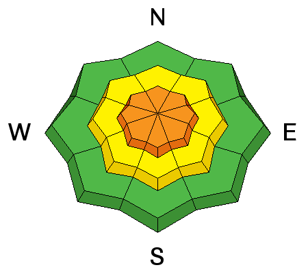
Two days of west and nothwest winds, whipped the weekend storm snow into drifts sensitive to our additional weight. While most of these slabs probably settled out overnight, I bet there's a drift or two that'll remain sensitive to our additional weight today. Newly formed pillows of snow are mostly found on the leeward side of upper elevation ridges, but I suspect you'll also find a cross-loaded pocket or two around terrain features like chutes and gullies. Look for and avoid any fat, rounded piece of snow, especially if it sounds hollow like a drum. On steep, wind drifted slopes, today's slabs can break deeper and wider than you might expect and will easily boss you around.
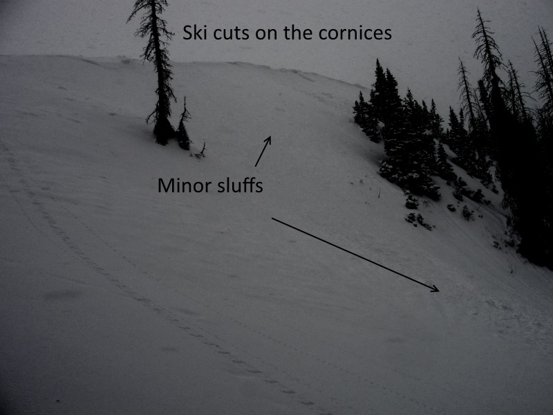
Westin D was in the Humpy Creek drainage Saturday and found shallow soft slabs reactive to his additional weight. (Deutschlander photo) |
| type | aspect/elevation | characteristics |
|---|

|
|
LIKELIHOOD
 LIKELY
UNLIKELY
SIZE
 LARGE
SMALL
TREND
INCREASING DANGER
SAME
DECREASING DANGER
|
|
description
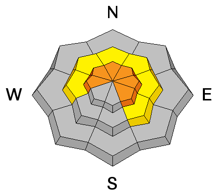
Trickier and harder to detect is the possibility of triggering an avalanche that breaks into weak layers of snow, now buried deeper in our snowpack. There's a few variables out there right now, but what I do know is... we have a complex snowpack and this seasons history reveals that each time it snows, weak layers in our midpack wake up and we see a string of human triggered slides. While this storm didn't stack up huge water numbers, it did produce fairly strong winds late Friday which created a solid feeling, cohesive slab. Problem is... the snowpack will allow us to get well out onto the slope before it fails. Once triggered, a slide breaking into weak layers of snow now buried in our midpack, will quickly get out of hand and instantly ruin our day. The most likely suspects are steep, wind drifted slopes facing north half of the compass. Since this avalanche dragon is unpredictable, the best offense is a good defense... you simply avoid it. Swing around to lower elevation south facing slopes or choose low angle terrain with no steep slopes above or adjacent to the slopes your riding. |
 |
weather Clouds increase throughout the day as a weak system slides to the north later today, giving us a few flurries. It'll be cold with highs only reaching into teens and lows dipping into the single digits. Significant warming and an increase in winds occurs tomorrow and Wednesday ahead of the next storm slated to impact the area Thursday and Friday. |
| general announcements The information in this advisory expires 24 hours after the date and time posted, but will be updated by 7:00 AM Tuesday January 23, 2018. If you're getting out and about, please let me know what you're seeing especially if you see or trigger and avalanche. I can be reached at [email protected] or 801-231-2170 It's also a good time to set up one of our very popular avalanche awareness classes. Reach out to me and I'll make it happen. This information does not apply to developed ski areas or highways where avalanche control is normally done. This advisory is from the U.S.D.A. Forest Service, which is solely responsible for its content. This advisory describes general avalanche conditions and local variations always occur. |