25th Annual Black Diamond Fall Fundraising Party
Thursday, September 13; 6:00-10:00 PM; Black Diamond Parking Lot
25th Annual Black Diamond Fall Fundraising Party
Thursday, September 13; 6:00-10:00 PM; Black Diamond Parking Lot
| Advisory: Uintas Area Mountains | Issued by Craig Gordon for Sunday - January 21, 2018 - 3:54am |
|---|

|
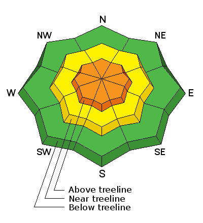
bottom line In the wind zone at and above treeline the avalanche danger is CONSIDERABLE. Human triggered avalanches are likely on steep, wind drifted slopes. Once triggered, today's avalanches can quickly get out of hand if they break into weak layers of snow now buried several feet deep in our snowpack. Mid elevation terrain offers MODERATE avalanche danger and human triggered slides are possible on steep slopes with recent deposits of wind drifted snow Most mid and low elevation south facing slopes offer generally LOW avalanche danger.
|
 |
current conditions Wow.... what a nice storm for the Eastern Front, especially for the North Slope which stacked up nearly 18" of ultra-light Utah fluff. The south half of the range didn't get the party invite, but still squeezed out about 10" of new snow. Currently, skies are cloudy, light snow is falling, and temperatures dipped into the teens and single digits overnight. West and northwest winds crashed the powder party late yesterday and have been blowing 25-35 mph since about dinnertime. Today's hot ticket- avoid the big, open bowls which are wind damaged and hit low angle, wind sheltered terrain instead... it's over-the-hood and over-the-head :)
Above are 24 hour temperatures and snow depth from Hayden Fork along with winds and temperatures from Lofty Lake Peak. More remote Uinta weather stations are found here
Micheal J was in the Hoyt Peak environs yesterday and found great riding and turning conditions along with an encouranging looking snowpack. More on his travels and insights along with a string of recent trip reports can be seen here. (Janulaitis photo)
|
 |
recent activity
|
| type | aspect/elevation | characteristics |
|---|

|
|
LIKELIHOOD
 LIKELY
UNLIKELY
SIZE
 LARGE
SMALL
TREND
 INCREASING DANGER
SAME
DECREASING DANGER
|
|
description
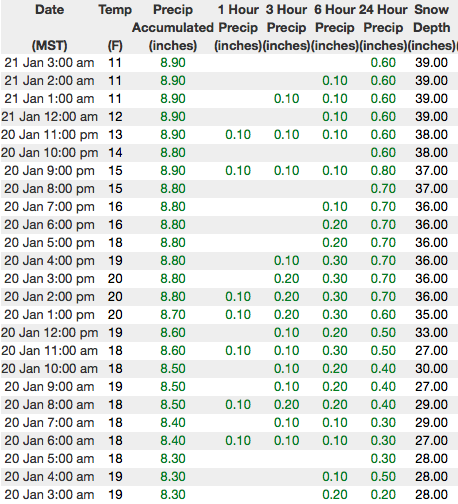
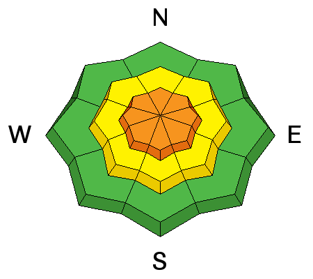
A good portion of Saturday was marked by unusually calm, windless conditions. But since the range is famous for the place that wind was invented, west and nothwest winds made their presence known late in the day and there's no shortage of light density snow to work with. Fresh drifts sensitive to our additional weight is today's most obvious avalanche concern and you'll find these newly formed pillows of snow on the leeward side of upper elevation ridges and around terrain features like chutes and gullies. Look for and avoid any fat, rounded piece of snow, especially if it sounds hollow like a drum. On steep, wind drifted slopes, today's slabs can break deeper and wider than you might expect and will easily boss you around.
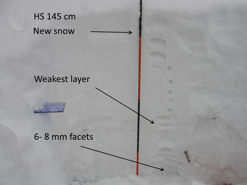
Westin D was in the Humpy Creek drainage yesterday and found shallow soft slabs reactive to his additional weight. (Deutschlander photo) |
| type | aspect/elevation | characteristics |
|---|

|
|
LIKELIHOOD
 LIKELY
UNLIKELY
SIZE
 LARGE
SMALL
TREND
INCREASING DANGER
SAME
DECREASING DANGER
|
|
description
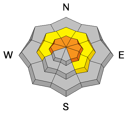
Trickier and harder to detect is the possibility of triggering an avalanche that breaks into weak layers of snow, now buried deeper in our snowpack. There's a few variables out there right now, but what I do know is... we have a complex snowpack and this seasons history reveals that each time it snows, weak layers in our midpack wake up and we see a string of human triggered slides. While this storm didn't stack up huge water numbers, it did produce fairly strong winds late Friday which created a solid feeling, cohesive slab. Problem is... the snowpack will allow us to get well out onto the slope before it fails. Once triggered, a slide breaking into weak layers of snow now buried in our midpack, will quickly get out of hand and instantly ruin our day. The most likely suspects are steep, wind drifted slopes facing north half of the compass. Since this avalanche dragon is unpredictable, the best offense is a good defense... you simply avoid it. Swing around to lower elevation south facing slopes or choose low angle terrain with no steep slopes above or adjacent to the slopes your riding. |
 |
weather Yesterday's storm is exiting the state and headed east, though we'll still see scattered snow showers through the morning. Northwest winds remain steady, blowing in the 30's and low 40's along the high ridges. Temperatures creep into the teens today and bottom out near zero degrees overnight. A weak storm grazes northern Utah late Monday with a stronger, yet fast moving system slated for late in the week. |
| general announcements The information in this advisory expires 24 hours after the date and time posted, but will be updated by 7:00 AM Monday January 22, 2018. If you're getting out and about, please let me know what you're seeing especially if you see or trigger and avalanche. I can be reached at [email protected] or 801-231-2170 It's also a good time to set up one of our very popular avalanche awareness classes. Reach out to me and I'll make it happen. This information does not apply to developed ski areas or highways where avalanche control is normally done. This advisory is from the U.S.D.A. Forest Service, which is solely responsible for its content. This advisory describes general avalanche conditions and local variations always occur. |