25th Annual Black Diamond Fall Fundraising Party
Thursday, September 13; 6:00-10:00 PM; Black Diamond Parking Lot
25th Annual Black Diamond Fall Fundraising Party
Thursday, September 13; 6:00-10:00 PM; Black Diamond Parking Lot
| Advisory: Uintas Area Mountains | Issued by Craig Gordon for Monday - January 15, 2018 - 3:38am |
|---|

|
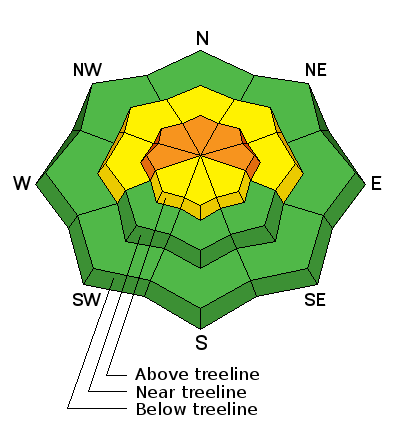
bottom line In the wind zone at and above treeline the avalanche danger is CONSIDERABLE. Human triggered avalanches are likely on steep, wind drifted slopes, especially those facing the north half of the compass and particularly those with an easterly component to their aspect. In mid elevation terrain at treeline, you'll find a MODERATE avalanche danger and human triggered slides are possible on steep slopes with recent deposits of wind drifted snow. Looking for LOW avy danger? Most mid and low elevation south facing slopes and terrain that held no snow prior to the Christmas Eve storm offer generally LOW avalanche danger.
|
 |
special announcement
This weekends Sled Avy 101 provided the crew pictured above with a solid skill-set they can take anywhere and make the right decisions based on the avalanche danger and snowpack structure. Huge thanks to Park City Powder Cats for hosting and to The Backcountry Institute for providing a bitchin' workshop. |
 |
current conditions Skies are clear with temperatures in the mid and upper 20's. West and northwest winds blow 20-25 mph along the high ridges. Last weeks storm cycle did the Eastern Front a solid, delivering just over 2' of dense, spongy snow. While it's still pretty thin out there, riding and turning conditions are quite good.
Above are 24 hour temperatures and snow depth from Trial Lake along with winds and temperatures from Lofty Lake Peak. More remote Uinta weather stations are found here Recent trip reports and findings can be seen here.
|
 |
recent activity
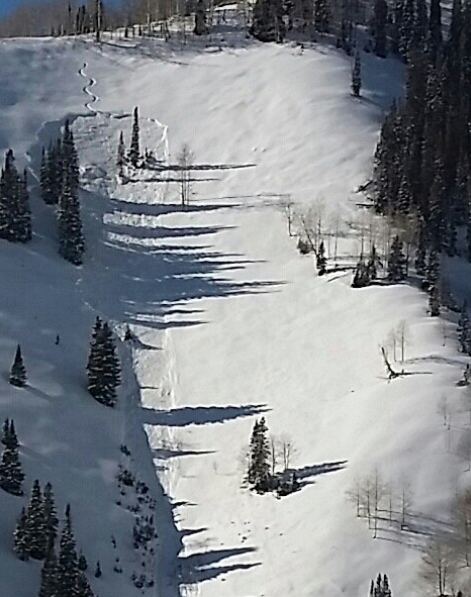
Human triggered slides continued to make headline news Saturday on the eastern front. Avalanches were triggered either mid-slope or from a distance. Common denominator- slides are failing in the midpack or close to the ground. The other common theme is steep leeward slopes facing the north half of the compass. Click here to see recent avy activity. (Boyer and Slack photos) Click HERE for a viddy showing what's going on with our snowpack. |
| type | aspect/elevation | characteristics |
|---|

|
|
LIKELIHOOD
 LIKELY
UNLIKELY
SIZE
 LARGE
SMALL
TREND
 INCREASING DANGER
SAME
DECREASING DANGER
|
|
description
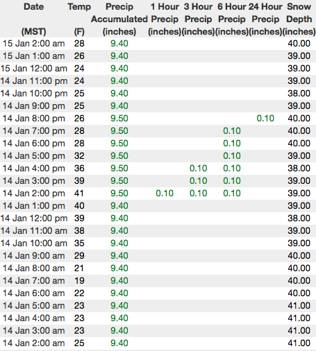
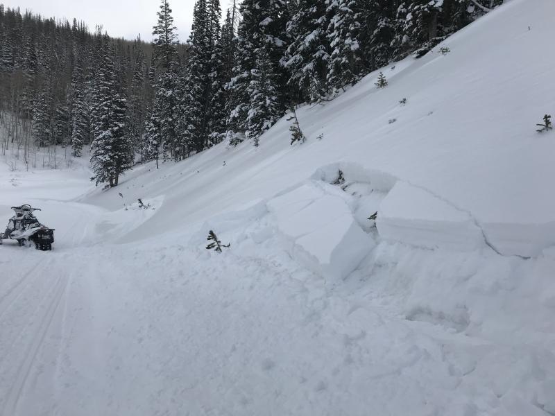
The image above is a slab triggered on Saturday by an extremely experienced, professional backcountry rider. Just a few turns into the slope, it collapsed and the slab broke above him, but fortunately he self-arrested on the bed surface and came out on top. This avalanche clearly illustrates the tricky nature of persistent slabs lurking on steep shady slopes throughout the range. What continues to make this setup tricky today is, the slab is starting to gain strength and allows you to get onto the slope before it fails. Once you've collapsed the slope, all bets are off and you're staring down the barrel of a scary slide. So here's what's going on... we finally added enough weight for avalanches to begin breaking into weak layers of snow buried in the mid portion of our snowpack. Problem is, the avalanche danger isn't in your face. You don't look around and see avalanches everywhere. On the contrary... many steep slopes still remain in the balance today, just waiting for a trigger like us to roll up and knock the legs out from underneath it. Making the current setup even more tricky is the continued possibility of triggering a slide from low on the slope or even from a distance. All of this doesn't mean you can't ride. It does mean you need to stay off of and out from under steep, wind drifted slopes. By now you know the usual suspects to avoid... steep, upper elevation, shady slopes, especially those facing the north half of the compass.
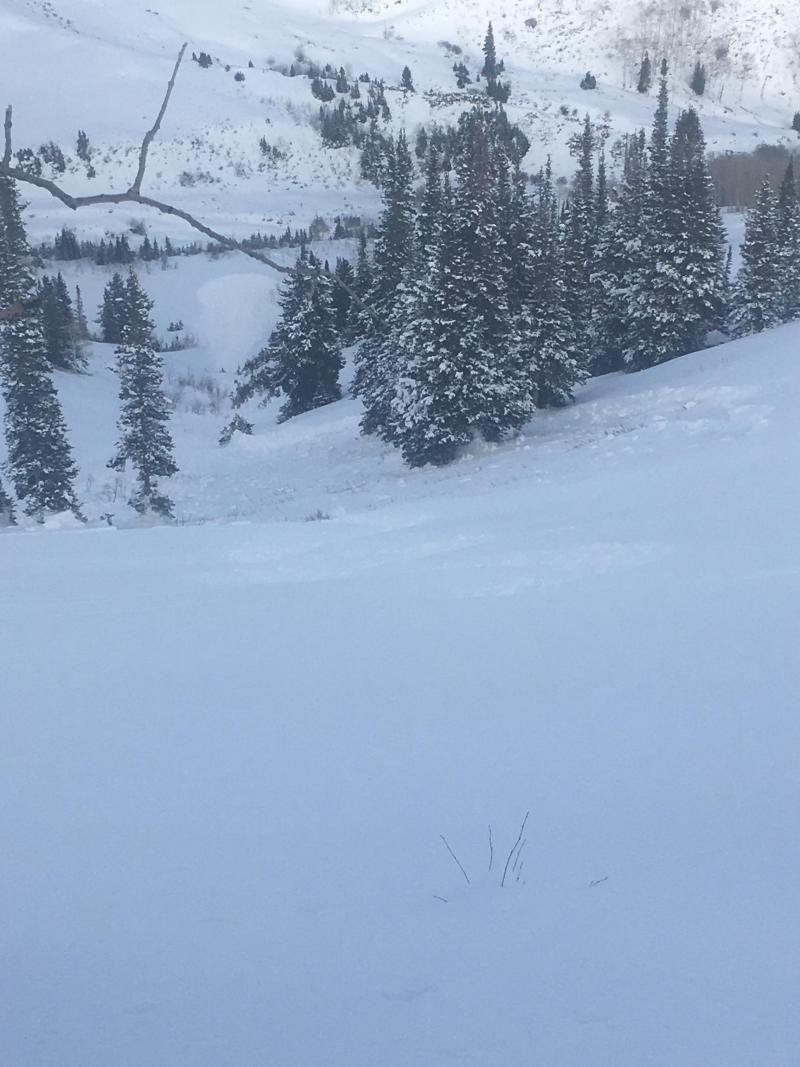
The avalanche danger is pretty apparent right out of the gates. A small avalanche like the one pictured above gives me a huge piece of information about the snow stability and the type of avalanche dragon I'm dealing with. And here's a viddy describing the setup. |
 |
weather High clouds drift into the region as the ridge over the Great Basin weakens today. Temperatures rise into the upper 30's and northerly winds remain fairly light, in the low to mid 20's along the high ridges. Clouds gradually increase through Tuesday with a chance of snow Tuesday night. Weak high pressure builds on Wednesday and Thursday before a potentially stronger system slides into the region for Friday and Saturday. |
| general announcements The information in this advisory expires 24 hours after the date and time posted, but will be updated by 7:00 AM Tuesday January 16, 2018. If you're getting out and about, please let me know what you're seeing especially if you see or trigger and avalanche. I can be reached at [email protected] or 801-231-2170 It's also a good time to set up one of our very popular avalanche awareness classes. Reach out to me and I'll make it happen. This information does not apply to developed ski areas or highways where avalanche control is normally done. This advisory is from the U.S.D.A. Forest Service, which is solely responsible for its content. This advisory describes general avalanche conditions and local variations always occur. |