25th Annual Black Diamond Fall Fundraising Party
Thursday, September 13; 6:00-10:00 PM; Black Diamond Parking Lot
25th Annual Black Diamond Fall Fundraising Party
Thursday, September 13; 6:00-10:00 PM; Black Diamond Parking Lot
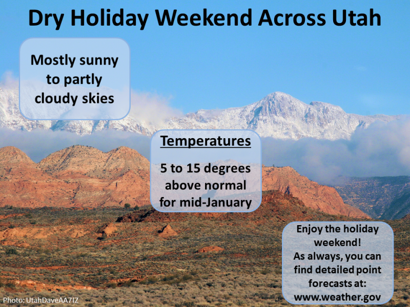
| Advisory: Uintas Area Mountains | Issued by Craig Gordon for Saturday - January 13, 2018 - 4:22am |
|---|

|
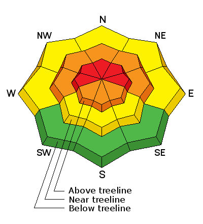
bottom line HEADS UP... THESE ARE THE KIND OF CONDITIONS THAT LEAD TO AVALANCHE ACCIDENTS! In the wind zone above treeline the avalanche danger is HIGH. Human triggered avalanches are very likely on steep, wind drifted slopes, especially those facing the north half of the compass and particularly those with an easterly component to their aspect. At treeline, you'll find a CONSIDERABLE avalanche danger and human triggered slides are likely on steep slopes with recent deposits of wind drifted snow. While not as widespread, MODERATE avalanche danger is found at lower elevations and human triggered avalanches are possible on steep, shady slopes. Looking for LOW avy danger? Most mid and low elevation south facing slopes and terrain that held no snow prior to the Christmas Eve storm offer generally LOW avalanche danger.
|
 |
special avalanche bulletin THE FOREST SERVICE UTAH AVALANCHE CENTER IN SALT LAKE CITY HAS ISSUED A BACKCOUNTRY AVALANCHE SPECIAL BULLETIN. * TIMING…IN EFFECT FROM 9 PM MST FRIDAY TO 9 PM MST MONDAY * AFFECTED AREA…FOR THE MOUNTAINS OF NORTHERN UTAH INCLUDING THE WASATCH RANGE...BEAR RIVER RANGE...UINTA MOUNTAINS. * AVALANCHE DANGER…THE AVALANCHE DANGER IN THE WESTERN UINTAS REMAINS HIGH WHICH MEANS HUMAN TRIGGERED AVALANCHES ARE VERY LIKELY. * IMPACTS…BEAUTIFUL WEATHER OVER THE HOLIDAY WEEKEND AND RECENT FRESH POWDER SNOW WILL LEAD TO A SIGNIFICANT INCREASE IN PUBLIC USE IN THE MOUNTAINS OF NORTHERN UTAH. SNOWPACK, WEATHER, AND HUMAN CONDITIONS ARE PERFECTLY ALIGNED FOR A POTENTIAL ACCIDENT THIS WEEKEND. MANY SLOPES, ESPECIALLY ONES ABOVE 8000 FT WITH A NORTHERLY THROUGH EASTERLY ASPECT, ONLY NEED A SKIER OR RIDER TO TRIGGER AN AVALANCHE 2-3 FEET DEEP AND SEVERAL HUNDRED FEET WIDE. BACKCOUNTRY TRAVELERS SHOULD CONSULT WWW.UTAHAVALANCHECENTER.ORG OR CALL 1-888-999-4019 FOR MORE DETAILED INFORMATION. THIS WARNING DOES NOT APPLY TO SKI AREAS WHERE AVALANCHE HAZARD REDUCTION MEASURES ARE PERFORMED. |
 |
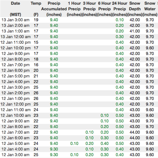
current conditions Moisture lingers over the region and skies are mostly cloudy this morning. West and northwest winds cranked into the 50's and 60's yesterday, but relaxed midday and are currently blowing 25-35 mph along the high ridges. Temperatures are in the teens and low 20's. Since Saturday January 6th, the range accumulated 18" of snow with close to 2" of water. Most snow sites still register just over 3' of settled snow. While it's still super boney out there, riding and turning conditions have vastly improved the past few days.
Above are 24 hour temperatures and snow depth from Trial Lake. I'm have comms issues at some of our wind site locations and we'll try to get that ironed out today. More remote Uinta weather stations are found here Recent trip reports and findings can be seen here.
Trenchtown Rock... Tyler found deep snow, but sketchy snowpack structure near Spring Canyon yesterday. More on his travels and insight of the current snow stabilty setup are found here. |
 |
recent activity
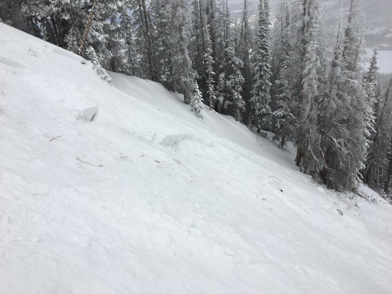
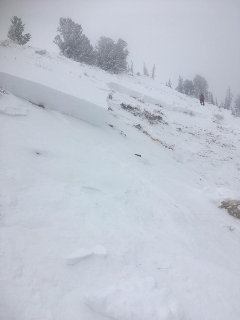
It was touchy Thursday and slides were easily initiated from adjacent terrain and low on the slope. Nearly all the activity revolves around weak sugary snow failing in the midpack or close to the ground. The other common theme is steep leeward slopes facing the north half of the compass. Click here to see recent avy activity. (Boyer/Kikkert photo) Click here to see what's going on with our snowpack. |
| type | aspect/elevation | characteristics |
|---|

|
|
LIKELIHOOD
 LIKELY
UNLIKELY
SIZE
 LARGE
SMALL
TREND
 INCREASING DANGER
SAME
DECREASING DANGER
|
|
description
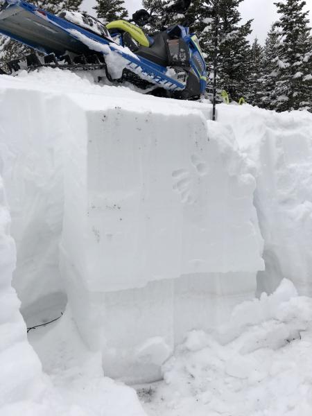
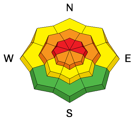
Winds started cranking yesterday morning and with plenty of fresh snow to work with, fresh slabs rapidly formed on the leeward side of upper elevation ridges. While not quite as sensitive today, you still need to look for and avoid any recent deposit of wind drifted snow, especially if it's fat and rounded or sounds hollow like a drum. Once triggered, today's drifts may quickly get out of hand, especially if they break into weak layers now buried deeper in our snowpack.
In the early stages of the storm we were dealing with shallow drifts like the one pictured above. Today's slabs are the bigger, bigger brother version... breaking deeper and wider than you might expect. |
| type | aspect/elevation | characteristics |
|---|

|
|
LIKELIHOOD
LIKELY
UNLIKELY
SIZE
 LARGE
SMALL
TREND
INCREASING DANGER
SAME
DECREASING DANGER
|
|
description
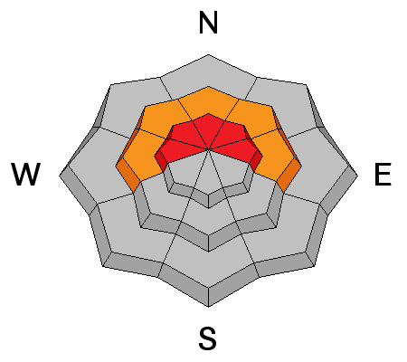
We finally added enough weight for avalanches to begin breaking into weak layers of snow buried in our midpack. While we haven't seen a widespread natural avalanche cycle, many steep slopes remain in the balance today, just waiting for a trigger like us to roll up and knock the legs out from underneath it. Making the current setup even more tricky is the continued possibility of triggering a slide from low on the slope, from a distance, or even from an adjacent slope. (Boyer/Kikkert photo) All of this doesn't mean you can't ride. It does mean you need to stay off of and out from under steep, wind drifted slopes. By now you know the usual suspects to avoid... steep, upper elevation, shady slopes, especially those facing the north half of the compass. |
 |
weather
|
| general announcements The information in this advisory expires 24 hours after the date and time posted, but will be updated by 7:00 AM Sunday January 14, 2018. If you're getting out and about, please let me know what you're seeing especially if you see or trigger and avalanche. I can be reached at [email protected] or 801-231-2170 It's also a good time to set up one of our very popular avalanche awareness classes. Reach out to me and I'll make it happen. This information does not apply to developed ski areas or highways where avalanche control is normally done. This advisory is from the U.S.D.A. Forest Service, which is solely responsible for its content. This advisory describes general avalanche conditions and local variations always occur. |