25th Annual Black Diamond Fall Fundraising Party
Thursday, September 13; 6:00-10:00 PM; Black Diamond Parking Lot
25th Annual Black Diamond Fall Fundraising Party
Thursday, September 13; 6:00-10:00 PM; Black Diamond Parking Lot
| Advisory: Uintas Area Mountains | Issued by Craig Gordon for Thursday - January 11, 2018 - 3:04am |
|---|

|
bottom line HEADS UP... IT'S GONNA REMAIN TRICKY TODAY! In the wind zone at and above treeline the avalanche danger is HIGH. Human triggered avalanches are likely on steep, wind drifted slopes, especially those facing the north half of the compass and particularly those with an easterly component to their aspect. Mid elevation terrain is equally as spooky where you'll find CONSIDERABLE avalanche danger. Human triggered avalanches are probable on steep slopes with recent deposits of wind drifted snow. Looking for LOW avy danger? Most mid and low elevation south facing slopes and terrain that held no snow prior to the Christmas Eve storm offer generally LOW avalanche danger.
|
 |
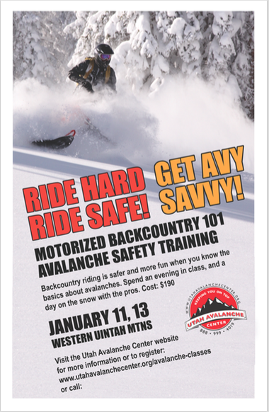
special announcement
We still have a few open slots available for this weeks Motorized Backcountry 101 Workshop. Click here for more details and to register. |
 |
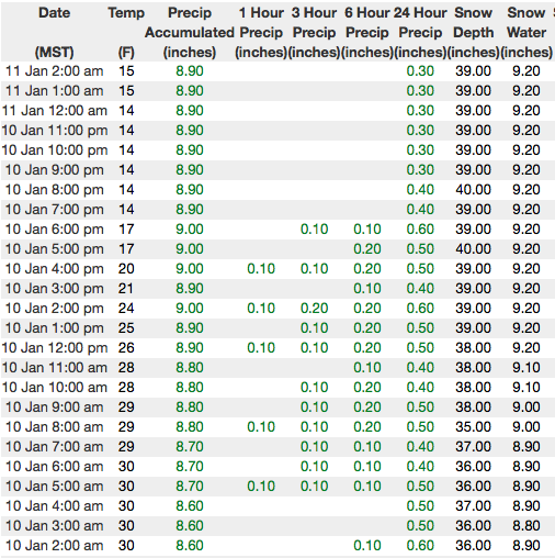
current conditions Skies cleared late yesterday and temperatures crashed into the teens and single digits overnight. West and northwest winds are blowing in the 30's and 40's along the high peaks. We stacked up a couple of inches of snow yesterday, bringing our storm totals to just over a foot since Saturday. With water totals nearing 1.5" our snowpack has gained a bit of body. While it's still super boney out there, riding and turning conditions have vastly improved the past few days.
Above are 24 hour temperatures and snow depth from Trial Lake. I'm have comms issues at some of our wind site locations and we'll try to get that ironed out today. More remote Uinta weather stations are found here Recent trip reports and findings can be seen here. |
 |
recent activity
Click here to see what's going on with our snowpack. |
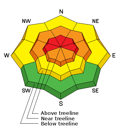
| type | aspect/elevation | characteristics |
|---|

|
|
LIKELIHOOD
 LIKELY
UNLIKELY
SIZE
 LARGE
SMALL
TREND
 INCREASING DANGER
SAME
DECREASING DANGER
|
|
description
Probably not quite as tender or reactive as yesterday, both old and new wind drifts are today's most obvious avalanche hazard. Found mostly on the leeward side of upper elevation ridges, I wouldn't be too shocked to stumble across a drift or two cross-loaded around a sub-ridge, gully wall, or chute. Today, you'll want to look for and avoid any recent deposit of wind drifted snow, especially if it's fat and rounded or sounds hollow like a drum. Once triggered, today's drifts may quicly get out of hand, especially if they break into weak layers now buried deeper in our snowpack.
In the early stages of the storm we were dealing with shallow drifts like the one pictured above. Today's slabs are the bigger brother version... breaking deeper and wider than you might expect. |
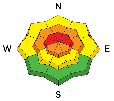
| type | aspect/elevation | characteristics |
|---|

|
|
LIKELIHOOD
LIKELY
UNLIKELY
SIZE
 LARGE
SMALL
TREND
INCREASING DANGER
SAME
DECREASING DANGER
|
|
description
Yesterday was the tipping point and we finally added enough weight for avalanches to begin breaking into weak layers of snow buried in our midpack. While I didn't receive reports of a widespread natural avalanche cycle, I bet many steep slopes are in the balance today, just waiting for a trigger like us to roll up and knock the legs out from underneath it. Making the current setup even more tricky is the continued possibility of triggering a slide from low on the slope, from a distance, or even from an adjacent slope. All of this doesn't mean you can't ride. It does mean you need to stay off of and out from under steep, wind drifted slopes. By now you know the usual suspects to avoid... steep, upper elevation, shady slopes, especially those facing the north half of the compass. |
 |
weather A weak storm brings in high clouds with a slight chance of snow late tonight. West and northwest winds blow in the 30's and 40's today and high temperatures warm into the upper 20's and low 30's. High pressure builds for late Friday through the weekend giving us mostly sunny skies and warming temperatures. |
| general announcements The information in this advisory expires 24 hours after the date and time posted, but will be updated by 7:00 AM Friday January 12, 2018. If you're getting out and about, please let me know what you're seeing especially if you see or trigger and avalanche. I can be reached at [email protected] or 801-231-2170 It's also a good time to set up one of our very popular avalanche awareness classes. Reach out to me and I'll make it happen. This information does not apply to developed ski areas or highways where avalanche control is normally done. This advisory is from the U.S.D.A. Forest Service, which is solely responsible for its content. This advisory describes general avalanche conditions and local variations always occur. |