25th Annual Black Diamond Fall Fundraising Party
Thursday, September 13; 6:00-10:00 PM; Black Diamond Parking Lot
25th Annual Black Diamond Fall Fundraising Party
Thursday, September 13; 6:00-10:00 PM; Black Diamond Parking Lot
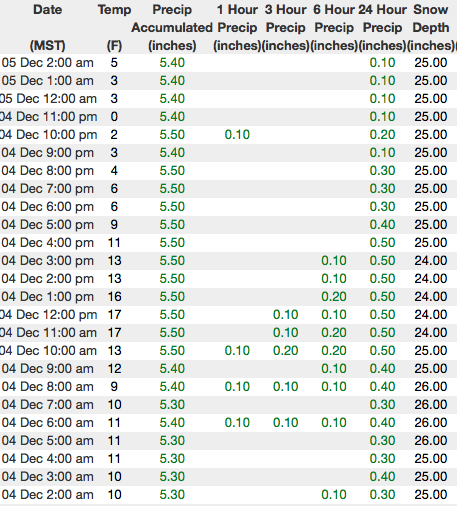
| Advisory: Uintas Area Mountains | Issued by Craig Gordon for Tuesday - December 5, 2017 - 2:56am |
|---|

|
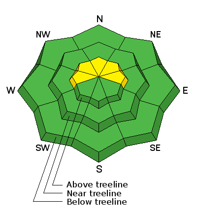
bottom line At and above treeline, a MODERATE avalanche danger exists. This means human triggered avalanches are possible on steep wind drifted slopes, particularly those facing the north half of the compass. Remember- any slide that breaks to old snow near the ground is going to instantly ruin your day as you get slammed into rocks and stumps, barely hidden under the thin facade of our shallow snowpack. LOW avalanche danger is found on south facing slopes and terrain that had no snow prior to Sunday's storm.
|
 |
special announcement With no dramatic changes in the weather and no storms in sight, I'll update this advisory by 7:00 am, Saturday December 9th. |
 |
current conditions Skies cleared late last night revealing the waning stages of a big, bright, beautiful moon. With no cloud cover, temperatures have crashed to near zero. East and northeast winds are relatively well behaved blowing in the low to mid 20's. Sunday's storm delivered about a foot of fresh snow, but total snow depths are still in the infant stage and there's only 18"-24", limiting travel to road rides and grassy meadows.
|
 |
recent activity No recent avalanche activity to report. |
| type | aspect/elevation | characteristics |
|---|

|
|
LIKELIHOOD
 LIKELY
UNLIKELY
SIZE
 LARGE
SMALL
TREND
 INCREASING DANGER
SAME
DECREASING DANGER
|
|
description
Sunday night's storm was a good shot in the arm for our snowpack and I bet the range experienced a natural avalanche cycle on steep, upper elevation, wind drifted slopes. Unfortunately, we're drawn to this exact type of terrain because those upper elevation, shady slopes have the best coverage and we won't be slamming into rocks. Sounds pretty straight-forward, but here's where it gets tricky... terrain that didn't avalanche is waiting for a trigger like us to come along and knock the legs out from under the slab. Remember-there's some junk in the trunk and steep, upper elevation, shady slopes facing the north half of the compass have a house of cards snow structure. While the snowpack adjusts to the big wekend storm, the key to avalanche avoidance is to simply steer clear of terrain with these characteristics. Instead of rolling the dice, head to slopes that had no snow prior to the storm.
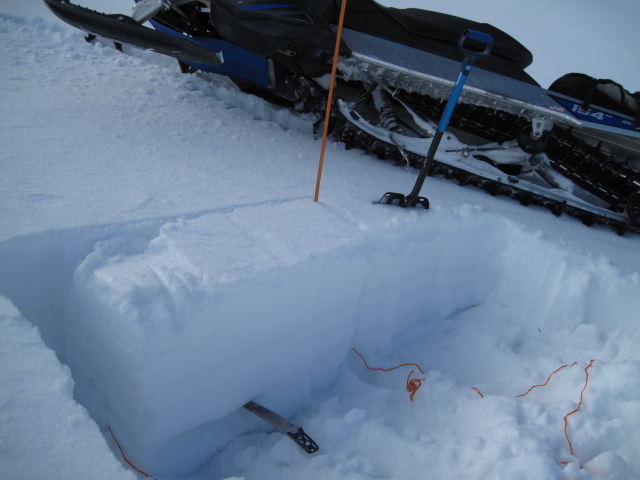
Ted was in Whitney Basin prior to the storm and found cohesive snow resting on weak factes... clearly illustrated in the image above. Click here for Ted's great video recap. |
 |
weather
Today we can expect clear skies with temperatures climbing into the low 20's and overnight lows dipping into the single digits. Winds veer to the north and blow in the 20's along the high ridges. High pressure settles into the area for the rest of the week, bringing dry conditions, and a warming trend. No big pattern change in sight. |
| general announcements I'll up date this advisory by 7:00 AM Friday December 8, 2017. If you're getting out and about, please let me know what you're seeing especially if you see or trigger and avalanche. I can be reached at [email protected] or 801-231-2170 It's also a good time to set up one of our very popular avalanche awareness classes. Reach out to me and I'll make it happen. This information does not apply to developed ski areas or highways where avalanche control is normally done. This advisory is from the U.S.D.A. Forest Service, which is solely responsible for its content. This advisory describes general avalanche conditions and local variations always occur. |