25th Annual Black Diamond Fall Fundraising Party
Thursday, September 13; 6:00-10:00 PM; Black Diamond Parking Lot
25th Annual Black Diamond Fall Fundraising Party
Thursday, September 13; 6:00-10:00 PM; Black Diamond Parking Lot
| Advisory: Uintas Area Mountains | Issued by Craig Gordon for Sunday - April 9, 2017 - 4:47am |
|---|

|
bottom line In the wind zone, at and above treeline, the avalanche danger is MODERATE. Human triggered avalanches are possible on steep, wind drifted, leeward slopes. Lose the wind and you lose the problem. Wind sheltered terrain offers LOW avalanche danger and great riding
|
 |
special announcement Next Sunday, April 16th will be the last of the regularly scheduled western Uinta Advisories |
 |
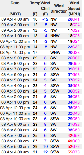
current conditions Our storm was a bit underwhelming, but finally materialized late in the day and set its sights on the North Slope where 5" of medium density snow stacked up. The southern half of the range managed to squeak out about 3". In the wake of the storm skies are mostly cloudy and a few light snow showers linger over the region. Temperatures crashed into the teens overnight and Northwest winds are blowing 20-40 mph along the high ridges. Riding and turning conditions improved drastically with our fresh coat of white paint and low angle slopes are gonna be the ticket to avoid bottom feeding.
Above... 24 hour wind data from Windy Peak (10,166') and current snow depths at Trial Lake (9,992') Real time temperatures, snowfall and wind for the western Uintas are found here. Snowpack observations and trip reports are found here. |
 |
recent activity No significant avalanches to report from yesterday. A full list of Uinta avalanche activity is found here. |
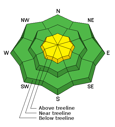
| type | aspect/elevation | characteristics |
|---|

|
|
LIKELIHOOD
 LIKELY
UNLIKELY
SIZE
 LARGE
SMALL
TREND
 INCREASING DANGER
SAME
DECREASING DANGER
|
|
description
Winds have been all over the place the past 24 hours and they finally have some snow to work with. However, with just 5" of fresh snow it's not like the Uintas got stomped on and it's epically deep. As a matter of fact, I think our avalanches problems are pretty straight-forward and confined to upper elevation slopes in the wind zone. The thing to keep in mind is that avalanhe conditions can change very rapidly this time of year, especially if the sun pokes out for any length of time. Also, if you're hopping from one drainage to another take a moment or two and reassess the conditions before dropping in. And finally, look for and avoid any fat, rounded piece of snow, particualrly if it feels or sounds hollow like a drum. |
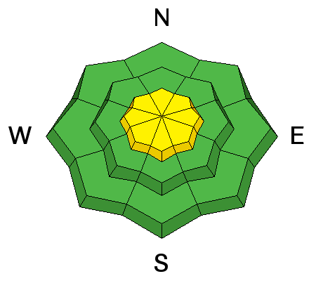
| type | aspect/elevation | characteristics |
|---|

|
|
LIKELIHOOD
 LIKELY
UNLIKELY
SIZE
 LARGE
SMALL
TREND
 INCREASING DANGER
SAME
DECREASING DANGER
|
|
description
Paul Diegel, Executive Director of the Friends of the UAC was near Bald Mountain and said this about our corni. "Cornices remain massive and hostile-looking, in some cases on both sides of ridgelines. These are going to fail spectacularly and it would be bad to be within striking range when that happens." His trip report is found here. (Weston D images) |
 |
weather Expect light snow showers this morning with partly cloudy skies developing by afternoon. High temperatures climb into the 20's with overnight lows dipping into the teens. Northwest winds blow in the 30's along the ridges, but should taper off as the day progresses. A drier, west to southwest flow develops tonight and persists through Tuesday with a gradual warming trend. |
| general announcements Remember your information can save lives. If you see anything we should know about, please participate in the creation of our own community avalanche advisory by submitting snow and avalanche conditions. You can call me directly at 801-231-2170, email [email protected] The information in this advisory is from the US Forest Service which is solely responsible for its content. This advisory describes general avalanche conditions and local variations always occur. The information in this advisory expires 24 hours after the date and time posted, but will be updated by 7:00 AM on Monday April 10th. |