25th Annual Black Diamond Fall Fundraising Party
Thursday, September 13; 6:00-10:00 PM; Black Diamond Parking Lot
25th Annual Black Diamond Fall Fundraising Party
Thursday, September 13; 6:00-10:00 PM; Black Diamond Parking Lot
| Advisory: Uintas Area Mountains | Issued by Craig Gordon for Monday - April 3, 2017 - 4:16am |
|---|

|
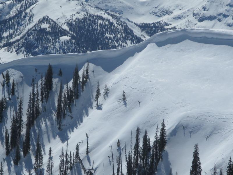
bottom line While not widespread and making up a small portion of the terrain available to ride in today, at and above treeline in the wind zone, you'll find pockets of MODERATE avalanche danger. Human triggered avalanches are POSSIBLE on steep, wind drifted slopes. Wind sheltered low and mid elevation terrain offers generally LOW avalanche danger.
|
 |
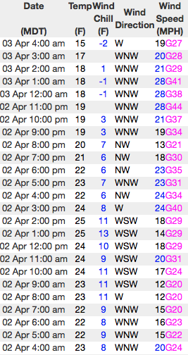
current conditions Yesterday's storm was a bit underwhelming, producing just an inch of new snow. In its wake, skies are partly cloudy and temperatures in the teens and low 20's. West and northwest winds are blowing 20-30 along the high ridges. You gotta really hunt around for soft snow, but I think there's still a few patches on upper elevation, wind sheltered slopes... getting there this morning might be a bit rugged. A mid elevation corn harvest might be a better bet.
Above... 24 hour winds from Windy Peak (10,166') and a solid snowpack at the Trial Lake snotel site (9,992') Real time temperatures, snowfall and wind for the western Uintas are found here. Snowpack observations and trip reports are found here. |
 |
recent activity No significant avalanches to report from yesterday. A full list of Uinta avalanche activity is found here. |
| type | aspect/elevation | characteristics |
|---|

|

|
LIKELIHOOD
 LIKELY
UNLIKELY
SIZE
 LARGE
SMALL
TREND
 INCREASING DANGER
SAME
DECREASING DANGER
|
|
description
With just an inch of snow to blow around and a strong, solid base underneath, our snowpack is bomber and I think most of our terrain is good to go. None-the-less, if you're getting after it and charging into steep, committing terrain remember that even a small slide can take you for an unexpected ride. So, as always, look for and avoid any fat, rounded piece of snow, especially if it feels or sounds hollow like a drum. |
| type | aspect/elevation | characteristics |
|---|

|
|
LIKELIHOOD
 LIKELY
UNLIKELY
SIZE
 LARGE
SMALL
TREND
INCREASING DANGER
SAME
DECREASING DANGER
|
|
description
While today's corni might not be overly sensitive, these boxcar monsters are completely unpredictable and should definitely be avoided. |
 |
weather We're in between two storm systems and that produces partly cloudy skies, a few flurries, and cooler temperatures. High temperatures reach into the low 30's and northwest winds blow in the 20's along the high ridges. About the same for Tuesday and then a midweek warm up is slated before a promising storm develops for late in the week. |
| general announcements Remember your information can save lives. If you see anything we should know about, please participate in the creation of our own community avalanche advisory by submitting snow and avalanche conditions. You can call me directly at 801-231-2170, email [email protected] The information in this advisory is from the US Forest Service which is solely responsible for its content. This advisory describes general avalanche conditions and local variations always occur. The information in this advisory expires 24 hours after the date and time posted, but will be updated by 7:00 AM on Tuesday April 4th. |