25th Annual Black Diamond Fall Fundraising Party
Thursday, September 13; 6:00-10:00 PM; Black Diamond Parking Lot
25th Annual Black Diamond Fall Fundraising Party
Thursday, September 13; 6:00-10:00 PM; Black Diamond Parking Lot
| Advisory: Uintas Area Mountains | Issued by Craig Gordon for Friday - March 24, 2017 - 3:34am |
|---|

|
bottom line This morning the avalanche danger is generally LOW. As the day wares on and the sun bakes the snow surface the avalanche danger rises to MODERATE and human triggered avalanches are POSSIBLE on all steep sun-exposed slopes.
|
 |
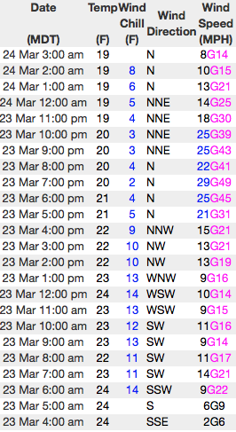
current conditions Yesterday's storm didn't quite materialize as expected and storm totals are right around 4". None-the-less a fresh coat of white blanketed the mountains and with clear skies overnight, temperatures are more winter-like... in the teens and mid 20's. Northerly winds bumped into the 30's and 40's right around dinnertime, but have since backed off and currently register 10-15 mph along the high ridges. Wanna avoid bottom-feeding but still get in a good day of riding? I thought you did and low angle slopes with smooth snow underneath are the ticket today.
Real time wind, snow, and temperatures for the Uinta's are found here Snowpack observations and trip reports are found here. |
 |
recent activity No significant avalanche activity to report from yesterday. A full list of Uinta avalanche activity is found here. |
| type | aspect/elevation | characteristics |
|---|

|
|
LIKELIHOOD
 LIKELY
UNLIKELY
SIZE
 LARGE
SMALL
TREND
 INCREASING DANGER
SAME
DECREASING DANGER
|
|
description
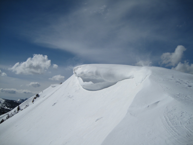
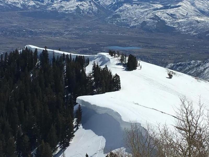
While there may be a shallow wind drift or two along the leeward side of upper elevation ridges, our main avalanche problem still revolves around damp shallow sluffs and wet slides. The sun is high in the sky and it's beating down on every aspect and every elevation. The good news is, last night's cold temperatures provided the snowpack with a solid refreeze and I think we'll get a good poriton of the day under our belts before things tuen damp and sloppy. But wait... there's more good news. Today's avalanche problem is easy to deal with by simply avoiding steep slopes during the heat of the day, especially if they have that "trap door" unsupportable feeling. In addition, you'll wanna steer clear of terrain traps like gullies and road cuts where even a small avalanche can stack up cement-like debris very deeply. |
| type | aspect/elevation | characteristics |
|---|

|

|
LIKELIHOOD
LIKELY
UNLIKELY
SIZE
 LARGE
SMALL
TREND
INCREASING DANGER
SAME
DECREASING DANGER
|
|
description
|
 |
weather It'll be a stunning day in the mountains with sunny skies, light winds, and temperatures climbing into the low 40's. Ahead of the next storm slated for tomorrow, southwest winds ramp up slightly and should blow in the 20's and 30's by late in the day. The next storm system slides through the area tomorrow. It'll be a quick hitter with just a few inches of snow, and then high pressure builds for Sunday with another system in the queue for Tuesday.
|
| general announcements Remember your information can save lives. If you see anything we should know about, please participate in the creation of our own community avalanche advisory by submitting snow and avalanche conditions. You can call me directly at 801-231-2170, email [email protected] The information in this advisory is from the US Forest Service which is solely responsible for its content. This advisory describes general avalanche conditions and local variations always occur. The information in this advisory expires 24 hours after the date and time posted, but will be updated by 7:00 AM on Saturday March 25th. |