25th Annual Black Diamond Fall Fundraising Party
Thursday, September 13; 6:00-10:00 PM; Black Diamond Parking Lot
25th Annual Black Diamond Fall Fundraising Party
Thursday, September 13; 6:00-10:00 PM; Black Diamond Parking Lot
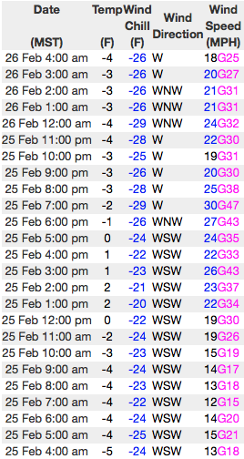
| Advisory: Uintas Area Mountains | Issued by Craig Gordon for Sunday - February 26, 2017 - 4:18am |
|---|

|
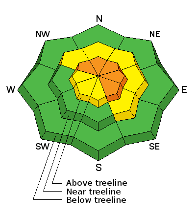
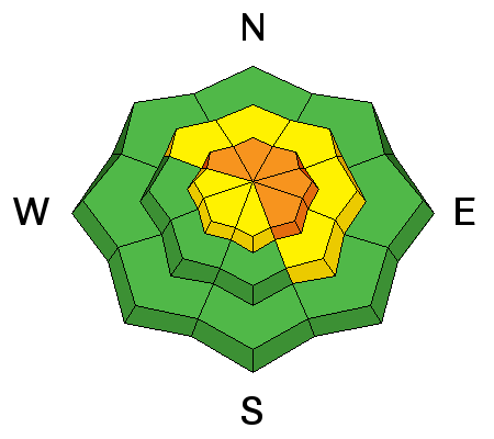
bottom line While not widespread and confined to terrain in the wind zone, you'll find pockets of CONSIDERABLE avalanche danger. Human triggered avalanches are LIKELY on steep wind drifted slopes facing the north half of the compass and especially in terrain with an easterly component to its aspect. While less pronounced, a MODERATE avalanche danger is found in mid elevation terrain and human triggered avalanches are possible on steep slopes with recent deposits of wind drifted snow. Wind sheltered slopes in mid and lower elevations offer LOW avalanche danger.
|
 |
current conditions Yesterday's cold little storm ushered in frosty temperatures and delivered just and inch or two of snow. Under clear skies, temperatures register in negative territory, and westerly winds are blowing 20-30 mph along the high ridges. With sunny skies on tap, a couple feet of fresh snow, and a go anywhere supportable base... riding and turning conditions are about as good as they get.
Real time wind, snow, and temperatures for the Uinta's are found here Snowpack observations and trip reports are found here. |
 |
recent activity Other than some cracking and a few shallow softs slabs, the snowpack has been remarkably well behaved and avalanche conditions are pretty straight-forward. A full list of Uinta avalanche activity is found here. |
| type | aspect/elevation | characteristics |
|---|

|
|
LIKELIHOOD
 LIKELY
UNLIKELY
SIZE
 LARGE
SMALL
TREND
 INCREASING DANGER
SAME
DECREASING DANGER
|
|
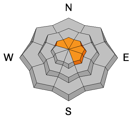
description
Ted and I stomped around on mid and upper elevation ridges yesterday and found a few fresh wind drifts, but in general, things aren't nearly as reactive or tender as they've been the past few days. However, we've got no shortage of light density snow available to blow around and the Uinta's are a big place. That said, I'm sure there's a wind drift or two lurking on the leeward side of an upper elvation ridge, or around a terrain feature like a chute or gully wall that'll react to our additional weight. Predictably breaking at or below our skis, board, or sled and failing about a foot deep, these are the kind of avalanches that most high-end sledders can manage, but are gonna be large enough to boss around a skier, boarder, or snowshoer. No matter what we ride, gather some solid beta by stomping on road cuts and test slopes and see how they're reacting before charging into steep, committing terrain. |
| type | aspect/elevation | characteristics |
|---|

|
|
LIKELIHOOD
 LIKELY
UNLIKELY
SIZE
 LARGE
SMALL
TREND
 INCREASING DANGER
SAME
DECREASING DANGER
|
|
description
Ridgeline corni are ginormous this year. These unpredictable boxcar monsters are breaking further back than you'd think, and can easily take you for an unexpected, terrifying, elevator ride to the ground floor. |
 |
weather Expect increasing clouds as the day progresses with highs reaching into the low 20's. Westerly winds ramp up later in the day and should be blowing in the 50's by about dinnertime. The next storm system arrives after midnight and continues at through Tuesday evening. We might be able to squeak a foot of snow out of this system by Wednesday morning.
|
| general announcements Remember your information can save lives. If you see anything we should know about, please participate in the creation of our own community avalanche advisory by submitting snow and avalanche conditions. You can call me directly at 801-231-2170, email [email protected] The information in this advisory is from the US Forest Service which is solely responsible for its content. This advisory describes general avalanche conditions and local variations always occur. The information in this advisory expires 24 hours after the date and time posted, but will be updated by 7:00 AM on Monday February 27th. |