25th Annual Black Diamond Fall Fundraising Party
Thursday, September 13; 6:00-10:00 PM; Black Diamond Parking Lot
25th Annual Black Diamond Fall Fundraising Party
Thursday, September 13; 6:00-10:00 PM; Black Diamond Parking Lot
| Advisory: Uintas Area Mountains | Issued by Craig Gordon for Thursday - February 9, 2017 - 3:25am |
|---|

|
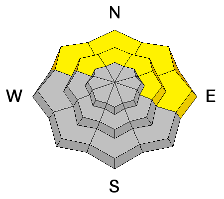
bottom line At and above treeline, the avalanche danger is MODERATE and human triggered avalanches are possible on steep wind drifted slopes. In addition, a MODERATE avalanche danger exists on steep wind sheltered terrain facing the north half of the compass where you could still trigger a slide that breaks to weak snow now buried several feet deep. Human triggered wet avalanches are possible at lower elevations and the avalanche danger may rise to MODERATE with daytime heating and low elevation rain.
|
 |
special announcement We still have a few slots open for this weeks Sled Specific Avy Awareness and Riding Skills Class. More details here. Do you buy groceries at Smiths? When you register your Smith’s rewards card with their Community Rewards program, they will donate to the Utah Avalanche Center whenever you make a purchase. It's easy, only takes a minute, and doesn't cost you anything. Details here. |
 |
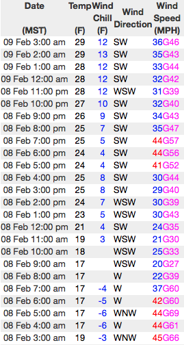
current conditions Clouds drifted into the region overnight and temperatures are unusually warm, in the 30's and low 40's. Southwest winds continue to blow in the 40's along the high ridges. Unfortunately, strong winds and recent warm temperatures ruined a lot of good snow and it's a mixed bag. Wind sheltered shady slopes are still your best option for soft, settled snow.
Real time wind, snow, and temperatures for the Uinta's are found here
... severely damaging the snow surface and welding it in place in big, open alpine terrain. Snowpack observations and trip reports are found here. |
 |
recent activity
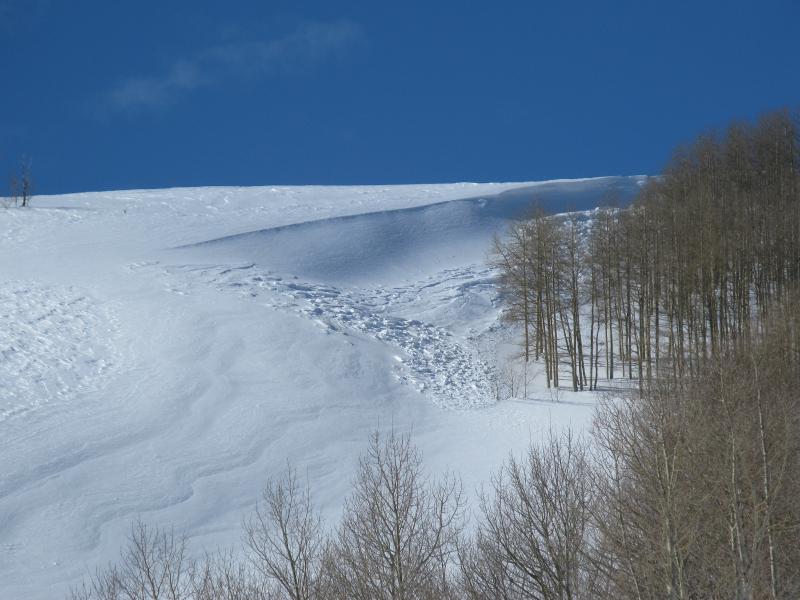
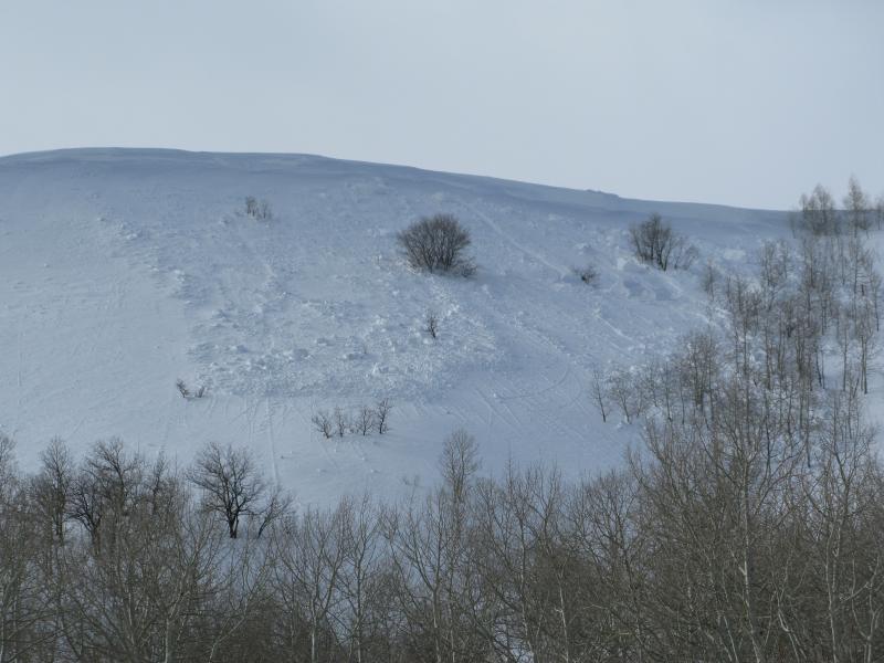
Not too shocking... I found a couple, day old, low elevation natural avalanches while working my way through Weber Canyon yesterday. A full list of Uinta avalanche activity is found here. |
| type | aspect/elevation | characteristics |
|---|

|

|
LIKELIHOOD
 LIKELY
UNLIKELY
SIZE
 LARGE
SMALL
TREND
 INCREASING DANGER
SAME
DECREASING DANGER
|
|
description
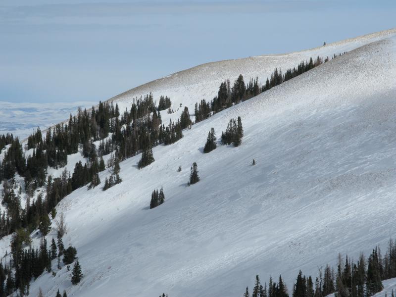
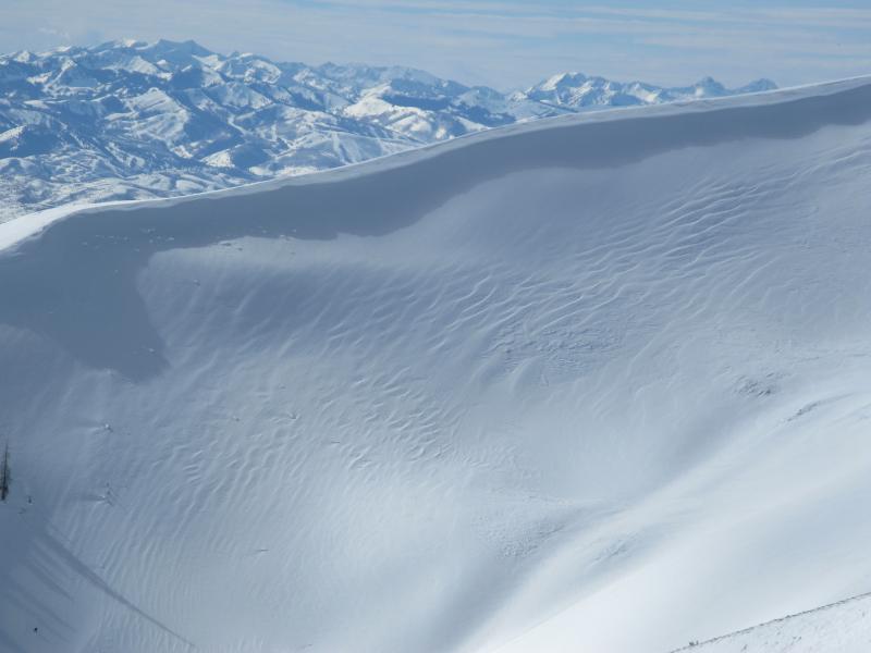
Recent winds blasted upper elevation slopes, creating thick, yet very stubborn wind drifts. Yesterday, I thought these would be reactive to my additional weight and was completely blown away by how quickly the snowpack got shrink-wrapped, welded in place, and seemed to heal overnight. Of course, the Uinta's are a big range and I bet there's still a wind drift or two lurking on the leeward side of mid and upper elevation ridges and around terrain features like chutes and gullies, that'll react to our addtional weight. Guilty until proven otherwise, I'm still avoiding fat, rounded looking pieces of snow, especially if they feel or sound hollow like a drum. |
| type | aspect/elevation | characteristics |
|---|

|
|
LIKELIHOOD
LIKELY
UNLIKELY
SIZE
LARGE
SMALL
TREND
INCREASING DANGER
SAME
DECREASING DANGER
|
|
description
I didn't find any weak faceted snow or surface hoar in my travels yesterday, but Mark's informative viddy explaining the setup on mid elevation, sheltered terrain clearly illustrates the tricky nature of a persistent buried weak layer. Found on the north half of the compass and now buried several feet deep, I don't think we're done with this problem but with a little homework, by digging around you can easily identify slopes that have a suspect snowpack and simply avoid them. |
| type | aspect/elevation | characteristics |
|---|

|
|
LIKELIHOOD
LIKELY
UNLIKELY
SIZE
LARGE
SMALL
TREND
INCREASING DANGER
SAME
DECREASING DANGER
|
|
description
A shallow overnight refreeze coupled with rain and continued warm temperatures today, will create damp, manky conditions at mid and lower elevations. Today, avoid any steep slope that feels unsupportable or punchy and steer clear of terrain traps like gullies and road cuts where wet, heavy, cement-like debris can stack up very deeply. |
 |
weather Warm air filters into the region and high temperatures reach into the mid 40's. Southwest winds continue to be a nuisance along the ridges, blowing in the 40's and 50's. Snow levels climb very high for this time of year, bringing rain to unusually high elevations. Moisture increases on Friday with a cold front pushing through the region early Saturday, bringing a brief period of snow.
|
| general announcements Remember your information can save lives. If you see anything we should know about, please participate in the creation of our own community avalanche advisory by submitting snow and avalanche conditions. You can call me directly at 801-231-2170, email [email protected] The information in this advisory is from the US Forest Service which is solely responsible for its content. This advisory describes general avalanche conditions and local variations always occur. The information in this advisory expires 24 hours after the date and time posted, but will be updated by 7:00 AM on Friday February 10th. |