25th Annual Black Diamond Fall Fundraising Party
Thursday, September 13; 6:00-10:00 PM; Black Diamond Parking Lot
25th Annual Black Diamond Fall Fundraising Party
Thursday, September 13; 6:00-10:00 PM; Black Diamond Parking Lot
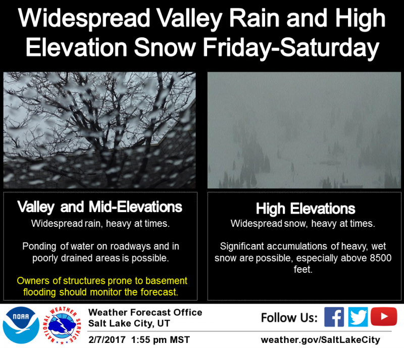
| Advisory: Uintas Area Mountains | Issued by Craig Gordon for Wednesday - February 8, 2017 - 3:18am |
|---|


|
bottom line Heads up... the avalanche danger is slightly higher on the southern half of the range from Trial Lake to Daniels where more snow and water stacked up. At and above treeline, the avalanche danger is HIGH. Both human triggered and natural avalanches are VERY LIKELY on steep, leeward slopes facing the north half of the compass, especially in terrain with an easterly component to its aspect. CONSIDERABLE avalanche danger is found on steep, shady slopes at mid and lower elevations and human triggered avalanches are LIKELY. Human triggered wet avalanches are possible at lower elevations and a MODERATE avalanche danger is found on steep, water laden slopes.
|
 |
avalanche warning THE FOREST SERVICE UTAH AVALANCHE CENTER HAS CONTINUED THE BACKCOUNTRY AVALANCHE WARNING. * TIMING...NOW THROUGH 6AM MST THURSDAY * AFFECTED AREA...FOR WESTERN UINTA MOUNTAINS. * AVALANCHE DANGER...THE AVALANCHE DANGER FOR THE WARNING AREA IS HIGH. * REASON/IMPACTS...RAIN, HEAVY SNOWFALL, AND STRONG WINDS ARE CREATING UNSTABLE SNOW AT ALL ELEVATIONS. VERY DANGEROUS AVALANCHE CONDITIONS EXIST, NATURAL AVALANCHES ARE LIKELY. STAY OFF OF AND OUT FROM UNDER SLOPES STEEPER THAN 30 DEGREES. AVOID AVALANCHE RUN OUT ZONES. THIS WARNING DOES NOT APPLY TO SKI AREAS WHERE AVALANCHE HAZARD REDUCTION MEASURES ARE PERFORMED. |
 |
special announcement We still have a few slots open for this weeks Sled Specific Avy Awareness and Riding Skills Class. More details here. Do you buy groceries at Smiths? When you register your Smith’s rewards card with their Community Rewards program, they will donate to the Utah Avalanche Center whenever you make a purchase. It's easy, only takes a minute, and doesn't cost you anything. Details here. |
 |
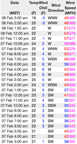
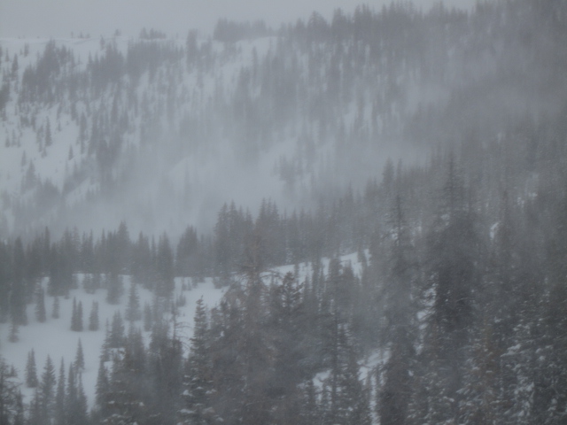
current conditions Skies cleared overnight and temperatures are just starting to fall, but still register in the 20's and mid 30's. Yesterday's storm was a little slow out of the gates, but finally materialized for the eastern front and the southern half of the range got stomped on! From Trial Lake to Daniels 12"-16" of dense, heavy snow stacked up... the North Slope clocked in closer to 10". In either case, westerly winds didn't discriminate, they nuked in the 60's and 70's along the high ridges. Real time wind, snow, and temperatures for the Uinta's are found here
Ted was in Gold Hill Basin yesterday and found very touchy fresh drifts along the ridges, but excellent riding conditions in low elevation, wind sheltered terrain. Snowpack observations and trip reports are found here. |
 |
recent activity
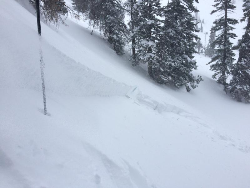
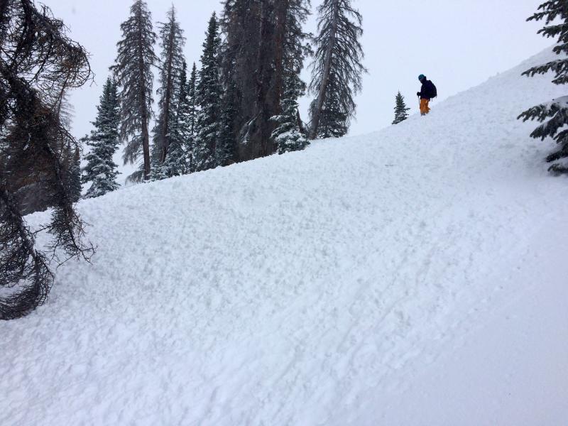
Very tender cornices and super touchy soft slabs rapidly formed on mid and upper elevation leeward slopes. A full list of Uinta avalanche activity is found here. |
| type | aspect/elevation | characteristics |
|---|

|
|
LIKELIHOOD
 LIKELY
UNLIKELY
SIZE
 LARGE
SMALL
TREND
 INCREASING DANGER
SAME
DECREASING DANGER
|
|
description
Westerly winds continue cranking along the ridges and there's no shortage of fresh snow available to form drifts sensitive to our additional weight. While found mostly on the leeward side of mid and upper elevation ridges and around terrain features like chutes and gullies, recent strong winds also got into low elevation terrain and formed drifts in unusual locations. Avalanche conditions are sketchy and you need to avoid being on, under, or connected to steep, wind drifted slopes.
Winds were smoking yesterday, even getting into thick trees and terrain that's generally protected. |
| type | aspect/elevation | characteristics |
|---|

|

|
LIKELIHOOD
 LIKELY
UNLIKELY
SIZE
 LARGE
SMALL
TREND
INCREASING DANGER
SAME
DECREASING DANGER
|
|
description
Surface hoar and near surface facets- Mark posted an informative viddy explaining the setup and his recent decision not to ride a slope because of the snow structure his crew found. On the north half of the compass, a fragile layer of surface hoar and weak, sugary, near surface facets were preserved and buried prior to the big January storm cycle. Suspect terrain includes mid and low elevation creek bottoms and terrain features where cold air pools. These weak layers are now buried several feet beneath the snow surface. Heavy snow, rising temperatures, and strong winds will bring these dormant layers back to life. It's a deceptive setup for sure, but it doesn't have to be a roll of the dice. With a little homework, by digging around you can easily identify slopes that have a suspect snowpack and simply avoid them. |
| type | aspect/elevation | characteristics |
|---|

|
|
LIKELIHOOD
 LIKELY
UNLIKELY
SIZE
 LARGE
SMALL
TREND
INCREASING DANGER
SAME
DECREASING DANGER
|
|
description
Rain, mixed with snow at lower elevations created damp, manky conditions. Today, avoid any steep slope that feels unsupportable or punchy and steer clear of terrain traps like gullies and road cuts where wet, heavy, cement-like debris can stack up very deeply. |
 |
weather Snow showers end early this morning, leaving partly cloudy skies and breezy conditions. It'll be warm with highs reaching into the mid 30's and overnight lows hovering near freezing. Very mild for Thursday with the next warm, windy storm slated to roll in for Friday and Saturday.
|
| general announcements Remember your information can save lives. If you see anything we should know about, please participate in the creation of our own community avalanche advisory by submitting snow and avalanche conditions. You can call me directly at 801-231-2170, email [email protected] The information in this advisory is from the US Forest Service which is solely responsible for its content. This advisory describes general avalanche conditions and local variations always occur. The information in this advisory expires 24 hours after the date and time posted, but will be updated by 7:00 AM on Thursday February 9th. |